NEXT Weather Alert: Winter storm system bringing heavy snow to southeast Michigan
(CBS DETROIT) - NEXT Weather Alert Day.
This system has a few differences from the ones before, especially with an admitted difficulty in the forecast. Unlike the last few ice storms, this one is bringing more snow.
Heavy wet snow will pile up across the region with the higher forecasted snow totals for our central counties.
Your NEXT Weather team is tracking this system and the NEXT Weather Tracker will be driving around the area letting you know all the current conditions.
NEXT Weather: What to expect into the weekend after winter storm in SE Michigan
CBS Detroit crew helps driver stuck in snow
Metro Detroit shelters prepare for higher demand during winter storm
The cold can be especially brutal for residents without permanent housing, and if you need a warm place to stay, there are a few locations offering hot meals and beds.
The Detroit Rescue Mission is gearing up to make room for an influx of families and individuals.
Organizers say that means making sure they have enough supplies and beds for accommodations.
If you're in need of an emergency shelter, you can call 313-993-6703.
Facilities:
Detroit Rescue Mission (men only)
- 3535 3rd Ave.
- 313-993-6703
Genesis House II (women and families)
- 12900 W. Chicago
- 313-309-5900
Genesis House III (women and families)
11037 Mack Ave.
Click here for more locations.
Detroit Metro Airport temporarily closes due to winter storm
The Detroit Metro Airport says it temporarily closed after a winter storm hits Southeast Michigan.
"Please check your flight status with your airline before heading to the airport," Airport officials said in a tweet.
As of 7 p.m., more than 200 flights arriving and departing from the airport were canceled or delayed.
Winter storm timelapse
A view of road conditions Friday night as snowfall continues in SE Michigan
CBS News Detroit's Ibrahim Samra tries to build a snowman
Power outages mounting up in southeast Michigan
Power outages are mounting up in southeastern Michigan as a results of Friday's winter storm.
You can view DTE Energy's outage map or Consumers Energy's outage map.
You can also view your outage status for DTE Energy or Consumes Energy.
You can report an outage for DTE Energy or Consumers Energy.
Heaviest snow still moving in to southeast Michigan
Monroe County Sheriff's Office urges caution during winter storm
Clearing snow in Detroit
Staying safe while shoveling your driveway
Road conditions rapidly deteriorating
Road crews brace for winter storm in Macomb County
Thundersnow reported in area
Oakland County road crews prepare for winter storm
Road crews in Oakland County are preparing for a 16-hour shift as a winter storm hits southeast Michigan Friday.
Friday morning, the priority was to pre-treat roads by spraying liquid brine to keep ice from forming. Once the freezing rain or snow starts, crews will focus their attention on overpasses and ramps, as those are the places that ice up first.
Thanks to the mild winter Michigan has enjoyed this year, Oakland County has saved money, specifically on overtime and their salt supply.
The county has nearly 7,000 tons of rock salt in each of its salt barns, but they're still dealing with some of the mess last week's ice storm left behind.
Local Satellite & Radar
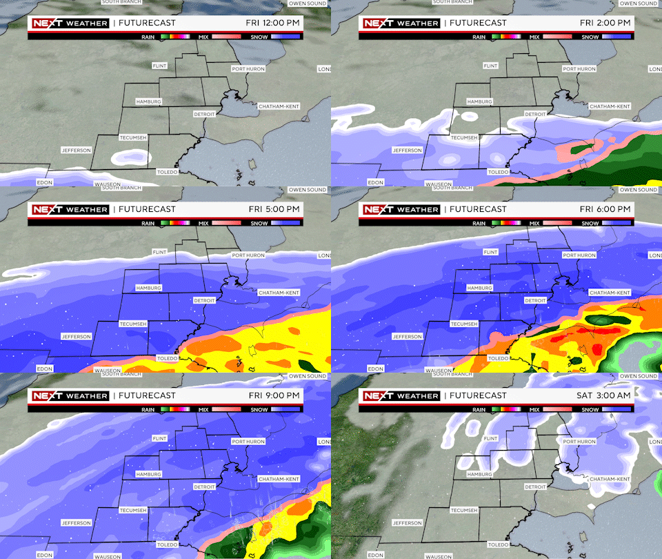
Winter storm timeline
NEXT Weather final forecast update before winter storm
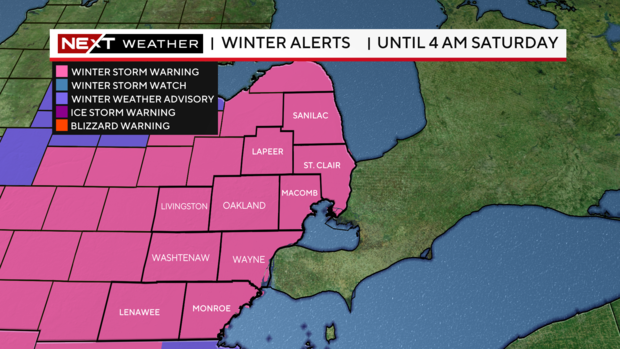
Latest winter storm alerts
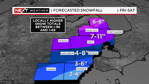
Forecasted snowfall
Winter storm update
Snowfall Forecast as of 6AM
March 3rd, NEXT Weather Alert Day Updated Snowfall Forecast
NEXT Weather forecast ahead of Friday's winter storm
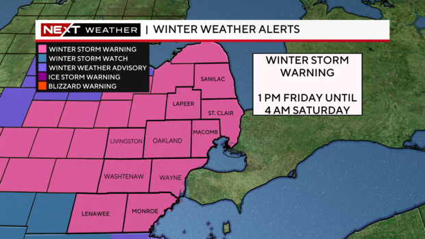
Winter Storm Warning issued for SE Michigan
Several counties in Southeast Michigan are now under a Winter Storm Warning through 4 a.m. Friday.
The warning is in effect for the following counties:
- Genesee
- Huron
- Lapeer
- Lenawee
- Livingston
- Macomb
- Monroe
- Oakland
- Saginaw
- Sanilac
- Shiawassee
- St. Clair
- Tuscola
- Washtenaw
- Wayne
Snowfall totals are expected in the range of 4 or 5 inches in the lowest areas closer to the Ohio state line, up to 10 inches in our northern communities north of M-59.
Snowfall rates of 1 to 2 inches per hour are possible in a three- to six-hour window close to the evening commute and past sunset. These rates can be dangerous as visibility drops rapidly and snowfall accumulates on the pavement in a short period of time.
In addition, strong wind gusts in the 40 mph range are likely and will further reduce visibilities.
Wind gusts may also cause isolated power outages.
Snowfall will taper off after 2 a.m. Saturday morning.
Snowfall coming Friday morning
Snowfall begins very light in the late morning hours moving from south to north. Snow should be more widespread, but remain light, after the noon hour as it continues to move north. Snowfall begins to truly fall after 2 p.m. Friday.
Between the hours of 4 p.m. and 10 p.m., the snow should fall at the heaviest rate. Some snowfall rates of 1 to 2 inches per hour are possible, along with a chance for thundersnow. Snowfall tapers off after 10 p.m. and is over by the midnight hour.
NEXT Weather forecast for March 2, 2023 (Tonight)
What is a NEXT Weather Alert Day?
Friday is a NEXT Weather Alert Day.
What does this mean? Our team expects higher than normal impacts to travel and/or daily life from a storm system that requires larger coverage. We increase staffing and clear the way for us to do things like break into programming or gear up teams to be mobile, for example in the NEXT Weather Tracker.
We'll take temperature readings of the road surface, use the mounted weather station to feed back data in different parts of the storm, and also work on updates from places like road commissions on expected impacts with staffing or road clearing timelines.
Breaking down a timeline, snow totals and main impact
Forecasted Snow Totals
Expected snowfall amounts Friday through Saturday morning.
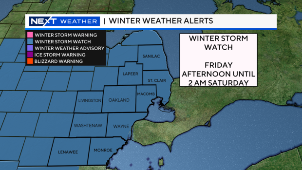
Winter Storm Watch
Winter Storm Watch: Start Friday afternoon and extend until 2 a.m. Saturday.
Thursday 6 a.m. update
Thursday 6 a.m. update.
Snow, rain and ice making its way to SE Michigan
Timing continues to be more consistent, focusing mainly on the afternoon Friday through most of Friday night.
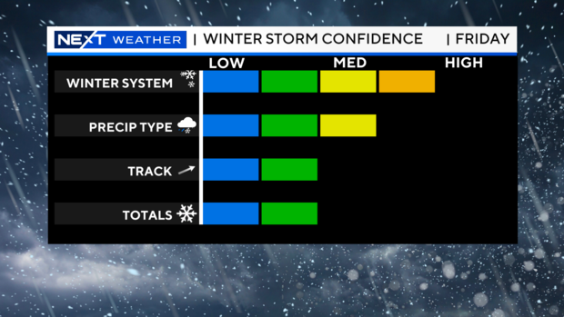
The primary issue is the storm track, which has been all over the board until Wednesday night.
The area of low pressure hasn't been over land for us to measure, which meteorologists have now been able to do on the west coast.
With this new data, we are seeing a slight southern shift in the heavier snowfall bands.
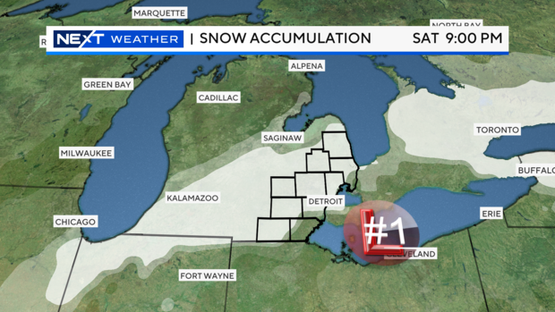
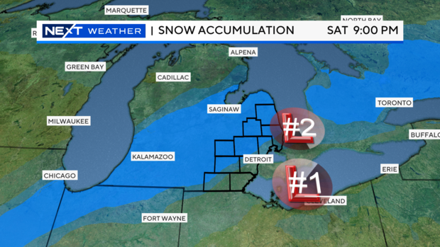
At the moment, there are really two main tracks that the area of low pressure can take.
The southernmost track, track No. 1, brings heavy snowfall directly into the central and northern counties in Southeast Michigan, along with portions of central Michigan and into the Thumb.
Snowfall is the wet/heavy type and would be difficult to shovel, so it's important to keep up with the accumulation.
Rain would be likely to move through parts of the counties closest to the Ohio border, and this would therefore cut down on snowfall amounts specifically in those areas.
Storm track No. 2 brings the area of low pressure further north and would leave the heaviest band of snowfall over central portions of the mitten.
Snowfall type would be the same, but amounts in the Metro area would drastically diminish because of this.
Rainfall also makes a more notable appearance and would aid in cutting snow totals even further.
It's important to note that updates to these tracks are coming within the next 8-12 hours as truly raw data finally becomes available.
Right now, the bottom line is to have the shovel handy and gas for the snow blower.
You're going to have at least a couple of inches to clear, but the track of the heaviest snowfall is still in flux and it's good to be prepared now if the system continues to slide south as some recent data has shown.
You can download the CBS News app to watch CBS News Detroit anytime, and we are available to stream live on PlutoTV.
Stay with the NEXT Weather Team as this storm system evolves.

