Denver Weather: Snow Heading For Colorado, Including Denver
DENVER (CBS4) - More snow is quickly heading to Colorado. Our next system will race towards our state on Wednesday. Our temperatures will drop to the 50s tomorrow, with snow starting in the northern mountains around noon. This will quickly spread and head into the Front Range possibly in time for the evening rush hour.
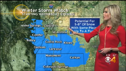
We could possibly see rain first in Denver, with could cut into our snow totals if the rain sticks around for awhile. We should see snow by the later evening hours. This storm will mainly impact areas south of Denver, but the city could see anywhere from 1 to 4 inches of snow. A few bands of snow could produce more in some areas.
South of Denver heading toward Castle Rock and near the Palmer Divide we could see much more. A Winter Storm Watch for 5 to 8 inches for those areas will start in the evening. Parts of the foothills are also under the watch, but could see up to a foot of snow.
Overnight into Thursday, the snow will continue to move south and should clear from the Denver area. Our southern mountains will see a nice shot of snow through the early afternoon on Thursday.

This storm won't be as cold as the last one for Denver. We'll see sunshine in the afternoon on Thursday and should get into the low 40s in the afternoon.
Our next storm arrives on Sunday, but until then we'll back to sunshine for a few days.

