Colorado Weather: Storm brings needed moisture but misses the mark on snowfall
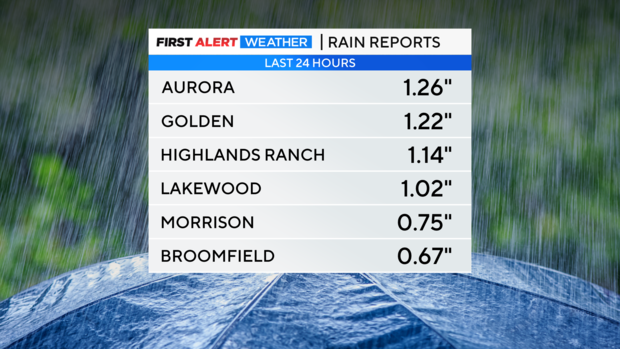
The spring storm impacting Colorado on Wednesday moved too far south to bring big snow to the foothills but still managed to bring more than 1 inch of rain to many areas.
The storm was forecast to move essentially along the Colorado-New Mexico state line Tuesday night but instead shifted about 100 miles farther south closer to Santa Fe. That southerly shift meant far less upslope for the foothills and the Palmer Divide.
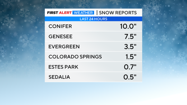
Therefore most areas in the foothills of Jefferson, Boulder, and Larimer Counties as well as the higher terrain of Douglas County generally measured less then 6 inches of snow. The potential existed for more than 12 inches of snow in some areas had the upslope developed. There were a handful of area that did report higher snow totals Wednesday morning like Conifer with 10 inches.
Meanwhile all areas below about 6,500 feet in elevation experienced all rain Tuesday night and Wednesday morning. It was the wettest period of the year so far for many neighborhoods. Aurora, Golden, Highlands Ranch, and Lakewood were among many area that measured over 1 inch of rain.
The official rain total as measured at Denver International Airport was significantly lower. In fact the airport only measured 0.31" of rain and therefore the city remains 0.74" below normal for April and 0.40" below normal for 2023.
Much drier weather will dominate the Front Range from Wednesday afternoon through Thursday afternoon. Then another storm system will bring rain and snow back to the region Thursday night into Friday morning. Up to 1 inch of snow accumulation is possible in the Denver metro area mainly on the grass Friday morning.

