Wildfires are burning. Where is Colorado's summer monsoon rain?
With three significant wildfires burning along the Front Range, many Coloradans have been asking what has happened to the summer rain caused by the summer monsoon.
The monsoon is eagerly welcomed each in year Colorado as a way to cool extreme summer temperatures and decrease wildfire danger just as trees, grasses and other fuels are usually drying out after spring moisture.
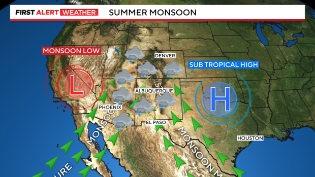
The phenomenon known as the summer monsoon is a seasonal shift of the wind in the upper atmosphere that usually first develops in June or July. During most of the year, the prevailing wind over the Four Corners region including Colorado is from the west. But in the summer, as heat builds across the continent, a large area of high pressure usually builds across Texas. This shifts the prevailing wind to come from the southeast which transports moisture from the Gulf of Mexico into the region. At the same time, a stationary area of low pressure develops over Nevada and helps transport moisture from the Pacific Ocean off Baja California into the region. The result can be a double supply of moisture of Colorado and usually an uptick in rain starting in July.
But so far in 2024, this monsoon pattern has only developed in southern Arizona and New Mexico. And most meteorologists blame the current lack of a monsoon pattern farther north on a lack of a El Niño or La Niña weather pattern. Officially North America is transitioning from El Niño to La Niña but that has not happened yet and it's expected conditions will remain "neutral" through at least September.
The high pressure ridge needed in Texas to transport extra moisture into Colorado has only recently developed and it's farther east and south than usual. At the same time, low pressure that is usually over Nevada and been more frequently parked over Arizona which is helping to keep the moisture farther south.
And without a El Niño or La Niña weather pattern, the more typical summer monsoon pattern for Colorado many never materialize this summer. If it does, it doesn't seem likely to happen before September which spell a troubling month of August for Colorado in terms of extreme temperatures, below normal precipitation and frequent high fire danger.
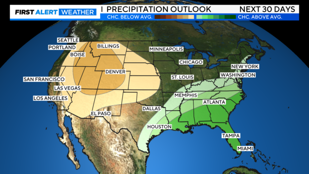
The precipitation outlook for August from NOAA's Climate Prediction Center shows a good chance for below normal rainfall in Colorado. The outlook for September could end up being better, but it doesn't seem likely at this time.
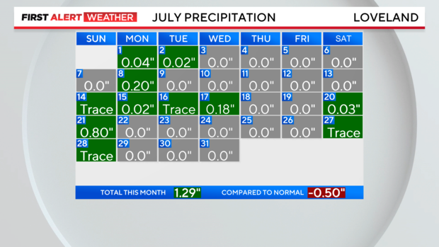
Needless to say, the lack of much moisture so far this summer has contributed to the dry fuels the Alexander Mountain Fire and Stone Canyon Fire near Loveland and Lyons have used to grow. In Loveland, precipitation for July has been 0.5 inches below normal which is significant for Colorado standards.
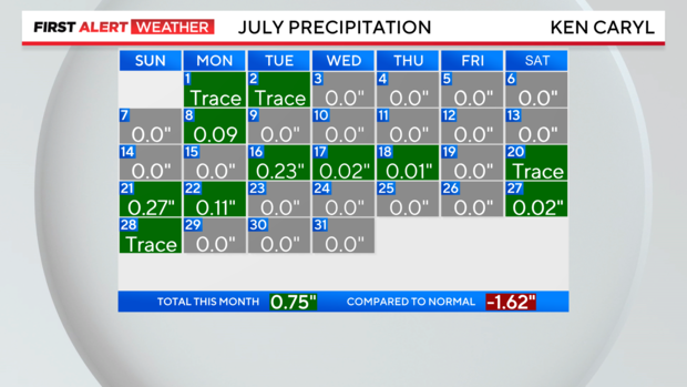
Near where the Quarry Fire is burning in Jefferson County, Ken Caryl averages 2.37" of rain in July but this month has only received 0.75".
