Understanding Severe Thunderstorm Risk Categories From National Weather Service
By John Dodge
CHICAGO (CBS) -- With the start of unsettled springtime weather, the National Weather Service has modified the way it categorizes the anticipated risk of severe storms.
On Thursday, for example, NWS is forecasting an "enhanced risk" for severe storms.
In this case, the severity of the storms will depend on whether Wednesday's showers move out overnight, clearing the way for morning sunshine, CBS 2's Megan Glaros says. That sun, combined with humidity, would increase temperatures during the day, adding to the chances of storms in the afternoon. If clouds persist in the morning, the chances for severe storms would decrease.
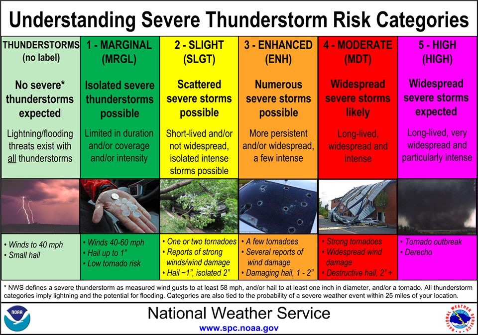
Under the new definitions, "enhanced risk" means "numerous severe storms" are possible, which could be more widespread and persistent.
The weather service defines a "severe storm" as a thunderstorm with "wind gusts to at least 58 mph, and/or hail at least one inch in diameter and/or a tornado."
There are now six classifications for severe weather:
Thunderstorms (no label): No severe thunderstorms expected, winds to 40 mph, small hail.
Marginal Risk: Isolated severe storms are possible, limited in duration or intensity. Winds up to 60 mph, hail up to one inch, low tornado risk.
Slight Risk: Scattered severe storms possible, short-lived, some isolated intense storms possible. One or two tornadoes, wind damage potential, hail.
Enhanced Risk: Numerous severe storms possible. Potential for wind and hail damage and a few tornadoes.
Moderate Risk: Widespread severe storms likely, long-lived, widespread and intense. Strong tornadoes, widespread wind damage and destructive hail.
High Risk: Widespread severe storms expected, long-lived, widespread and "particularly intense." Tornado outbreak.
All thunderstorms "imply lightning and potential for flooding," the NWS says.


