Severe thunderstorms bring heavy rain, flooding to Chicago area


CHICAGO (CBS) — A line of severe thunderstorms produced wind damage and flash flooding Saturday night, but was moving out of the area early Sunday morning.
A total of 4.75 inches of rain fell in Wauconda, and flooding was reported in Lake County, Illinois, and Kane County. Two vehicles were submerged at Route 176 and Route 41 in Lake County, though there was no word that there were people inside of them.
Tree damage was reported in St. Charles and Geneva.
The lumbering storms have taken their time dragging their way across the Chicago area. The storms have been "training," repeatedly pounding the same areas for hours at a time like a train car.
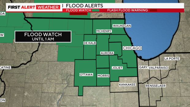
Flash Flood Warnings continued for much of the area, including Chicago, until 3:15 a.m. Sunday. Motorists are warned never to drive through a water-covered roadway—"Turn Around, Don't Drown."
A flood watch was also in effect for the Chicago area until 1 a.m.
Earlier, the same system earlier brought tornado warnings in southern Wisconsin. Tornadoes were spotted in Janesville and Walworth, Wisconsin.
The storm system is expected to leave the immediate Chicago area by around 1 a.m. But in the wee hours Sunday morning, the storms are still expected to impact Northwest Indiana.
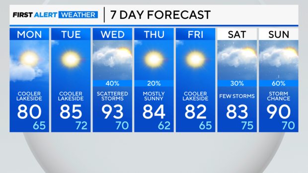
What to expect in the upcoming week
Behind the storms, cooler, less humid weather blows in on Sunday and Monday. High temperatures spike back into the 90s Tuesday with another risk of strong storms.
Sunday: Partly cloudy and cooler. High: 80, cooler lakeside.
Monday: Mostly sunny. High: 85, cooler lakeside.