Near-record-breaking highs with showers, thunderstorms for Chicago area Thursday afternoon

CHICAGO (CBS)-- Two rounds of showers with the possibility of thunderstorms are expected for the Chicago area on Thursday. Here's what you can expect.
Strong winds develop by the morning hours with gusts up to 40 miles per hour possible, according to the National Weather Service. While an advisory has not been posted, Chicagoans should take caution with high winds as storms develop later in the day.
Spring-like temperatures are expected, with highs in the mid-50s, near 60 degrees. The record high for Feb. 8 of 62 degrees was reported in 1900, and again in 1925, the NWSsaidd.
The first round of showers will move through the area by afternoon, with only light rainfall expected. The strength of storms during the second round Thursday evening could be strong to severe in some places, the NWS reports.
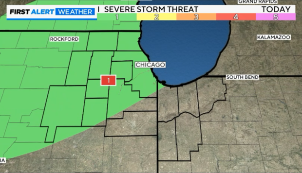
The strongest storms will develop near I-39, but thunderstorms weaken, moving into the Chicago area. Chicago remains at a marginal storm risk for isolated storms Thursday night.
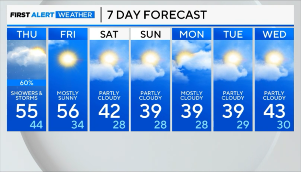
Near-record-breaking warmth is expected to continue through Friday. Friday's high temperatures could break a record with highs near 56 degrees and mostly sunny skies. The record high temperature for Feb. 9 is 56 degrees.
The temperatures will dip to the 40s during the weekend, which is still seasonably warm for February.