Storms bring heavy rain and strong winds, take down trees, knock out power in Chicago area


CHICAGO (CBS)—Severe storms pounded their way through the Chicago area Tuesday night after an extremely hot and humid afternoon, leaving a path of ripped-down trees, power lines, and residents stuck in the dark.
Severe thunderstorm warnings were issued through the late afternoon and evening. As a result of the storms, 44,935 Northern Illinois customers were without power as of 9:12 p.m., according to ComEd.
As of late Wednesday morning, 14,446 customers were still without power. ComEd said it hopes to have all power restored by Thursday morning, with 80% of outages fixed by Wednesday night.
Power outages impacted Deerfield School District 109. The superintendent canceled classes on Wednesday while crews worked to restore power to the schools.
The storms picked up in Crystal Lake, and winds were blasting at 80 mph by the time they arrived in Glencoe. Numerous north and northwest suburban communities saw tree and power line damage, and while damage was less severe in the city, the storm was no less dramatic.
Storms blast in with swirling cloud at Lake Michigan
On the lakefront near Fullerton Drive Tuesday evening, the storm came in suddenly and dramatically. One minute, there were dozens of people swimming in the lake on a record-hot day, and the next, people were running away from strong winds and blowing debris.
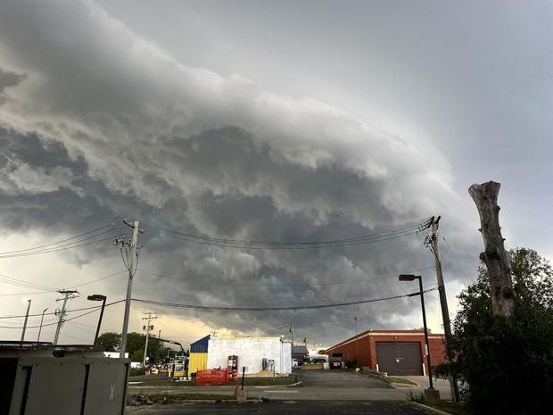
Time-lapse video showed a massive shelf-looking cloud covering the lake just north of Fullerton Drive. The clouds moved in quickly and started to swirl, and CBS News Chicago's team quickly ran for cover as rain started to pour down.
The type of crazy rotating cloud seen over the lake is called a gustnado—which is not a tornado but a spin coming out of a gust front.
As people tried to leave the lakefront, some people basked in the rain—while others scurried away as their belongings were blown around.
Finally, after that first round of crazy rain, Chicago Police came by to make sure no one else was on the lakefront.
The National Oceanic and Atmospheric Administration also warns of a seiche phenomenon, when the water level can rapidly decrease and then quickly return.
Storms knock down trees around northern suburbs
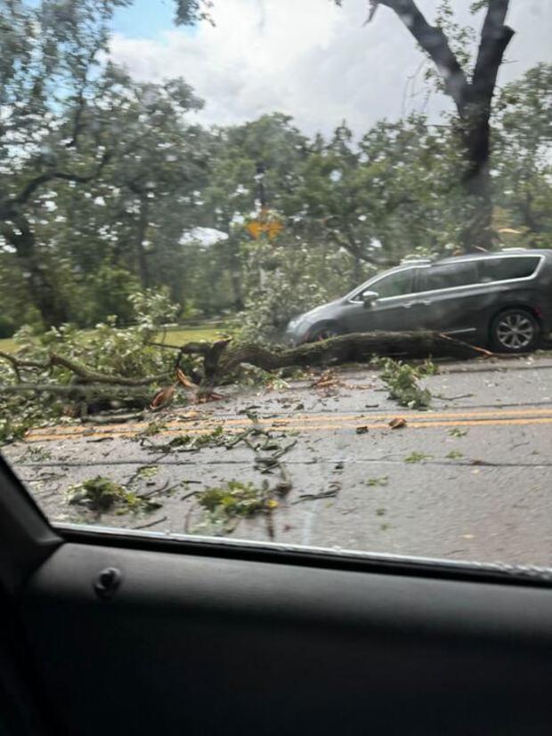
Strong winds from the storms sent trees crashing to the ground near the Northwestern University campus in Evanston. At Judson Avenue and Church Street—just south of the campus, west of Sheridan Road and the lake, and east of downtown Evanston—a massive tree came crashing down while a man was sitting in his car.
Cordell Green works in Evanston and was in the car for a lunch break. Somehow, he was uninjured.
"Next thing you know, a tree fell in front of me, and a tree fell on top of my car," Green said. "My fear was that the root of the tree was going to be on top of my car and instantly kill me at that time."
But not only was Green uninjured—his car wasn't even scratched. He kissed a cross in his car afterward to give thanks.
The spot where the massive tree fell is also where Mejr Lutolli said she parks for work almost every day.
"When I get up and I look, I said, 'Oh my gosh, I think my car is there.' I completely forgot where I parked. And I look I laughed, 'Oh good!'" Lutolli said. "You know, this is unbelievable. I think I was just a lucky one."
An Evanston ambulance and fire truck tried to make their way down Judson Avenue with their lights and sirens on, but they had to back up due to the obstruction from the tree.
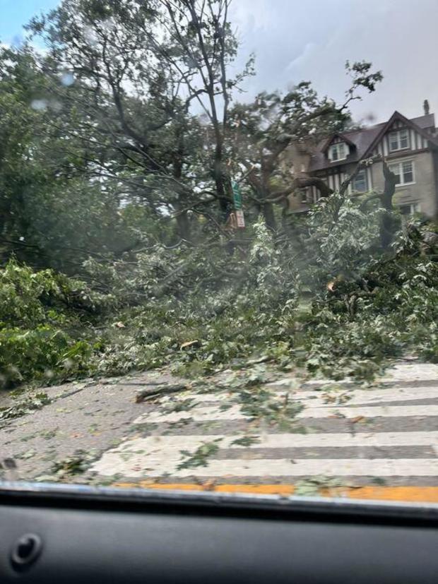
On Sheridan Road, a driver wasn't as fortunate—a falling tree damaged the car's roof. Downed trees were also seen along Orrington Avenue, as documented in photos supplied by National Weather Service employee Courtney Carpenter.
In Glencoe, a few suburbs to the north, the cleanup was just beginning in areas where downed trees covered streets and even stopped traffic.
In Wauconda, ominous clouds hung low. Powerful winds snapped trees and threw them into power lines, and the storm twisted and destroyed heavy patio furniture.
"Wind flew through, and hail came. We thought our windows were going to get busted out," a Wauconda resident said. "We seen this get turned like a big knot, then we seen the roof of the shed blow off, and the tree went and leaned on."
Trees also came down in Vernon Hills—with some almost missing the nearest house as they fell. Minor flooding was also reported.
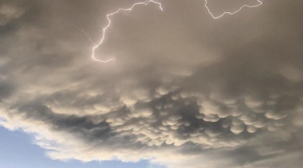
Just before 6:30 p.m., a dramatic ragged shelf cloud demarcated the transition from rain to dust from Prospect Heights looking north into Wheeling.
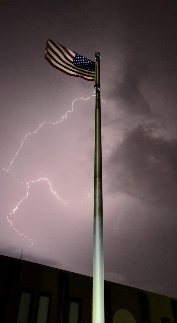
Lightning was also seen backlighting Old Glory at Chicago Executive Airport in Wheeling.
Strong winds associated with the storm in the north and northwest suburbs disrupted inbound and outbound Metra service on the Union Pacific North and Northwest lines. Service did eventually resume after delays of some 50 minutes.
Later on the Union Pacific North Line, inbound and outbound trains were halted near the Braeside station in Highland Park due to a tree on the tracks.
The White Sox game against the Texas Rangers was suspended after a mere four pitches in the first inning because of the storms. They will play a straight doubleheader on Wednesday.
The worst of the storms were over for the Chicago area by 10 p.m., but thunderstorms persisted through the southwest suburbs, the Kankakee River Valley, and Northwest Indiana.
A severe thunderstorm watch remained in effect for LaSalle, Grundy, Kankakee, Will, Livingston, Ford, and Iroquois counties in Illinois and Lake, Porter, Jasper, Newton, and Benton counties in Indiana until 11 p.m.
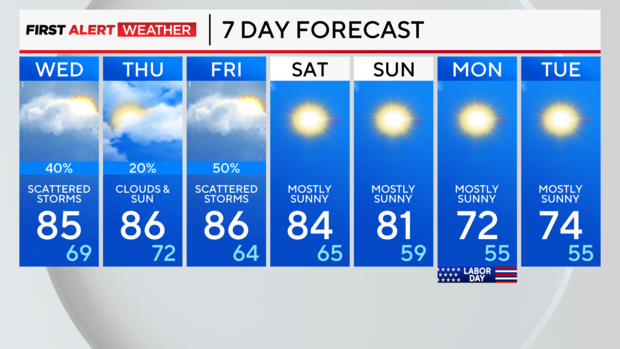
Showers linger overnight and into early Wednesday. Lows will be in the mid-70s Tuesday night.
Wednesday and Thursday are less hot, with highs in the low to mid-80s. The coolest temperatures will be near the lake.
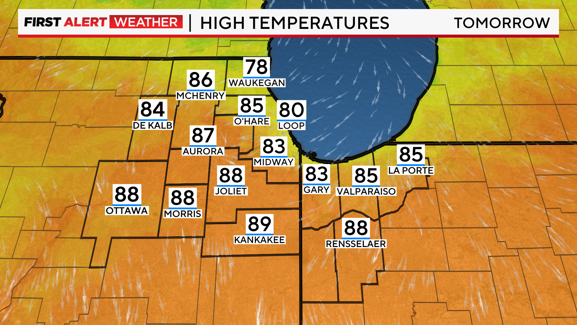
Conditions will still be humid, though, with heat index values in the 90s. A 30% chance of showers and storms will also remain.
Scattered storms are expected for Friday as a front moves into the area. Highs will be in the 80s, then fall to the 60s Friday night.
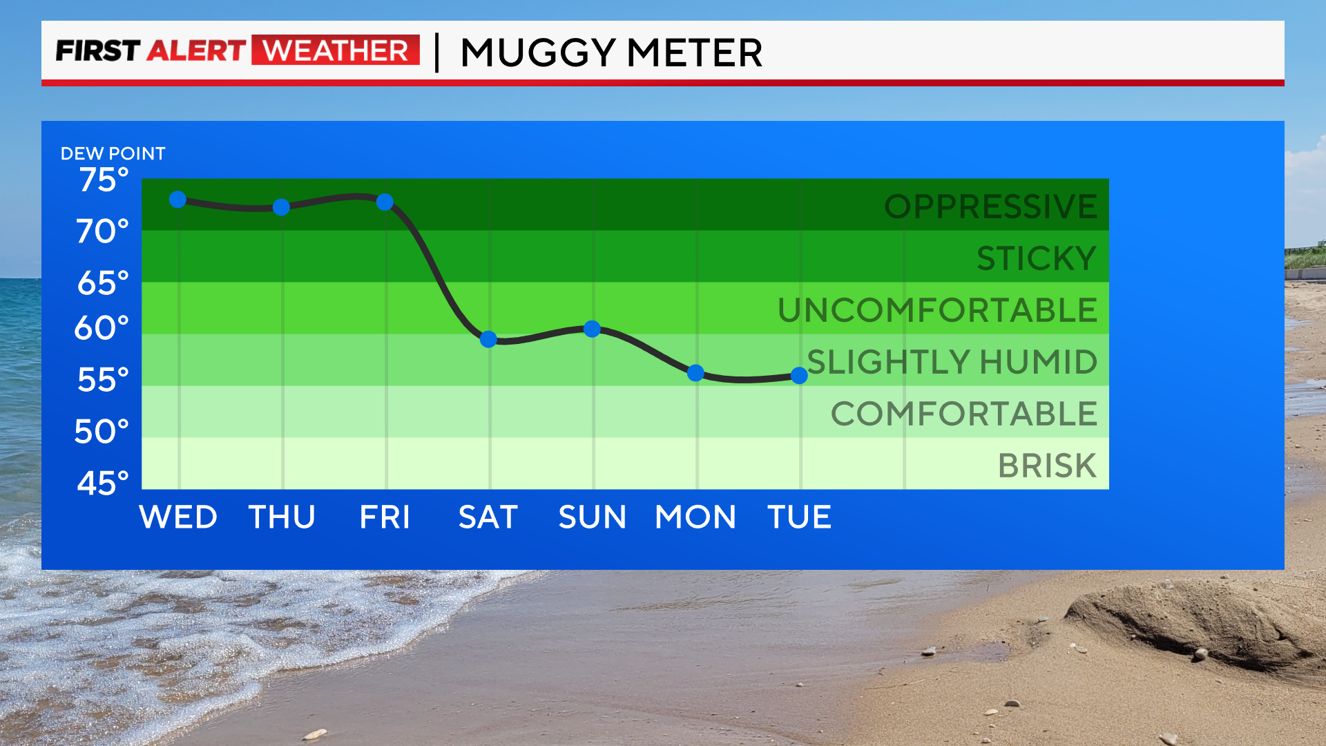
Cooling temperatures and falling humidity are forecasted for a great holiday weekend. We'll be in the low 70s for Labor Day Monday into Tuesday of next week.