Lake-effect snow to affect parts of Chicago area through Monday
CHICAGO (CBS) — On Sunday evening, system snow that impacted millions across the country's midsection was starting to wind down.
However, winds were starting to pick up, which was generating lake-effect snow in the Chicago area.
The heaviest lake-effect snow plumes are expected to be around the lake shore, and a steady band will go around the lake starting Sunday night and continuing through early Tuesday morning.
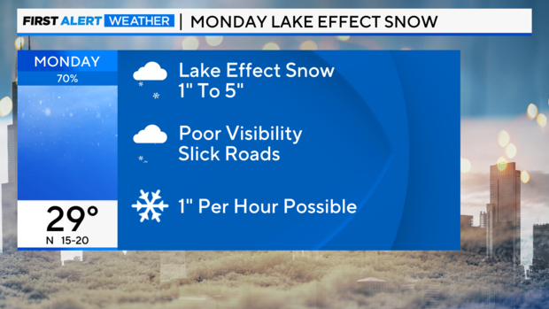
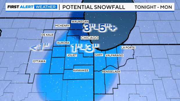
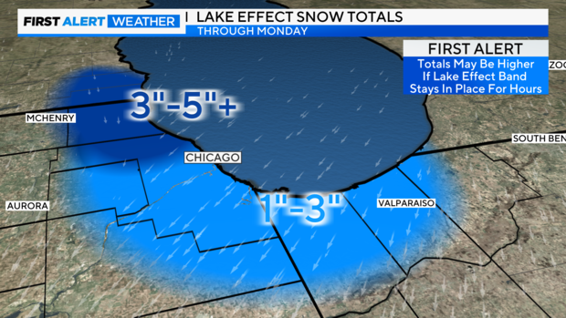
Lake County in Illinois will be under a winter weather advisory from midnight Sunday night until 4 p.m. Monday. The most significant lake-effect snow is expected in Lake County, with generally 3 to 5 inches of snow possible.
For Cook County, and Lake and Porter counties in Indiana, 1 to 3 inches of lake-effect snow will be possible.
To note, lake-effect snow is very localized, so it is hard to forecast which areas will get impacted. But it is must be noted that getting underneath any snow will result in slick covered roads and poor visibilities.
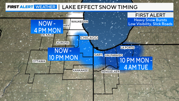
The lake-effect snow is expected to impact Lake County, Illinois first, starting Sunday night through Monday morning. Then, as the winds take a more northerly track, lake-effect snow will focus on Cook County around noon Monday, and will then impact Northwest Indiana Monday evening through early Tuesday as winds shift towards the north and west.
The City of Chicago advised residents to be prepared for lake-effect snow overnight, along with cold weather throughout the week to come.
IDOT crews prepare roads for morning commute
On I-80 in southwest suburban New Lenox, traffic was moving normally Sunday night—and Illinois Department of Transportation crews were on the scene in hopes of ensuring it stayed that way.
Some IDOT workers came in after sundown to work while the rest of the drivers were asleep. They filled salt spreaders and washed any remnants of the last storm off their lights.
The workers were racing against the sunrise—trying to keep the roads clear for the morning commute.
At the IDOT maintenance center in south suburban Harvey, a couple of the IDOT vehicles were seen parked in the yard and a snow plow was out front. The salt dome at the maintenance yard was open amid below-freezing temperatures.
IDOT crews knew what they were up against, having seen the havoc wreaked by the system snow downstate earlier in the day.
In Chicago, the Department of Streets and Sanitation has deployed its snow fleet to address snow and ice along the city's arterial routes and DuSable Lake Shore Drive. Streets and San noted that during active snowfall, the city's snow fleet can be monitored in real time at chicagoshovels.org.
Downstate Illinois, much of nation's midsection clobbered by system snow
Downstate Illinois got slammed by a snowstorm Sunday afternoon. A winter storm warning was in effect throughout central and southern Illinois until Monday—at 6 a.m. in some counties and noon in others.
CBS affiliate KMOV 4 in St. Louis warned of snow totals of 8 to 12 inches or more in some downstate Illinois communities—including Bowling Green, Carlinville, and Vandalia.
Farther south, including in St. Louis, a heavy mix of snow and sleet was falling late Sunday. Farther south still in Missouri and parts of downstate Illinois, mostly freezing rain was seen, and power outages were anticipated.
Illinois State Police Troop 6—which patrols highways in 12 downstate counties including Sangamon County, where Springfield is located—advised motorists in those areas not to travel at all Sunday unless absolutely necessary due to hazardous road and visibility conditions caused by the snowstorm, CBS affiliate WCIA in Champaign reported.
Kansas City and St. Louis picked up more than a foot of snow on Sunday alone.
Farther to the west in the Great Plains, conditions were even worse. Heavy snowfall that was expected to amount to up to 15 inches, and wind gusts of over 40 mph, were creating blizzard conditions in parts of Kansas, Nebraska, and Missouri.
Snow and ice blanketed roadways throughout Kansas. In northeast Kansas, most roads were closed.
The winter storm system also stretches across central and southern Indiana, Kentucky, southern Ohio, West Virginia, Virginia, Maryland, Delaware and parts of Pennsylvania, New Jersey, and Delaware. CBS affiliate WUSA in Washington, D.C., reports 6 to 10 inches are expected for the nation's capital.
In Indiana, Governor Eric Holcomb activated highway assistance teams from the Indiana National Guard for areas expecting dangerous road conditions.
This system affected parts of the Chicago area Sunday evening—but not nearly as severely.
Forecast at a glance
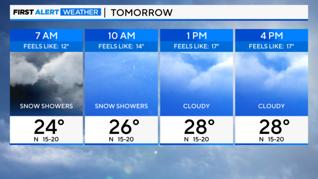
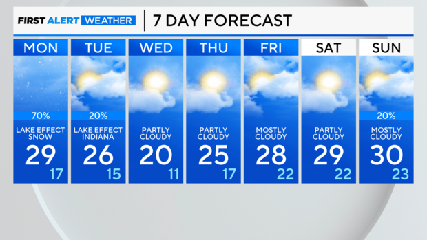
Sunday night: System snow moves out. Winds pick up, gusts near 30 mph. Turns on lake-effect snow machine. Low of 24.
Monday: Lake-effect snow through all commutes. High of 29.


