Chicago First Alert Weather: Winter storm watch ahead
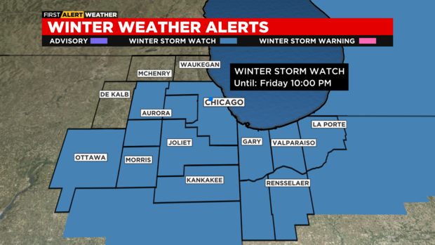
CHICAGO (CBS)-- A winter storm watch has been issued in the Chicago area; here's what you need to know.
According to CBS 2 meteorologist Robb Ellis, the wintry system expected to move through the area on Friday has been a forecasting challenge, but with new consensus arriving this evening, we feel more confident in the forecast we're putting forth.
The watch is in effect for northeast Illinois and northwest Indiana from Friday morning until Friday evening.
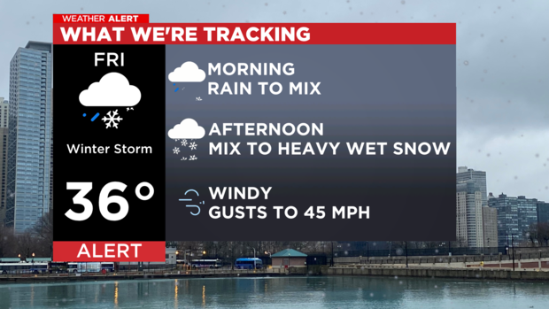
The storm system is expected to hit the Chicago area Friday morning and into the afternoon with soaking downpours and thunderstorms possible. Heavy rain is expected to change to snowfall as temperatures drop by the afternoon.
Some areas could see five to eight inches of snow. However, the forecast models are not in agreement on snow totals, meaning that confidence in those amounts is relatively low.
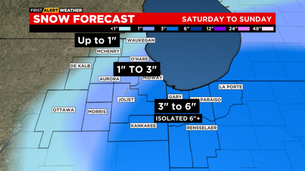
Rain changing to snow will lead to some accumulation, however, amounts in Chicago will be ZERO for many locations, with a steep increase to the south and east of the city. (see map)
Winter Storm Watches still remain in place, but will likely be replaced with Winter Weather Advisories (possibly Winter Storm Warnings) tonight.
It is possible that the area might only get two to four inches. Accumulations will depend on when the precipitation turns from rain to snow and the track of the storm.
Some models show the snow falling more significantly to the east of Chicago, with higher totals in areas around Chesterton, Ind., and very little accumulation in Chicago.
Other models track the snow falling more directly over Chicago. So, northern suburbs may see little accumulation, with a few inches in the city and up to six inches in northwest Indiana.
Windy conditions mixed with heavy, wet snowfall could lead to rapid accumulations on trees and power lines. Power outages are possible.
Friday evening commuters will be most impacted by the winter storm conditions. Slick roadways, flooding and low visibility are expected to cause hazardous commuting conditions.
Snow tapers off by Friday night giving way to weekend sunshine.
Tonight: Cloudy. Low 33.
Friday Morning: Rain showers, mainly after 8 AM. May mix with snow at times through noon.
Friday Afternoon: Rain changes to snow, but begins to move east. Some locations in the city may see precipitation end BEFORE the changeover. Snow may be heavy briefly south of the city and into NW Indiana.
Across Chicago, 0 to 3 inches (NW to SE). Southern Cook to Kankakee and into NW Indiana may see three to six inches with isolated amounts over six inches.
This may end before the evening commute if the system pulls away quickly, though some snow may linger in Indiana.
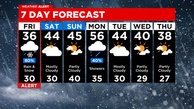
EXTENDED FORECAST: A mild few days ahead with more showers arriving Monday.

