Chicago Weather Alert: Winter storm socks parts of area
CHICAGO (CBS) -- Snow was falling south of Chicago and in Northwest Indiana Friday afternoon just in time for the evening rush.
The track of the storm system remained unclear in the days leading up to
Friday, but it ended up tracking to the south.
CBS 2's Lauren Victory reported road conditions were slippery in Valparaiso late Friday afternoon. She reported seeing two vehicles crunched up after smashing into the median within 15 minutes.
The winter storm system is expected to move out late Friday.
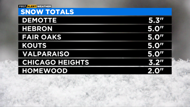
Snow totals for Friday
Demotte: 5.3"
Hebron: 5.0"
Fair Oaks: 5.0"
Kouts: 5.0"
Valparaiso: 5.0"
Chicago Heights: 3.2"
Homewood: 2.0"
Winter storm hit Northwest Indiana hard, left roads treacherous
The snow has moved out from Indiana now, but when it was falling, winds blew it all over the roads – making driving dangerous.
"The roads are terrible," said Susan Browning. "Indiana wasn't too bad until we got to Lafayette."
Browning was traveling from Kentucky to Schaumburg Friday night – and snow totals left her surprised by what she found in Merrillville.
"A lot of wrecks, a lot of jackknifed trailers, just a lot of slow traffic - dead stop," Browning said.
Meanwhile, Josh Morgan was putting in overtime to clear the snow from countless businesses. As Morgan moved across the area, he discovered something unique about the snowfall on Friday.
"This stuff's not easy to shovel," he said. "Even plowing it, it really does a lot a work on the truck."
There was a constant shower of rain, and then snow, through much of the day and night -- making the snow heavy.
Chicago First Alert Weather: All winter storm warnings dropped
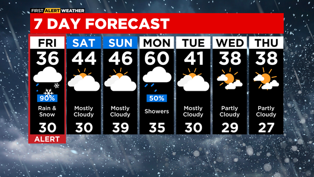
All Winter Storm Warnings have been dropped early as the system quickly moved into Michigan. Highest snow totals ranged from 2 inches to 5.3 inches with most occurring in northwest Indiana.
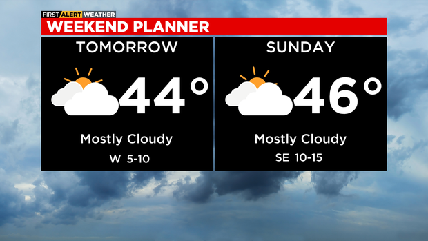
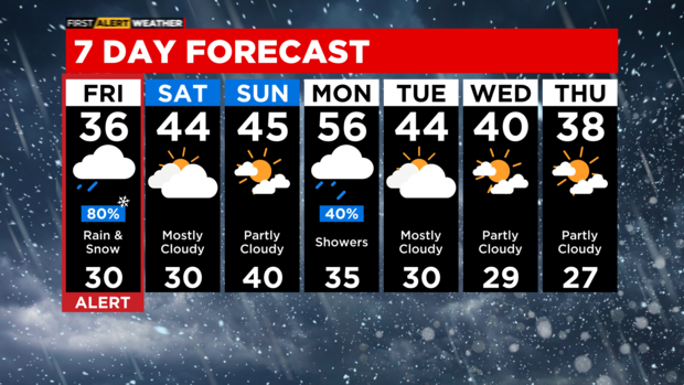
The weekend will feature extra clouds and highs in the upper 40s. Normal high is 42 degrees.
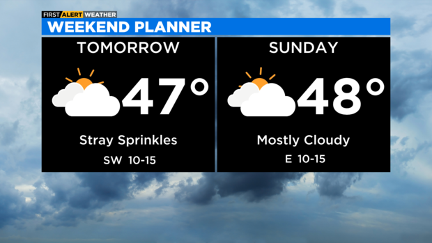
A weak disturbance Saturday will touch off a few afternoon sprinkles. Dry Sunday.
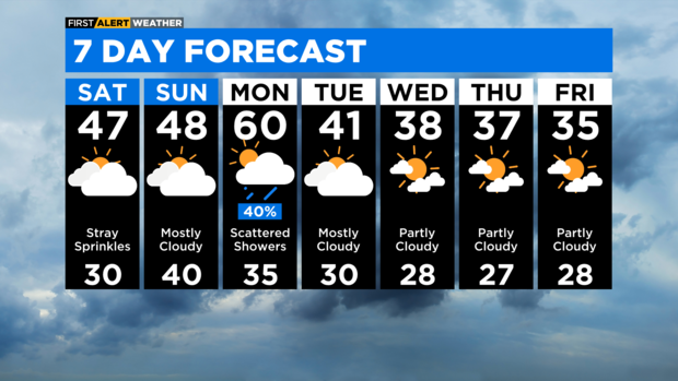
TONIGHT: CHILLY WIND. LOW 30.
SATURDAY: STRAY AFTERNOON SPRINKLES. HIGH 47.
SUNDAY: MOSTLY CLOUDY. HIGH 48.
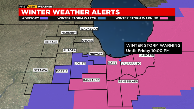
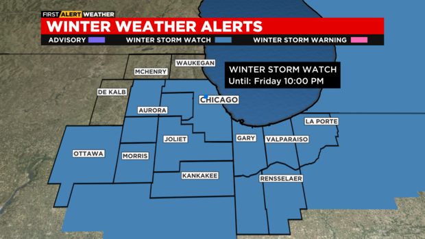
Advisories, warnings canceled
The winter storm warning for Will and Kankakee counties in Illinois, and Northwest Indiana has been canceled. The Winter Weather Advisory for Cook, Grundy, and Will counties has also been called off.
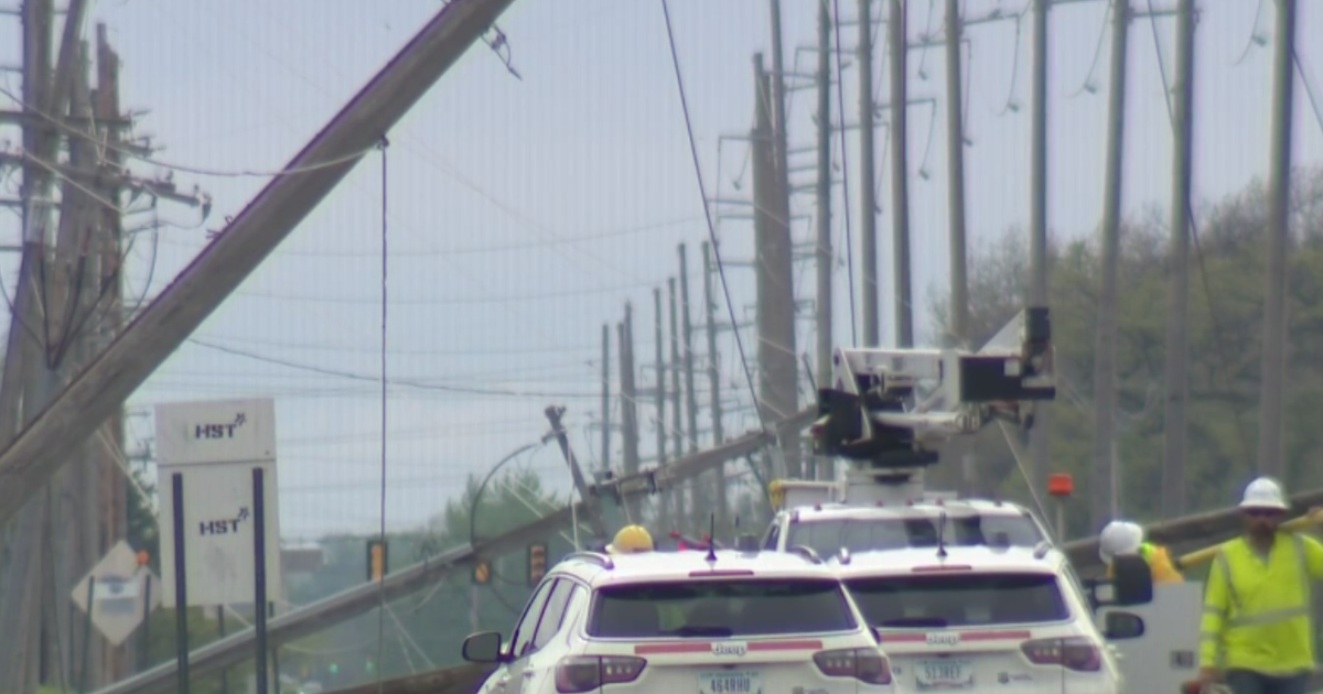
Messy driving conditions on Indiana Toll Road
Chicago Weather Alert:
Chicago Weather Alert: Messy mix on roadways
Stretch of westbound Indiana Toll Road closed due to crash amid snow
The snow is intensifying in the south suburbs and Northwest Indiana, and the roads have become dangerous.
Multiple crashes were reported during the afternoon rush.
A multi-vehicle crash was reported just after 5 p.m. on the Bishop Ford Freeway near the turn to I-80/94. A crash was also reported on 80/94 at Cline Avenue and on I-94 just west of State Road 49 in Indiana.
Most seriously, a crash on the westbound Indiana Toll Road just east of State Road 49, and west of Michigan City Plaza, has the westbound lanes of the toll road between U.S. 421 and SR 49.
Chicago Weather Alert: Dicey conditions on the roads
Chicago Weather Alert: Flood Watch
CBS 2 Chief Meteorologist Albert Ramon has more on the Flood Watch that's been issued.
High winds reported in central Illinois
The National Weather Service is reporting potentially damaging wind gusts across central Illinois.
Gusts upwards of 55 to 65 miles per hour are possible, the NWS said.
The wind is expected into the evening.
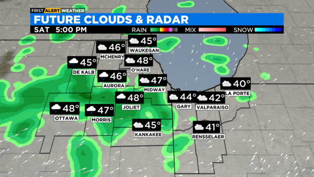
Little to no rain, snow for some parts of Chicago
We're still expecting rain to change to snow, but more likely this will impact Indiana more than Illinois. Parts of the city may see little to no impact. Farther south the impacts will ramp up.
This Afternoon:
Rain changing to snow for NW Indiana. Some snow may be falling in southern Cook County south to Kankakee. This will continue through the evening rush.
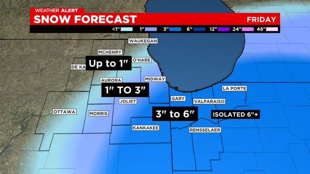
Still expecting 1 to 3" south of Chicago. 3" or more in NWIndiana. (See map).
Tonight:
Snow ends.
Saturday:
Mostly cloudy. High 44.
Mild into next week with Monday bringing 60 and rain.
Winter weather advisory canceled for some areas
The winter weather advisory for central Cook, DuPage and Kendall counties has been canceled.
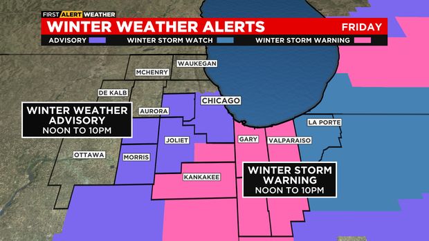
A separate winter weather advisory is in effect for Grundy, Livingston, Ford, southern Cook, northern Will, and southern Will counties in Illinois from 2 p.m. to 10 p.m.
A winter storm warning is also in effect for Kankakee, Iroquois, and eastern Will counties in Illinois, and Lake, Porter, Newton, Jasper, and Benton counties in Indiana from 2 p.m. until 10 p.m. central time.
CBS 2 meteorologists will continue to monitor and provide updates.
OEMC warns drivers ahead of snow
The Chicago's Office of Emergency Management is warning drivers of a slippery afternoon commute. Officials recommend keeping a safe distance when driving.
City deploys snowplows ahead of winter storm
At 6 a.m., the The Department of Streets and Sanitation deployed city snowplows in preparation for snow Friday.
Officials are warning drivers to take caution when commuting, especially Friday night.
You can track the city's snow fleet in real time at chicagoshovels.org.
Strong winds causing hazardous conditions
The National Weather Service is warning residents to prepare for windy conditions.
Wind gusts of 35 to 45 miles per hour could lead to power outages. Some damaging gusts could reach 60 miles per hour.
The NWS said damaging wind gusts are expected between 11 a.m. and 5 p.m.
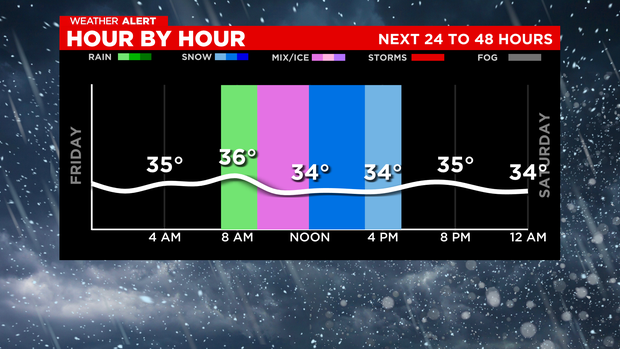
Here's when you can expect rain, snow Friday
Rain and snow is on the way. Here's a timeline for when you can expect winter weather.
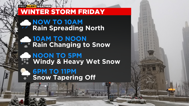
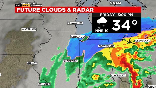
Through 10 a.m., rain from the south will be moving north.
From 10 a.m. to noon, rain is expected to change to snow.
After noon until 5 p.m., heavy wet snow moves in with winds causing a threat of downed branches and power lines.
Snow is expected to taper off starting around 6 p.m.
Winter storm watch canceled for northern Cook, Kane, and LaSalle counties
There are some changes from the National Weather Service.
- The Winter Storm Watch is CANCELED for northern Cook, Kane, and LaSalle counties.
- The timing of the storm in general is now later. The Winter Weather Advisory and Winter Storm Warning for parts of the area both starts at NOON.
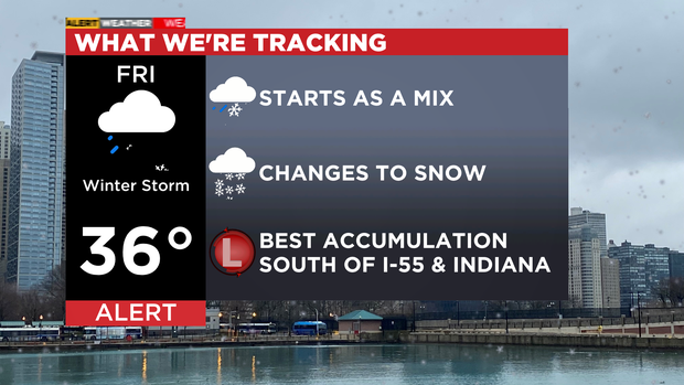
If the storm stays on the current track, we expect rain showers to arrive during the late morning hours changing over to snow after lunch. The best timeframe for snow would be 1 p.m. and 5 p.m.
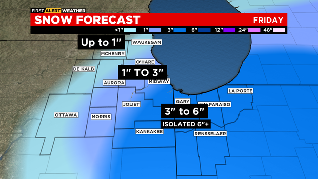
Again, areas south of I-55 to Northwest Indiana are favored for the best snow accumulation.
This is a quick-moving system, with the storm exiting the area early Friday evening.
TONIGHT: CLOUDY. LOW 33.
FRIDAY: RAIN TO SNOW. WINDY. HIGH 36.
SATURDAY: MOSTLY CLOUDY. HIGH 44.
SUNDAY: PARTLY CLOUDY. HIGH 45.
Winter Storm Warning for parts of area
A Winter Storm Warning has been issued for Will and Kankakee counties in Illinois, and Lake, Porter, Jasper, and Newton counties in Indiana.
The warning takes effect at noon Friday and continues until 10 p.m. Friday.
Computer models still disagree on snow totals
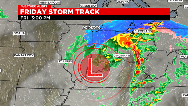
The wall of moisture that will bring us the storm will be focused on a northeasterly span from St. Louis through Cincinnati to Cleveland. But the Chicago area will be close enough as a low-pressure system passes just south of us at noon on Friday.
Colder air will wrap behind the system and change everything to snow for our area.
The computer models still disagree. But we expect Northwest Indiana – from about the Stevenson Expressway south/southeast into Northwest Indiana to see totals of 3 to 6 inches. Totals higher than 6 inches are possible for some parts of Northwest Indiana.

However, one model, the IBM GRAF (Global High-Resolution Atmospheric Forecasting System), has the snowstorm missing the Chicago area altogether – with no snow accumulation seen west of Valparaiso and Rensselaer, Indiana. Those communities would get a mere .3 inch, while LaPorte, Indiana would get .9 inch.
The GFS (Global Forecast System) puts better chances of snow in our area – with 5.2 inches in Kankakee, 9.1 in Valparaiso, and 11.1 in Rensselaer. The snow totals for the more immediate Chicago area are low with this model – Joliet would see 0.8 inch, Midway International Airport 0.7 inch, and O'Hare International Airport 0.5 inch.
The highest potential snow totals for the Chicago area are seen with the European model, which calls for 1.8 inches at O'Hare, 3.6 at Midway. 4/2 at Joliet, 5.8 at Gary and Rensselaer, and 8.1 at LaPorte.
Heavy winds are also expected around the area for the entire area.
The system will move fast and will be gone by 7 p.m. Friday, leaving us for a dry and quiet weekend. But the afternoon rush has a strong chance of dangerous weather.