
Quiet For Now...
A cold dome of high pressure is settling into New England at the moment...lots of bright sun but chilly temps in the lower 40s.
Watch CBS News
A cold dome of high pressure is settling into New England at the moment...lots of bright sun but chilly temps in the lower 40s.
We started the day at 43 degrees and although we've had nothing but sunshine the temp is essentially the same and stands at 42...gusty winds are bringing in much colder air. High pressure will nose in leading to ample sunshine over the next few days with no storms for the rest of the workweek. That same high will settle over us later Wednesday allowing the wind to relax and temps to moderate. In fact, by Thursday we are back up near 50 with the milder air sticking around until Saturday.
If you were up early you know it was a little wild...downpours and gusty wind...but it's much quieter now as the first of two cold fronts has cleared the coast. The air behind the first front is dry and warm and this afternoon will be a sweet one with highs between 65-70 degrees but this Spring-like feel won't last much longer as the second cold front sweeps through temps will drop.
This is going to be one fine day! High pressure is strong and to our south...mild air is flowing in around it's periphery and temps will spike into the upper 50s and lower 60s today under mostly sunny skies. There will be some this cirrus clouds up there from time to time.

Act like a bear and hibernate until tomorrow...that's the easy way out. But if you are tough...and I know many of you are...today will have a Winter feel all day long. Yesterday's arctic front is south of us and the core of the cold is in place...today's highs only in the upper 30s but with the wind will feel like 20s.
Get ready, we may just be in for our first real taste of winter weather.
First off, a heart-felt thank you to all past, present and future veterans...I hope you enjoy this day.
For the first time this season Logan Airport registered a temp of 32 or below and many of the suburbs slipped into the 20s earlier this morning. Although we have unlimited sunshine today it isn't very effective...highs will only manage the middle 40s.
What a stunner yesterday was...highs in the 60s...today 20 degrees colder! A cold front is slipping through New England delivering the coldest air of the season. As it comes through, this morning will be mainly cloudy with some passing showers ( maybe a flurry) then the sun comes busting out for the afternoon but it will be ineffective with a gusty north wind.
Temps are on the rise out ahead of a powerful storm system which will march up to our west during the day tomorrow. As the wind increases today, temps will spike up to the lower 60s. Clouds are in the process of thickening and a few showers will be break out as the warmth arrives this evening. At least it will be mild for the trick-or-treaters. The front will close in tomorrow morning with a gusty line of showers and potential rumbles. The showers may be briefly heavy but the wind will be most noticeable...gusts could top 50 mph in elevated areas and along the South Coast. By the afternoon the front will be offshore and drier air will work in with partial sun breaking out...temps will be incredibly warm climbing into the mid 70s just a couple of degrees shy of a record.
Did you see them? Well, you had to look closely but several communities actually saw their first snowflakes of the season this morning as warmer air aloft interacted with chilly surface air and chilly raindrops along with wet snowflakes resulted. The weak system will slide out of here for the afternoon and skies will brighten up with temps climbing into the lower and middle 50s. There will be zero weather issues at Fenway for Game 6 of the World Series...just chilly temps...falling into the 40s by the end of the game.

A cold front is approaching from the NW right now...out ahead of it, winds are a bit gusty but temps will climb to a mild range of 55-60. Clouds will overspread the area late in the day but this frontal passage should stay dry and rain-free. The front will slide through tonight and temps will fall off to the coldest levels of the season...most spots will be in the 20s by morning.
Good Sunday morning! A band of rain along a cold front is working through this early morning...all wet weather associated with it will be out of here by 9AM and west winds will pick up behind it drying us out nicely for the day. Sunshine will be prevalent along with a few puffy clouds this afternoon, the breeze will be noticeable and temps respectable in the mid to upper 50s.
Enjoy the day folks...temps will climb into the middle and upper 60s, almost 10 degrees above normal. But this is it, as a cold front advances in from the west and sweeps through this evening and ushers in an abnormally chilly airmass. Along the front, a skinny line of showers is marching across the Northeast and may produce a few brief showers later today. Following the frontal passage, cold air will come pouring in and for the foreseeable future temps will hover around or slightly higher than 50 degrees...almost 10 degrees below normal.
A cold front is in the process of washing out across the area and the clouds associated with it will be clearing for sunshine. Without a strong push of cold air behind it temps will actually climb into the lower 70s...more than 10 degrees above normal levels! The clearing won't last long because at the tail end of the front, an area of low pressure has formed and more clouds and showers will work in from the SW later tonight. The low will provide more lift and better dynamics so showers are likely over night and some may be briefly heavy. The low will lift out early tomorrow morning and a murky start will transition into a bright and breezy afternoon with highs again around 70 degrees.
Frontal boundaries are having a very tough time getting through the Northeast...with high pressure locked in place and not much moving in the atmosphere these fronts tend to wash out instead of delivering a shot of cold air. The end result...mild temps and lots of clouds. Another front will work in early tomorrow morning but will also fizzle overhead...slight chance for a shower tomorrow morning followed by brightening and warm temps in the 70s tomorrow afternoon.
No complaints here...we continue to see temps near or slightly above the average and intervals of sunshine with very little rain...I see this trend through the weekend.
While we've been enjoying sunny, crisp October weather, the Mid-Atlantic is receiving wave after wave of rain and wind. A large storm is swirling off the Outer Banks and is in no hurry to move as it's cut-off from the steering currents in the upper atmosphere. The storm is now beginning to drift north and clouds and rain continue to get closer and closer. The clouds will thicken up today and combination of limited sun and onshore winds, it will feel pretty raw.
Between the wind, the downpours and the balmy air, yesterday and last night were pretty wild but the weather has quieted down following the passage of a cold front. Autumn air is now streaming back in...this has cooled us off but also lead to ample sunshine. After sunset, temps will drop fast tonight and will settle into the 30s for some communities tomorrow morning only to recover into the lower 60s tomorrow afternoon under mostly sunny skies. High clouds will begin working in from the south late in the day out ahead of a developing coastal storm.
It's been nearly two full weeks since our last rain drop but that all changes today. A warm front is migrating through the Northeast and the lift associated with, although weak, is generating showers. Clouds will increase this morning with rain showers not far behind. The showers will be scattered but may be briefly heavy and a few will fall around the Sox game this afternoon. The front won't move much over the weekend and we will be on the cooler side of it for the most part. That means a lot of clouds, cool temps in the mid 60s and perhaps a shower or two but the good news is that most of the weekend will be rain-free.

Welcome to the first day of August...errr October. We may be changing the page on the calendar but this fine stretch of weather knows no boundaries and lives on. Our one chance for a big soaking is drifting into the Canadian Maritimes right now...a miss. As it departs to the NE it will open the doors and let Summer-like warmth in for a few days. Highs will range from the 70s today to the 80s tomorrow to around 80 on Thursday. All days will feature plenty of sunshine.
Is this the best month ever or what...we've only had one day with measurable rain in the last two weeks! Heading into the weekend not much will change. High pressure is in charge and although we will have more clouds than sun today the weekend will be loaded up with sunshine and warmer temps in the lower to middle 70s.

Our one chance for substantial rain is disappearing and the dry stretch rolls on. High pressure will be in charge through the weekend with cool nights and seasonably mild days which will include ample sunshine. We'll also have onshore breezes which may throw clumps of clouds our way at times.

Do you recall yesterday? Oh good, then dress the same today...just not the same clothes though. Seriously, not much has changed with high pressure to our NW and low pressure to our NE we continue with mainly sunny skies and seasonably cool temps in the upper 60s.
Not much to complain about these days...sure it's a bit chilly in the morning and the breeze can be somewhat annoying at times...but we are living on easy-street right now with no major changes until perhaps the end of the weekend. We will remain essentially cloudless during this stretch with afternoon highs near 70 degrees and overnight lows in the lower 40s.
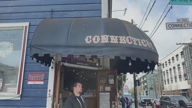
It's a home away from home for Boston fans in San Francisco, and it's where many are stopping in ahead of the New England Patriots facing the Seattle Seahawks in Super Bowl LX on Sunday.

Bad Bunny is set to take the stage at halftime for the 2026 Super Bowl. Here's who else is performing at Super Bowl 60.

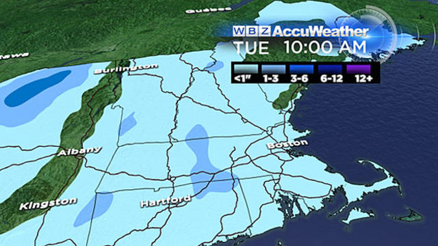
Plowable snow fell in Massachusetts on Saturday. Here's how much your area has gotten.
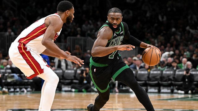
Jaylen Brown had 29 points and Payton Pritchard scored 24 points to help the Boston Celtics beat the Miami Heat 98-96 on Friday night.
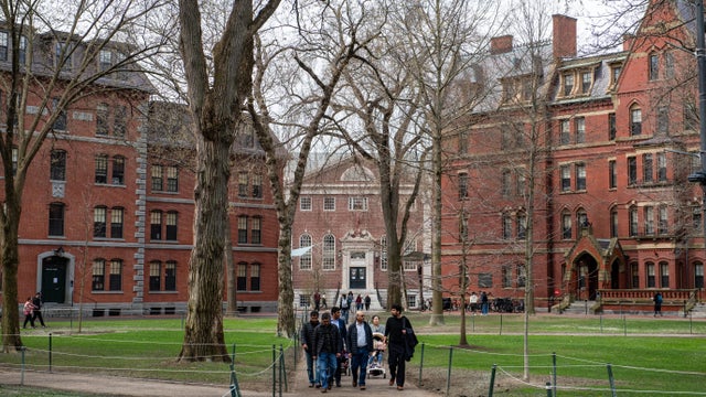
The Pentagon says it will cut ties with Harvard University, ending graduate-level military training, fellowship and certificate programs.
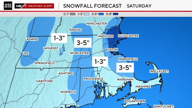
We've got yet another very cold and snowy weekend on tap in Boston. Here's what the weather forecast maps show.
Plowable snow is currently falling in Massachusetts. Here's how much your area has gotten.
It's a home away from home for Boston fans in San Francisco, and it's where many are stopping in ahead of the New England Patriots facing the Seattle Seahawks in Super Bowl LX on Sunday.
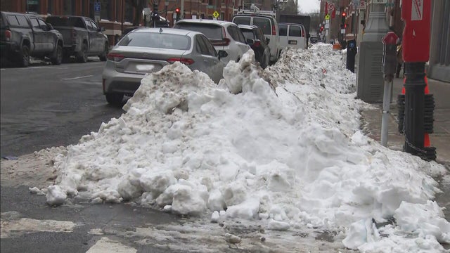
Boston Mayor Michelle Wu is defending the city's snow removal progress nearly two weeks after the storm hit.

Patriots fans will have the memories for a lifetime after traveling for Super Bowl LX.

There's a new drug that can help early morning shift workers stay awake and alert, a study out of Boston found.

As millions of Americans struggle with paying for health care, doctors and health experts discuss how medical care is being eroded by insurers denying necessary tests and treatment, making it "more difficult to be healthy in the United States."

Flu cases are rising rapidly, especially among kids in Boston, where hospitalizations of children under five have increased 150% over the last two weeks.

Four children have died from the flu in Massachusetts so far this season, public health officials say.

Fewer people in Massachusetts are getting their seasonal flu and COVID vaccinations as the number of respiratory infections in the state continues to rise.
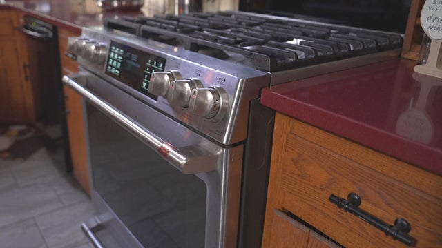
After I-Team reports about a Foxboro woman's frustration with her GE gas range, the company has agreed to give her a refund.
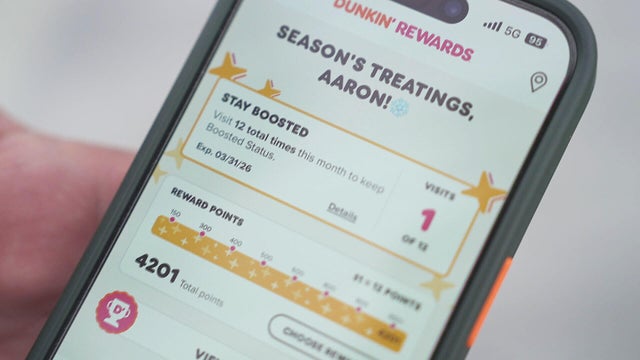
It took Aaron Braun years to get more than 93,000 Dunkin' rewards points, but after a policy change he's left with a fraction of that.

In the last three years, the Better Business Bureau has received thousands of complaints about GE.
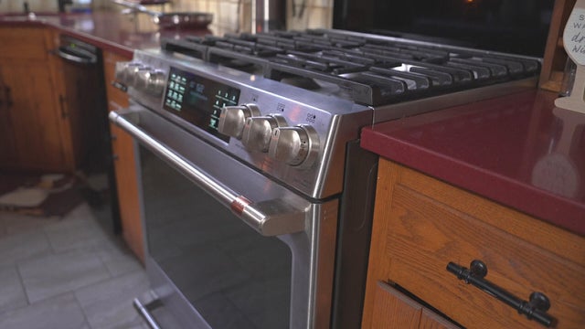
A home baker from Foxboro, Massachusetts is frustrated that the pricy oven she bought from GE wasn't working properly. Attempts to fix it failed.

Eight states have laws making police body cameras mandatory. Massachusetts isn't one of them.

Both the Trump and Healey administrations are using government websites to blame each other for the shutdown.

Which party stands to take more of the blame from voters for the government shutdown? Here's what a new poll says.

A UNH Survey Center/Granite State poll shows John Sununu crushing Scott Brown by 23 points among likely primary voters in New Hampshire.

Seth Moulton said he's running against Sen. Ed Markey because "our party leaders are clinging to that old playbook."

Maine Governor Janet Mills' run for Senate comes with an unusual promise - she will only serve one six-year term.

Raising Cane's claims a Boston landlord has threatened to evict one of its locations in the Back Bay because the restaurant "smells like chicken fingers."
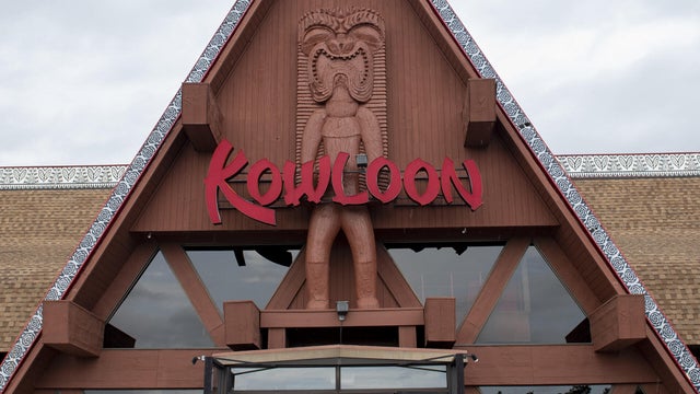
The Kowloon is coming to Revere Beach.
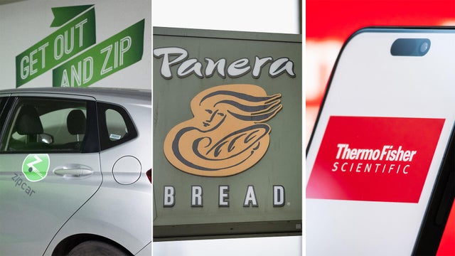
Panera, Zipcar and Thermo Fisher are all closing facilities or offices in Massachusetts.
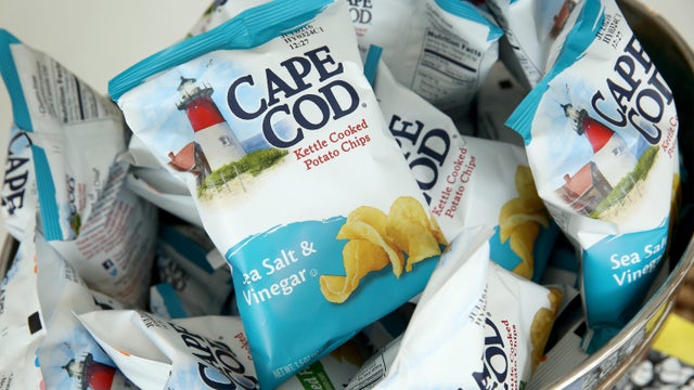
Cape Cod potato chips will no longer be made on Cape Cod as of this spring.

Time Out Market Boston, a food hall that opened in the Fenway neighborhood in 2019, won't be closing after all.

Just steps from the water's edge along Lake Winnipesaukee, a spectacular estate mixes modern architecture with breathtaking views.

An innovative craft winery located in downtown Meredith, New Hampshire, Hermit Woods is taking a different approach to winemaking.

Located on the water's edge along New Hampshire's Lake Winnipesaukee, Mill Falls blends elegant luxury with spectacular vistas.

Kohler Store by Supply New England and an interior designer showcases how beauty and functionality can breathe new life into a project.

James Beard-nominated pastry chef and co-founder of Bakey in Boston gives insight on how to make his world-famous babka.
Bad Bunny is set to take the stage at halftime for the 2026 Super Bowl. Here's who else is performing at Super Bowl 60.
Jaylen Brown had 29 points and Payton Pritchard scored 24 points to help the Boston Celtics beat the Miami Heat 98-96 on Friday night.

Jayson Tatum is not ready to come back yet this season, Boston Celtics president Brad Stevens said Friday.

Eager to attend this year's Super Bowl? Be prepared to pay four figures for the ticket alone — and those are the cheap seats.

While the Seahawks and Patriots will face off on the field, the NFL cities look to outshine each other.
Raising Cane's claims a Boston landlord has threatened to evict one of its locations in the Back Bay because the restaurant "smells like chicken fingers."
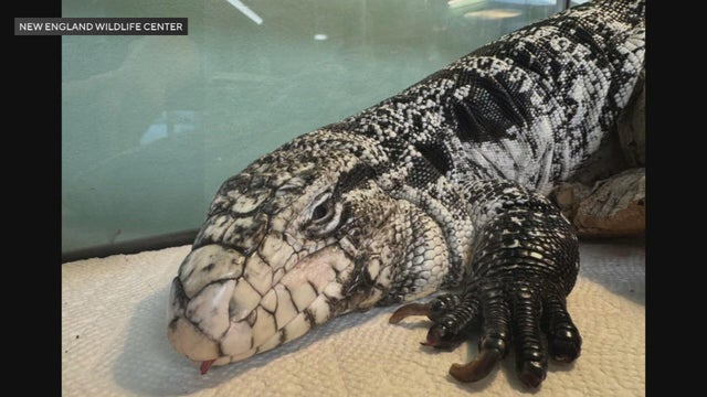
A tegu lizard was found buried beneath the snow in Providence, Rhode Island.

A gathering of North Atlantic right whales off Massachusetts over the weekend appears to have set a new monthly record.

A rocketship on a downtown Boston roof is part of the new Winteractive 2026 public art installation.

The overpowering scent of Dunkin' donuts in the air has some Haverhill residents complaining.