
Following The Path Of Destruction From Tornadoes In Western Mass.
The third largest tornado to occur in Massachusetts since the Worcester Tornado in 1953 will also be noted for the length of its damage path - approximately 39 miles.
Watch CBS News
The third largest tornado to occur in Massachusetts since the Worcester Tornado in 1953 will also be noted for the length of its damage path - approximately 39 miles.

The National Weather Service has declared one of Wednesday's tornadoes in Massachusetts an EF-3, the third highest ranking in terms of damage, with wind speeds from 136-to-165 miles per hour.
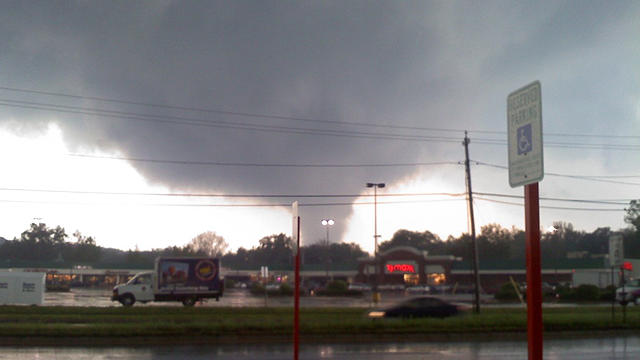
When the storm hit Westfield, many residents were still on the roads returning from work. The Mayor says timing of the storm may have been a good thing.

It's still not clear how powerful Wednesday's tornadoes measured on the Enhanced Fujita Scale, but one expert said the damage they left behind is "impressive."

A strong storm system that has been responsible for the severe weather outbreak over the South-Central and Southeast United States will make its way into Southern New England tonight bringing with it heavy rainfall, strong to damaging winds and the potential for minor coastal flooding at the time of high tide late Saturday Evening through early Sunday Morning..

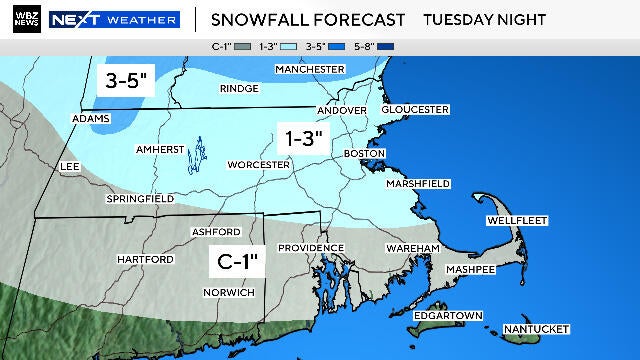
Afternoon weather discussion of the potential for a rain/snow mix to end the week.

One year after the devastating March storms and subsequent flooding, victims are still cleaning up and rebuilding.
Behind the departing low, some early sunshine this morning, but as the ground warms clouds and the wave passes through expect more clouds to rotate through, as well as the slight risk for a few passing light showers or sprinkles. Behind the short wave, skies should be breaking this afternoon for some increasing sunshine with a breezy west wind. Highs will be in the 40's in the clouds, Lwr 50's in the sunshine towards the coastal plain. Most of the sun today will be found in the south...yet most should be clearing as we head towards evening.
Upper level winds from the SW are advecting a warm balmy airmass up the east coast. But cooler air is charging back into the eastern half of the country so This warm balmy air is being lifted up, cooled, condenced into steady to heavy rains which are extending from Vermont to the Carolinas today.
Clouds will be on the increase tonight. These clouds will trap in todays warmth. This along with south winds should help to keep temps pleasantly mild through the overnight in the 40's. Temps will be climbing right back into the 50's tomorrow as warmer air remains in place along the eastern seaboard ahead our approaching rainfall.
Plenty of clouds are locked in for the weekend...but southerly winds will be blowing in the feel of spring!
The snow is really winding down in intensity this morning. this trend will continue as dry air from the midlevels moves in. Plenty of low clouds will remain locked in with light NE winds with the potential for scattered light rain/snow showers at the coast with drizzle. Breaks of sun will be possible out west in the afternoon away form the marine air. Temps will recover this afternoon with some of the snow melting with temps back into the 30's to near 40 in SE MA.
Winds have diminished as weak high pressure sits near us today and moving through the mid-Atlantic states. Sunshine this morning with increasing high to mid level clouds this afternoon ahead of our next disturbance. Highs will be cooler than normal in the lwr-mid 30's.
Clouds have moved in this morning ahead of a warm front. This front is the leading edge of some warmer air which will move in for Valentine's day. Along this front is a vortmax which will slide through SNE during the midday and afternoon. A line of snow showers is pushing through eastern NY and and enter the Berkshires, CT, and S. VT later this morning and will move east during the afternoon. A light coating to 1" is possible in the western hills...otherwise most of us have the chance of a passing flurry or snow shower this afternoon.
Clouds are on the increase ahead of a cold front which will push through New York then New England by the end of the day. Winds will pick up out of the SW ahead of this front with gusts to 30 mph. After a cool start, highs will climb into the mid-upper 30's with the Cape edging near 40 this afternoon.
Talk about a Super Sunday! So nice outside. In fact this is the warmest we have been since January 2nd when we reached 51 degrees. Nice to finally thaw a bit. Highs today will climb to 40 to 46 degrees in the sunshine and diminishing wind behind our departing low whose low pressure has dropped down to 981 mb over Nova Scotia.
Clouds rolling through this morning as another shortwave pushes through. Scattered flurries are possible with the passage of an arctic front which will be off the coast this afternoon with clearing skies later in the day. Cold air settles in overnight with lows in the single digits and teens, NW valleys below zero. Arctic sunshine in place for Monday with highs in the teens and Lwr 20's.
Arctic air is on the move today. The Arctic front currently in Northern New England will push off the coast this afternoon. Ocean effect snowshowers for the Outer Cape could provide some minor accumulations...D-2". Significant cold air will settle into the region overnight with clear skies and diminishing wind. Lows drop to 0 at the coast to -20 to -25 in NW sheltered valleys. Many suburbs outside Boston drop down to -5 to -15 by dawn tomorrow

The newly fallen snow is adding to the chill this morning in the single digits and teens. 850 mb temps near -15C will help keep temps in the teens and lwr 20's today. We are tracking an arctic front currently in place ver the Great lakes and Canadian border. This will approach from the west tonight with increasing clouds and a chance of a few flurries by dawn. Once this front pushes off the coast tomorrow..the cold arctic air will begin to plunge into the region with the coldest air to be found Sunday Night-Early Tuesday.
The coldest air we have seen since last January is in place this morning. High pressure is providing plentiful sunshine with high clouds streaming eastward in advance of a weak upper level disturbance which will provide light snow & snow showers to the region tonight. High temps will rebound into the mid 20's for most by this afternoon...with the Cape & Islands able to climb into the lwr 30's with a light SW wind.
Round one( the Norlun Trough) is moving through Metrowest in a weakened state this morning. It is still providing moderate bursts of snowfall, reducing visibility down to mile at times...and enough for a general coating to 1" of snow. Roads are mostly wet...but a slushy accumulation is gathering in spots
Heavy Snow and Wind will lash New England in a powerful winter storm late Sunday Afternoon through Monday. Over a foot of snow is possible in many areas with peak winds gusting over 60 mph at the coast.

At this point there are still more questions than answers in regards to the upcoming storm. We are still playing a game of "Wait and See". Not just what the models are going to say..but also how the actual weather is going to behave.
The final batch of light snow is pushing from Southern Maine into Eastern Mass for the late morning and midday. Light snow will be tapering off this afternoon...but it could take the Cape and islands most of the day for the snow to finally end. Temps will be warming into the upper 30's, so some of this light snow at the coast may start to mix with a light rain.

Four Massachusetts State Police instructors have been charged following an investigation into the 2024 death of state police recruit Enrique Delgado-Garcia.
Before we start the "great snow melt of 2026," there is another storm system in the weather forecast for the Boston area.

The Boston Red Sox acquired third baseman Caleb Durbin in a trade with the Milwaukee Brewers.
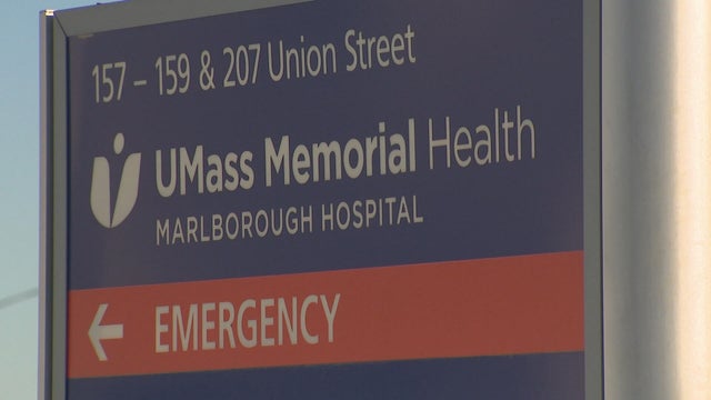
Dozens of patients being treated at UMass Memorial Medical Center were left without heat for several hours during freezing temperatures after the boiler system was flooded on Sunday night.
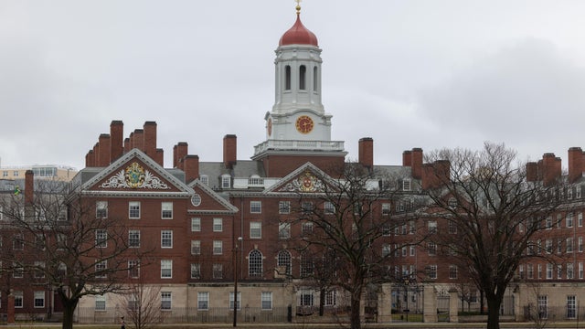
A faculty committee at Harvard University has proposed limiting the number of A's awarded to students.
Four Mass. State Police instructors have been charged following an investigation into the 2024 death a state police recruit.
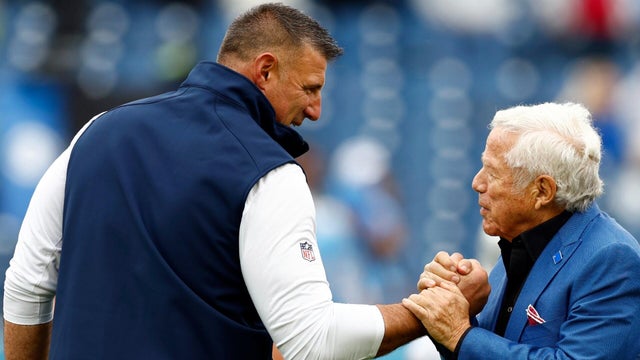
The Patriots season has come to an end after a loss in the Super Bowl. Here is a look at what comes next, including free agency, the NFL Draft, and the 2026 schedule.
Before we start the "great snow melt of 2026," there is another storm system in the weather forecast for the Boston area.

Mike Vrabel said it's critical for his team to learn from a blowout Super Bowl loss.

New England Patriots quarterback Drake Maye was emotional following his team's Super Bowl loss.

There's a new drug that can help early morning shift workers stay awake and alert, a study out of Boston found.

As millions of Americans struggle with paying for health care, doctors and health experts discuss how medical care is being eroded by insurers denying necessary tests and treatment, making it "more difficult to be healthy in the United States."

Flu cases are rising rapidly, especially among kids in Boston, where hospitalizations of children under five have increased 150% over the last two weeks.

Four children have died from the flu in Massachusetts so far this season, public health officials say.

Fewer people in Massachusetts are getting their seasonal flu and COVID vaccinations as the number of respiratory infections in the state continues to rise.

After I-Team reports about a Foxboro woman's frustration with her GE gas range, the company has agreed to give her a refund.
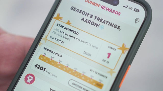
It took Aaron Braun years to get more than 93,000 Dunkin' rewards points, but after a policy change he's left with a fraction of that.

In the last three years, the Better Business Bureau has received thousands of complaints about GE.

A home baker from Foxboro, Massachusetts is frustrated that the pricy oven she bought from GE wasn't working properly. Attempts to fix it failed.

Eight states have laws making police body cameras mandatory. Massachusetts isn't one of them.

Both the Trump and Healey administrations are using government websites to blame each other for the shutdown.

Which party stands to take more of the blame from voters for the government shutdown? Here's what a new poll says.

A UNH Survey Center/Granite State poll shows John Sununu crushing Scott Brown by 23 points among likely primary voters in New Hampshire.

Seth Moulton said he's running against Sen. Ed Markey because "our party leaders are clinging to that old playbook."

Maine Governor Janet Mills' run for Senate comes with an unusual promise - she will only serve one six-year term.
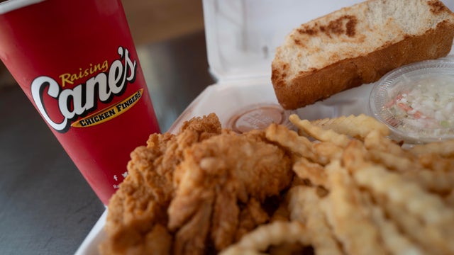
Raising Cane's claims a Boston landlord has threatened to evict one of its locations in the Back Bay because the restaurant "smells like chicken fingers."
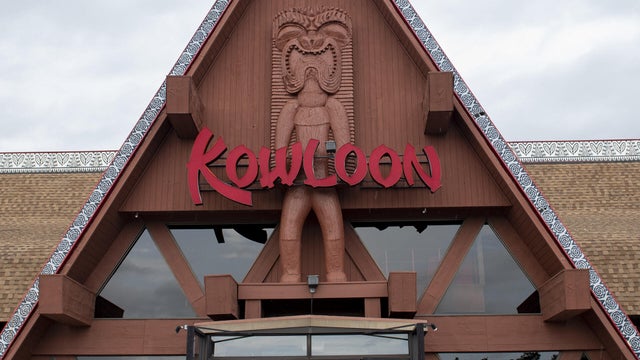
The Kowloon is coming to Revere Beach.

Panera, Zipcar and Thermo Fisher are all closing facilities or offices in Massachusetts.
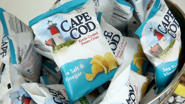
Cape Cod potato chips will no longer be made on Cape Cod as of this spring.

Time Out Market Boston, a food hall that opened in the Fenway neighborhood in 2019, won't be closing after all.

Just steps from the water's edge along Lake Winnipesaukee, a spectacular estate mixes modern architecture with breathtaking views.

An innovative craft winery located in downtown Meredith, New Hampshire, Hermit Woods is taking a different approach to winemaking.

Located on the water's edge along New Hampshire's Lake Winnipesaukee, Mill Falls blends elegant luxury with spectacular vistas.

Kohler Store by Supply New England and an interior designer showcases how beauty and functionality can breathe new life into a project.

James Beard-nominated pastry chef and co-founder of Bakey in Boston gives insight on how to make his world-famous babka.
The Boston Red Sox acquired third baseman Caleb Durbin in a trade with the Milwaukee Brewers.
The Patriots season has come to an end after a loss in the Super Bowl. Here is a look at what comes next, including free agency, the NFL Draft, and the 2026 schedule.
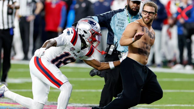
When a fan ran onto the field during the Super Bowl, Patriots player Kyle Williams ran to track him down.
Mike Vrabel said it's critical for his team to learn from a blowout Super Bowl loss.

New England Patriots quarterback Drake Maye was emotional following his team's Super Bowl loss.
Raising Cane's claims a Boston landlord has threatened to evict one of its locations in the Back Bay because the restaurant "smells like chicken fingers."
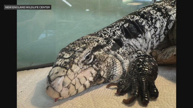
A tegu lizard was found buried beneath the snow in Providence, Rhode Island.
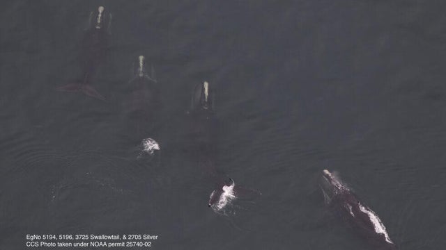
A gathering of North Atlantic right whales off Massachusetts over the weekend appears to have set a new monthly record.
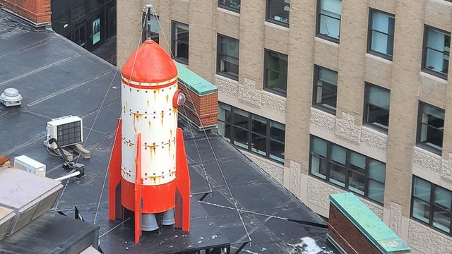
A rocketship on a downtown Boston roof is part of the new Winteractive 2026 public art installation.

The overpowering scent of Dunkin' donuts in the air has some Haverhill residents complaining.