
Ski Report For Week Ending Jan. 14
Martin Luther King weekend and new snow will certainly mean longer lines, but the conditions will make it well worth the wait.
Watch CBS News
Martin Luther King weekend and new snow will certainly mean longer lines, but the conditions will make it well worth the wait.

Round one( the Norlun Trough) is moving through Metrowest in a weakened state this morning. It is still providing moderate bursts of snowfall, reducing visibility down to mile at times...and enough for a general coating to 1" of snow. Roads are mostly wet...but a slushy accumulation is gathering in spots

WBZ's Joe Joyce's ski report for week ending Jan. 7, 2011.
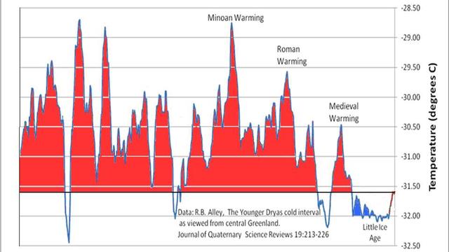
I think both sides provide very convincing arguments and data to support their point of view. It is a fascinating topic...and an evolving science which needs debate and discussion to be open...not sequestered.

Just like in a basketball game, suddenly this winter has gone on the offensive and is going into a full court press. You may not know it yet..but the weather is starting to line up for plenty of cold with the chance for a few snowstorms before the month is through.
Colder air will wait until tonight to finally push in. Plenty of low clouds and fog this morning. Visibilities are gradually starting to improve after a very murky start. Scattered light showers and sprinkles have been pushing through from time to time. Temps have started in the 40's...and that is just about where they will remain today
High pressure off the Mid-Atlantic coast is giving us great weather to start off the year 2011. A mild start with Plenty of sunshine this morning with light SW winds at the surface will allow temps to climb into the Lwr 50's...and may even climb into the mid 50's in a few areas if the sun holds strong through the afternoon.
we will have to watch for snow to quickly push into southern New England quickly by afternoon. I am expecting 2-5" to be on the ground by sunset with snowfall and wind quickly becoming heavy into the evening

Heavy Snow and Wind will lash New England in a powerful winter storm late Sunday Afternoon through Monday. Over a foot of snow is possible in many areas with peak winds gusting over 60 mph at the coast.

At this point there are still more questions than answers in regards to the upcoming storm. We are still playing a game of "Wait and See". Not just what the models are going to say..but also how the actual weather is going to behave.
The final batch of light snow is pushing from Southern Maine into Eastern Mass for the late morning and midday. Light snow will be tapering off this afternoon...but it could take the Cape and islands most of the day for the snow to finally end. Temps will be warming into the upper 30's, so some of this light snow at the coast may start to mix with a light rain.
The snow will ease up this evening in intensity...light snow/flurries..Heavier west of Boston...but watch for another band of heavy snow to slide down the coast early tomorrow just before dawn. It will be snowing tomorrow morning at the coast and this could last until 9-10 AM...with additional minor accumulations....but low visibility..and just a few inches can make driving hazardous from the Cape to the South Shore. Expect a slow go.

Expect some snow tonight, a clear Christmas, and then a possible storm Sunday.
Steady snow through midnight...but a lesser intensity through the overnight with snow showers. It could very well still be snowing at the coast for the morning commute...in areas which are seeing the heaviest snow tonight. Expect more delays/accidents and spin outs as people practice their winter driving skills
Clouds are quickly filling in today with skies becoming cloudy. These clouds will thicken and lower into the evening hours. N0rthern New England is looking at a nice day with increasing afternoon cloudiness
The week that was in forecasting is gone now. What we are left with is high confidence of a storm tracking far enough off the coast to have little impact for our region. In fact, I am calling for a great weekend...but also cautious to see if this storm has any more tricks up it's sleeve.
Simply put...On Tuesday the 21st, A Full Moon Occurs on the Winter Solstice with a Total Lunar Eclipse. This will never again occur in your lifetime. Awesome.
A cold front is pushing through New England tonight. An upper level short wave is providing enough instability and lift that showers are developing along this boundary. On the cooler side of the front, light snow has developed in Pittsfield, Springfield, Orange, Hartford, Windsor Locks, and Gardner. Worcester will be changing over to snow this evening as well. In fact this upper level disturbance has the potential to provide scattered rain/snow showers across much of the region as the front approaches the coast. As temperatures fall behind the front, there is the potential for black ice to develop after midnight
Focus will turn to bouts of Heavy rain and strong winds which will be developing today. Strong low level jet wind of 70-100 mph will be racing above our heads this afternoon and evening. Some of these winds will mix down in heavier downpours..especially at the coast and hilly terrain.
weak high pressure providing enough subsidence and sinking air to provide ample sunshine in southern new England with a milder SW wind at the surface. This will return our temps to a more seasonal airmass of 40-45. A pleasant afternoon for most. There are more clouds in Northern New England with a cold front draped across the Canadian border. These clouds will remain in place for the rest of the day.
This week provided many northern mountains their first substantial snowfall of the season.
Arctic air in place today-tonight-through tomorrow keeping temperatures way below from the normal high this time of year year. This is an airmass more typical in the dead of winter...even then it would be chilly! Highs today are 30-35, but winds gusting over 30 are making temps feel like the teens and Lwr 20's
Certainly more clouds out there today compared to yesterday...but still an overcast thin enough at times to provide some partial sun. A lighter NW wind with considerable cloudiness will keep temps mostly in the 30's today. Some spots will average close to 10 degrees below normal.
Not one, but two snowstorms will take aim at northern New England in the next few days. This is not a pattern conducive to bring snow to southern New England, but north facing slopes in the north country will find their first significant snowfall of the season.
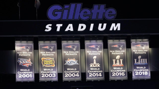
The New England Patriots are back in the Super Bowl once again in 2026, hoping to add another ring to their list of wins. Here's a look back at their appearances, losses, how many they've won, and more.
Not sure where to watch the 2026 Super Bowl live? There are multiple ways to watch the game for free today. Here's how.
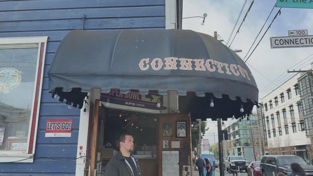
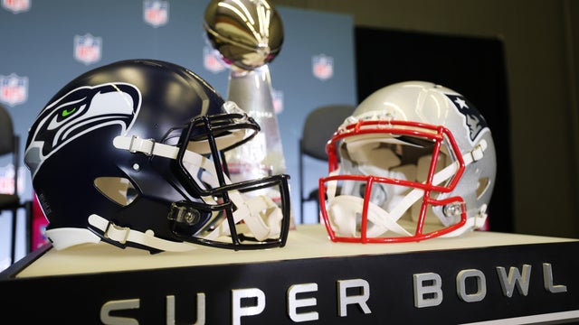
It's a home away from home for Boston fans in San Francisco, and it's where many are stopping in ahead of the New England Patriots facing the Seattle Seahawks in Super Bowl LX on Sunday.

Bad Bunny is set to take the stage at halftime for the 2026 Super Bowl. Here's who else is performing at Super Bowl 60.
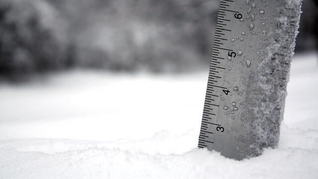
Plowable snow fell in Massachusetts on Saturday. Here's how much your area has gotten.
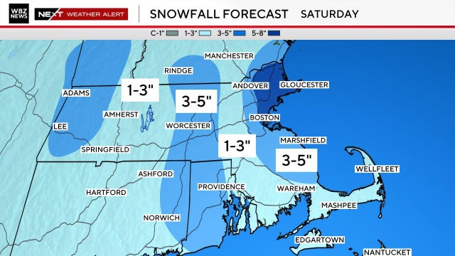
We've got yet another very cold and snowy weekend on tap in Boston. Here's what the weather forecast maps show.
Plowable snow is currently falling in Massachusetts. Here's how much your area has gotten.
It's a home away from home for Boston fans in San Francisco, and it's where many are stopping in ahead of the New England Patriots facing the Seattle Seahawks in Super Bowl LX on Sunday.
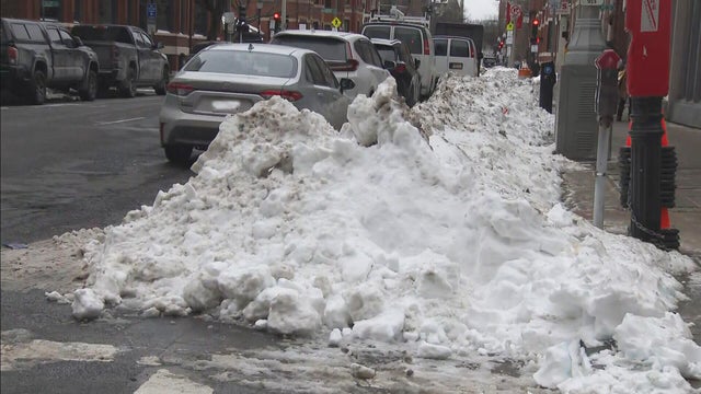
Boston Mayor Michelle Wu is defending the city's snow removal progress nearly two weeks after the storm hit.
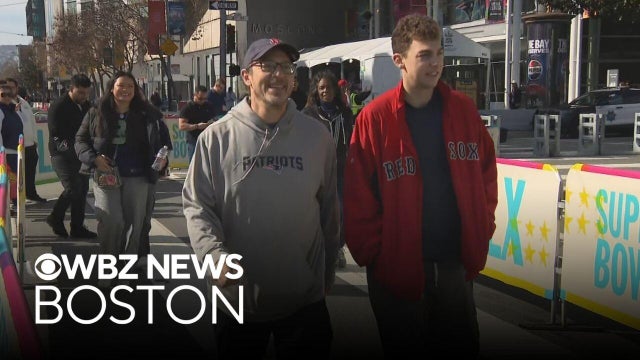
Patriots fans will have the memories for a lifetime after traveling for Super Bowl LX.

There's a new drug that can help early morning shift workers stay awake and alert, a study out of Boston found.

As millions of Americans struggle with paying for health care, doctors and health experts discuss how medical care is being eroded by insurers denying necessary tests and treatment, making it "more difficult to be healthy in the United States."

Flu cases are rising rapidly, especially among kids in Boston, where hospitalizations of children under five have increased 150% over the last two weeks.

Four children have died from the flu in Massachusetts so far this season, public health officials say.

Fewer people in Massachusetts are getting their seasonal flu and COVID vaccinations as the number of respiratory infections in the state continues to rise.

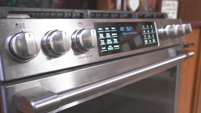
After I-Team reports about a Foxboro woman's frustration with her GE gas range, the company has agreed to give her a refund.
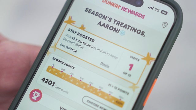
It took Aaron Braun years to get more than 93,000 Dunkin' rewards points, but after a policy change he's left with a fraction of that.
In the last three years, the Better Business Bureau has received thousands of complaints about GE.
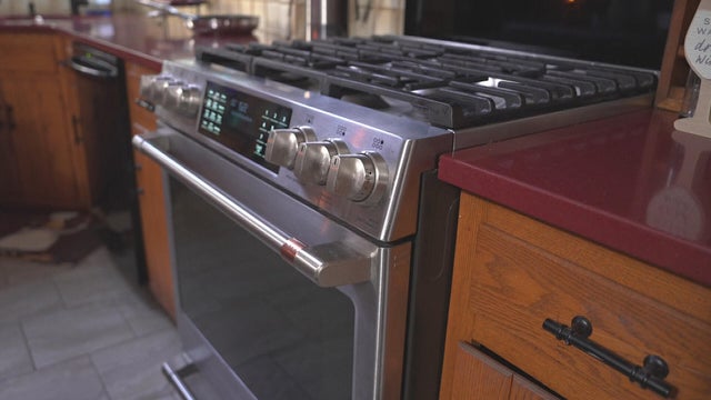
A home baker from Foxboro, Massachusetts is frustrated that the pricy oven she bought from GE wasn't working properly. Attempts to fix it failed.
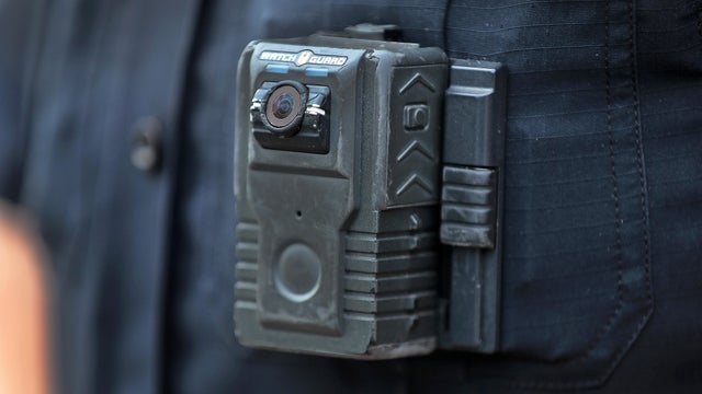
Eight states have laws making police body cameras mandatory. Massachusetts isn't one of them.

Both the Trump and Healey administrations are using government websites to blame each other for the shutdown.

Which party stands to take more of the blame from voters for the government shutdown? Here's what a new poll says.

A UNH Survey Center/Granite State poll shows John Sununu crushing Scott Brown by 23 points among likely primary voters in New Hampshire.

Seth Moulton said he's running against Sen. Ed Markey because "our party leaders are clinging to that old playbook."

Maine Governor Janet Mills' run for Senate comes with an unusual promise - she will only serve one six-year term.
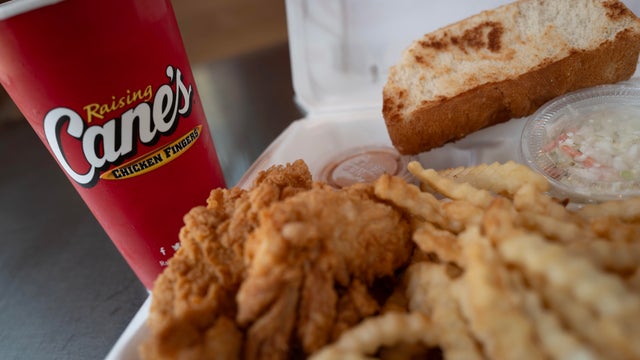
Raising Cane's claims a Boston landlord has threatened to evict one of its locations in the Back Bay because the restaurant "smells like chicken fingers."
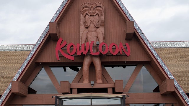
The Kowloon is coming to Revere Beach.
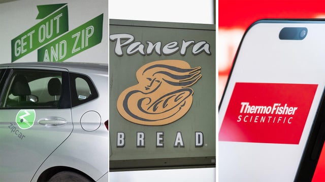
Panera, Zipcar and Thermo Fisher are all closing facilities or offices in Massachusetts.
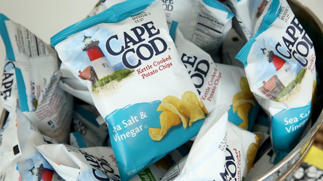
Cape Cod potato chips will no longer be made on Cape Cod as of this spring.
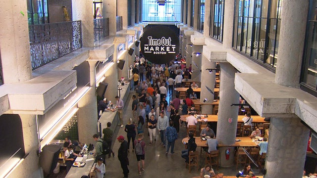
Time Out Market Boston, a food hall that opened in the Fenway neighborhood in 2019, won't be closing after all.

Just steps from the water's edge along Lake Winnipesaukee, a spectacular estate mixes modern architecture with breathtaking views.

An innovative craft winery located in downtown Meredith, New Hampshire, Hermit Woods is taking a different approach to winemaking.

Located on the water's edge along New Hampshire's Lake Winnipesaukee, Mill Falls blends elegant luxury with spectacular vistas.

Kohler Store by Supply New England and an interior designer showcases how beauty and functionality can breathe new life into a project.

James Beard-nominated pastry chef and co-founder of Bakey in Boston gives insight on how to make his world-famous babka.
The New England Patriots are back in the Super Bowl once again in 2026, hoping to add another ring to their list of wins. Here's a look back at their appearances, losses, how many they've won, and more.
Not sure where to watch the 2026 Super Bowl live? There are multiple ways to watch the game for free today. Here's how.
Bad Bunny is set to take the stage at halftime for the 2026 Super Bowl. Here's who else is performing at Super Bowl 60.
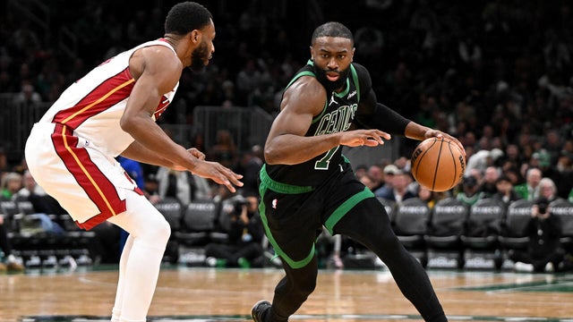
Jaylen Brown had 29 points and Payton Pritchard scored 24 points to help the Boston Celtics beat the Miami Heat 98-96 on Friday night.
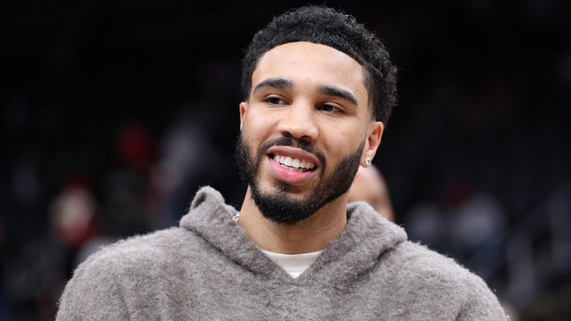
Jayson Tatum is not ready to come back yet this season, Boston Celtics president Brad Stevens said Friday.
Raising Cane's claims a Boston landlord has threatened to evict one of its locations in the Back Bay because the restaurant "smells like chicken fingers."
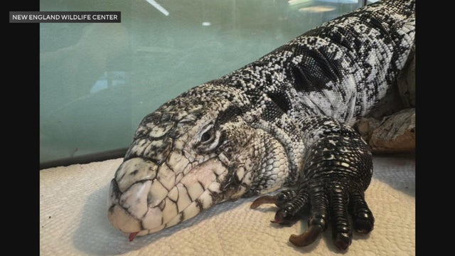
A tegu lizard was found buried beneath the snow in Providence, Rhode Island.
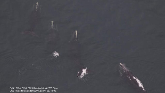
A gathering of North Atlantic right whales off Massachusetts over the weekend appears to have set a new monthly record.
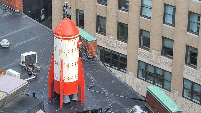
A rocketship on a downtown Boston roof is part of the new Winteractive 2026 public art installation.
The overpowering scent of Dunkin' donuts in the air has some Haverhill residents complaining.