
Lack Of Rain Takes Toll On Local Lakes
The dry weather is impacting habitats for wildlife and the use of lakes for recreation.
Watch CBS News
The dry weather is impacting habitats for wildlife and the use of lakes for recreation.

The Easter Bunny took a break from its busy schedule to stop by the WBZ-TV News Sunday morning.

A deck of mid level clouds is pushing through east MA this AM from Northern New England. Brighter skies will be found inland. These are clouds on the move...so sun will return before the AM through...but All of us will begin to turn cloudy this afternoon. Breezy NW winds will keep temps in the Lwr 50's. Winds turn onshore this afternoon at the coast which will keep temps in the 40's at the beaches...with clouds and a breeze...definitely chilly.
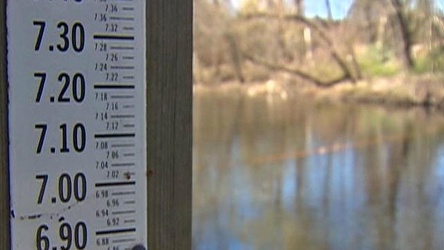
The lack of heavy snow or rain from our record warm and dry winter is causing river levels to fall at an alarming rate for this time of year.
It is amazing what sunshine and a South wind can do this time of year! After this frost start, temps are quickly on the rise this morning and will be climbing to 50-55 degrees by this afternoon! About 10 degrees warmer than Saturday...still it should remain slightly cooler at the coast from Boston to the Cape with more of a light SE wind keeping temps in the 40's to near 50.
Clouds will begin to break for some increasing PM sun. SNE should hold onto the clouds for much of the day...but look for late day breaks of sun to develop around 5 PM. Temps will be chilly today in the 30's...and climb to near 40-45 by this afternoon as we dry out.

Local farmers say that fruit trees are about 3-4 weeks ahead of schedule and are now in danger of being killed.
A damp start to Sunday with a batch of showers...Light rain and drizzle.. associated with a weak short wave pushing through which is helping to provide the initial lift for the morning hours. The cut-off low, which has taken eight days to move through the country making all kinds of weather headlines, is finally beginning to push off the coast as it rides well south of New England. Still just enough lift may be in place that we could still see a few lingering light showers and drizzle into the afternoon, especially along the coast with light onshore East winds.
A deck of mid-level clouds is moving through with NW winds aloft. This is making for a mostly cloudy day across much of the region...but there are areas with thinner clouds seeing a good amount of sunshine as well. A variably cloudy sky with highs climbing to 60+ inland, 50's in eastern MA...Upper 40's & Lwr 50's at the coast. Saturday is the pick of the weekend. Brighter skies in SNE. Enjoy!
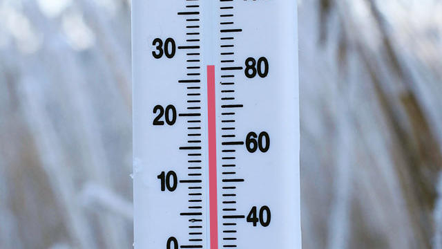
This winter was one of the warmest on record, but now that spring is here, many are wondering how long this warm weather will last. Historically, warm winters like this can be followed by mild springs.
Awesome weather for the St. Patrick's day Parades in South Boston, Scituate and Abington. Bright sunshine with SW winds 10-20 mph will push temps into the 60's nearing 70 this afternoon. With High pressure parked off the coast, This will direct even warmer air into Northern and Central New England, so places like SNH and Northern & Western MA will climb to 70-75 degrees. Records will be broken from Concord, NH to Worcester MA... with Boston's record of 70 degrees in 2011 in jeopardy as well.
A deck of low- mid level clouds is slowing down the hopes for good weather on St Patrick's day. Light onshore winds from the NE/SE will keep it quite chilly at the coast near 50 or slightly above.
Near record warmth is likely today with a big upper level ridge along the east coast providing sunshine with highs climbing into the 60's nearing 70.
High pressure in place across the mid Atlantic is pulling offshore and will begin to wrap in a breezy SW wind today and start the warm up with highs climbing into the 50's.
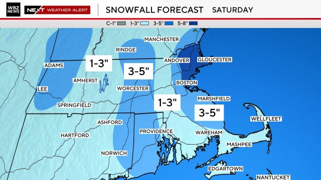
The batches of snow showers are very spotty and light so this will keep accumulations down. As the low tracks through tonight is should keep the heaviest snow across SVT, SNH and N. MA. Though snow will start off light, heavier bands may try to develop overnight into the early morning Saturday
SW flow aloft up the east coast is steering a significant plume of moisture up the East coast today but the rain is mostly moving offshore. Showers will come awfully close to Nantucket, but the rest of the region will remain dry and cloudy under a blanket of overcast which has moved in for the rest of the day. Highs will be in the Lwr 40's. A thinner overcast in the north and west where there will be some partial sunshine
Winds this morning are out of the SE. SW flow aloft is ejecting quite a moisture plume up the east coast keeping abundant cloud cover ahead of an approaching cold front. The heaviest precipitation has pushed offshore but lingering drizzle and fog in saturated airmass remains making for a very dismal day so far. Showers will try to redevelop moving from SW to NE right around midday as the front begins to push off the coast. Showers will linger into the early afternoon, then winds will shift to the SW behind the front. The drying and warming trend will develop this afternoon
New England has the best chance for accumulating snowfall. Along and north of the Pike will likely be in the best snow growth regions for substantial accumulations..track dependent. If everything comes together just right... some areas could see up to 6 inches of snow or more...but let's just rest on this for now. It has not exactly been a good winter for snow storms.
Sunday: Sunny, Breezy and Cooler. Highs in the 30's near 40. NW 15-30 mph Sunday Night: Mostly clear, calm winds and cold. Some clouds increase overnight. Lows in the lwr 20's
Well, you just do not get to see days like this very often do you? For weather lovers, the past 24 hours was about as good as it has been all winter

Here is a list of reports of wind damage around the region Saturday.
Winds will be strong and persistent enough to make for wind damage with fallen limbs, branches and power lines. Wind Advisory for most areas 20-30 mph winds gust to 50. A Wind warning along the south Coast including the Cape and Islands thru 8 PM for sustained winds 30-40 with gust to 60 mph possible.
Just a brilliant day across New England. Near 100% of the sunshine will be out there to enjoy. Cool winds from the NW is steering in a more seasonably cool airmass for the next 48 hours. Highs today range from 41 in SNH to 46 degrees at the south coast. High pressure to our west is directing the air right in from Canada...so despite our increasing day lenght and temps already in the 30's this morning...temps will be fighting an uphill battle to climb today.
Bright sunshine this morning with high pressure pulling off the Mid-Atlantic coast. Clouds will increase this afternoon ahead of an energized short wave which will push through tonight. Highs temps should be able to climb into the mid 40's ahead of the increasing PM clouds and west winds.

The New England Patriots are back in the Super Bowl once again in 2026, hoping to add another ring to their list of wins. Here's a look back at their appearances, losses, how many they've won, and more.

Not sure where to watch the 2026 Super Bowl live? There are multiple ways to watch the game for free today. Here's how.

It's a home away from home for Boston fans in San Francisco, and it's where many are stopping in ahead of the New England Patriots facing the Seattle Seahawks in Super Bowl LX on Sunday.

Bad Bunny is set to take the stage at halftime for the 2026 Super Bowl. Here's who else is performing at Super Bowl 60.

Plowable snow fell in Massachusetts on Saturday. Here's how much your area has gotten.
We've got yet another very cold and snowy weekend on tap in Boston. Here's what the weather forecast maps show.
Plowable snow is currently falling in Massachusetts. Here's how much your area has gotten.
It's a home away from home for Boston fans in San Francisco, and it's where many are stopping in ahead of the New England Patriots facing the Seattle Seahawks in Super Bowl LX on Sunday.
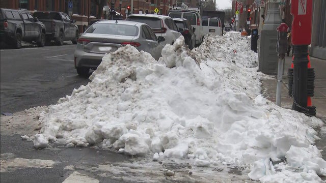
Boston Mayor Michelle Wu is defending the city's snow removal progress nearly two weeks after the storm hit.

Patriots fans will have the memories for a lifetime after traveling for Super Bowl LX.

There's a new drug that can help early morning shift workers stay awake and alert, a study out of Boston found.

As millions of Americans struggle with paying for health care, doctors and health experts discuss how medical care is being eroded by insurers denying necessary tests and treatment, making it "more difficult to be healthy in the United States."

Flu cases are rising rapidly, especially among kids in Boston, where hospitalizations of children under five have increased 150% over the last two weeks.

Four children have died from the flu in Massachusetts so far this season, public health officials say.

Fewer people in Massachusetts are getting their seasonal flu and COVID vaccinations as the number of respiratory infections in the state continues to rise.

After I-Team reports about a Foxboro woman's frustration with her GE gas range, the company has agreed to give her a refund.
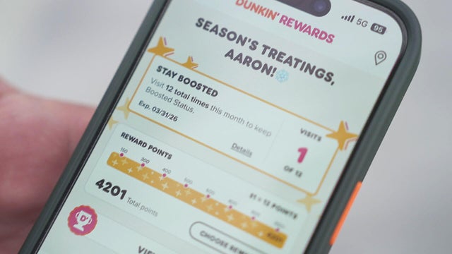
It took Aaron Braun years to get more than 93,000 Dunkin' rewards points, but after a policy change he's left with a fraction of that.

In the last three years, the Better Business Bureau has received thousands of complaints about GE.

A home baker from Foxboro, Massachusetts is frustrated that the pricy oven she bought from GE wasn't working properly. Attempts to fix it failed.

Eight states have laws making police body cameras mandatory. Massachusetts isn't one of them.

Both the Trump and Healey administrations are using government websites to blame each other for the shutdown.

Which party stands to take more of the blame from voters for the government shutdown? Here's what a new poll says.

A UNH Survey Center/Granite State poll shows John Sununu crushing Scott Brown by 23 points among likely primary voters in New Hampshire.

Seth Moulton said he's running against Sen. Ed Markey because "our party leaders are clinging to that old playbook."

Maine Governor Janet Mills' run for Senate comes with an unusual promise - she will only serve one six-year term.

Raising Cane's claims a Boston landlord has threatened to evict one of its locations in the Back Bay because the restaurant "smells like chicken fingers."
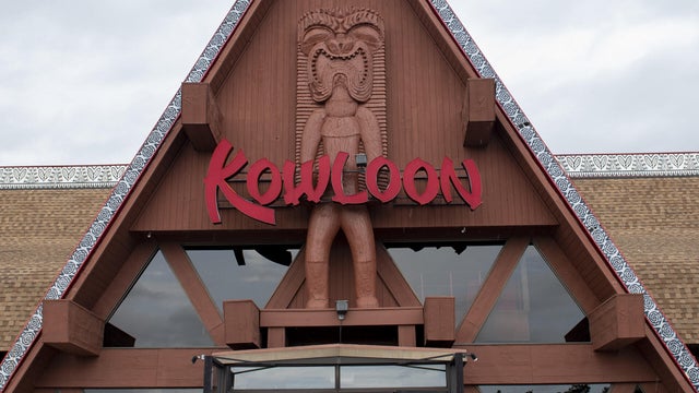
The Kowloon is coming to Revere Beach.
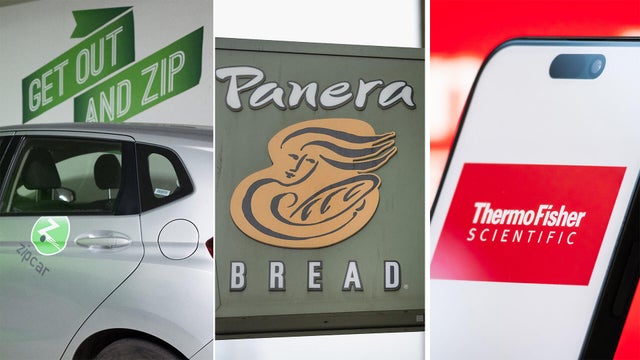
Panera, Zipcar and Thermo Fisher are all closing facilities or offices in Massachusetts.
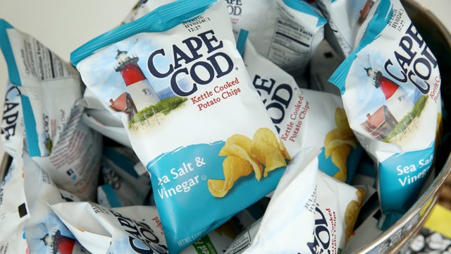
Cape Cod potato chips will no longer be made on Cape Cod as of this spring.

Time Out Market Boston, a food hall that opened in the Fenway neighborhood in 2019, won't be closing after all.

Just steps from the water's edge along Lake Winnipesaukee, a spectacular estate mixes modern architecture with breathtaking views.

An innovative craft winery located in downtown Meredith, New Hampshire, Hermit Woods is taking a different approach to winemaking.

Located on the water's edge along New Hampshire's Lake Winnipesaukee, Mill Falls blends elegant luxury with spectacular vistas.

Kohler Store by Supply New England and an interior designer showcases how beauty and functionality can breathe new life into a project.

James Beard-nominated pastry chef and co-founder of Bakey in Boston gives insight on how to make his world-famous babka.
The New England Patriots are back in the Super Bowl once again in 2026, hoping to add another ring to their list of wins. Here's a look back at their appearances, losses, how many they've won, and more.
Not sure where to watch the 2026 Super Bowl live? There are multiple ways to watch the game for free today. Here's how.
Bad Bunny is set to take the stage at halftime for the 2026 Super Bowl. Here's who else is performing at Super Bowl 60.
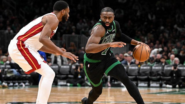
Jaylen Brown had 29 points and Payton Pritchard scored 24 points to help the Boston Celtics beat the Miami Heat 98-96 on Friday night.

Jayson Tatum is not ready to come back yet this season, Boston Celtics president Brad Stevens said Friday.
Raising Cane's claims a Boston landlord has threatened to evict one of its locations in the Back Bay because the restaurant "smells like chicken fingers."

A tegu lizard was found buried beneath the snow in Providence, Rhode Island.
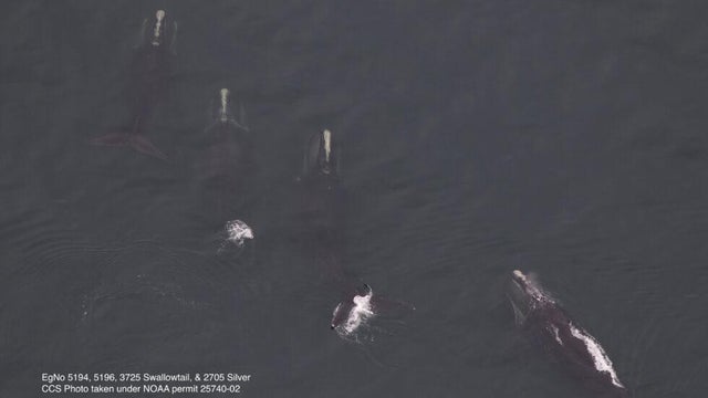
A gathering of North Atlantic right whales off Massachusetts over the weekend appears to have set a new monthly record.

A rocketship on a downtown Boston roof is part of the new Winteractive 2026 public art installation.

The overpowering scent of Dunkin' donuts in the air has some Haverhill residents complaining.