Winter Weather Returns Wednesday With Snow
BOSTON (CBS) - Only in New England can it be 60 degrees outside yet the main weather story this evening will be snow on the way.
So many people were outdoors Monday enjoying the last moments of our January thaw it was like we hatched out of our winter cocoons.
Check: Interactive Radar | Current Conditions | Weather Blogs
Were you one of those who emerged out of hibernation and said, "Geez, that winter wasn't so bad, this winter thing in New England is getting easy!"
Well don't be fooled, this winter is a very LONG way from being over. In fact, I believe the coldest and snowiest days are yet to come.
First things first. A cold front has made its way through New England (although you wouldn't know it based on the temperatures right now).
This front has opened the door for colder air to sneak in from Canada, and it will continue to leak in over the next few days. It is not going to be too dramatic. Highs Tuesday will actually still be slightly above normal, in the upper 30's to near 40.
The problem is that cold front is going to linger just to our south and become a weather boundary of sorts, separating the chilly air to the north and much milder air to the south.
This will become a breeding ground for ripples of low pressure (small storms) to form and zip by southern New England. The first of which will pass by tonight with just a few sprinkles or flurries expected well to the south.
A more significant wave will make a run at us late Tuesday night and Wednesday morning, bringing a steadier and heavier mix of precipitation to all of southern New England.
TIMELINE
It should commence shortly after midnight Tuesday as mainly rain along the immediate South Coast and light snow inland of I-95.
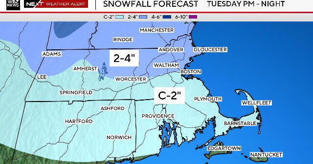
By the Wednesday morning commute there could be a dusting to as much as an inch of snow on the ground for much of Metro West, a rain-snow mix closer to Boston and mainly rain along the immediate coast and over southeast Massachusetts.
The rain-snow line remains a tough call at this time but we do expect the precipitation to remain all snow for areas north and west of I-495, perhaps as close as Route 128.
ACCUMULATION
Since the storm will be a relatively quick mover, ending Wednesday afternoon, the snow amounts should remain fairly low, 2 or 3 inches on average. There could be some spot 4 inch or 5 inch amounts in parts of Worcester County.
There will be very little wind with this storm and no coastal concerns.
After the storm departs on Wednesday, a series of Arctic fronts will come through over the next several days bringing waves of very cold air into New England.
The final push may come Sunday night, unleashing the coldest air of the season on us for next week.
You can follow Terry on Twitter at @TerryWBZ.
