Windswept Rainfall Tonight...Colder Air Returns...But For How Long?
Cool filtered sunshine this morning with increasing high altitude clouds will give way to mostly cloudy skies this afternoon and warming temperatures into the 40's. High pressure off the coast will wrap in warming SW winds...but the lack of sunshine will make it feel cooler. Keep a close eye on the radar today because we have quite a bit of rain just to our SW which is heading right to us for tonight. Clouds will thicken in advance of the rain this afternoon with showers arriving in western New England around sunset. Showers will be reaching the coast between 6-8 PM...
The main event comes after 8 PM. This will be a fast moving windswept rainstorm which will last about 6 hours. The peak of the rain will be from 8 PM-2AM. The rain will quickly be tapering off after that time. The low is currently in the Tennessee Valley. It will track to eastern PA by 6 PM, then up the CT valley tonight where it will deepen and be pushing into Canada by dawn tomorrow. We can expect a widespread .5-1" rainfall out of this...with a few embedded t-storms possible later tonight. The progressive nature of this storm will keep flooding problems minimal. Unfortunately this is a warm storm...even our northern mountains will get rain out of this...but it should not be enough to wipe out the snow. The rain will simply be absorbed.
The National Weather Service has issued a High Wind Warning for the Cape & Islands and a Wind advisory for the rest of the coastline of New England. This storm will be accompanied by a strong low level jet on it's eastern side. At 925 mb winds will be howling at 70-80 kts just above our heads. Any downpours or T'storms may be able to mix this winds down to the ground. Peak winds are expected between 9 PM and 3 AM. Winds may gust from the south to 50-60 mph on the Cape & Islands as this storm blows through. This may produce some scattered tree and limb damage.
Temps will rise into the 50's on this southerly wind during the evening hours. Mild air will be in place left over from the storm for the morning hours. Once this storm departs, strong winds from the NW on the back side of with building high pressure will direct another cold shot of air into the northeast. Temps in the 40's tomorrow will be falling into the 30's by afternoon with winds still gusting to 40 mph Wednesday..thanks to the cooler blustery NW wind direction. Cold air in place of Wednesday Night into Thursday.
Lo0king ahead to Friday, a weak clipper low will push through New England providing a light mix of snow showers across the north and light rain showers or sprinkles in the south. Once this low passes through...the confidence in the long range looking to the New Year goes down the drain. Timing what happens after Friday is still up in the air as our models have shown a variety of solutions for what will occur this weekend. The Euro has another low following right behind the Friday low...for another shot of light Snow Saturday in southern new England....While the GFS and Canadian have weak high pressure Saturday with another clipper low pushing into Northern New England Sunday with another wintry mix. So we will see how this all plays out. Which camp eventually joins with the other? Until then...I am remaining optimistic for a dry First Night somehow between these disturbances...but that could change as well.
There is still hope for a pattern change into January...A turn to colder and snowier times is likely...
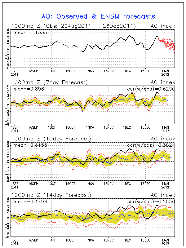
This year so far the North Atlantic Oscillation and Arctic Oscillation have remained positive. This has prevented any upper level blocking pattern so far. Last year at this time, both of these indicators were negative and we were just beginning to enter a 6 week period of extreme winter weather none of us will soon forget.
Looking at the AO chart below, which is similar to the NAO too...there is a trending down towards the neutral and maybe even slightly negative heading into January. It is nothing to get excited about...but it is something that will help the cold to build in the Northern Hemisphere, a few more stronger troughs to develop, and maybe just maybe some upper level blocking ...maybe by the end of January.

The GFS ensemble out to January 5th shows a trough in the eastern half of the country, but this is simply a cold shot of air following in behind what ever moves through this weekend. I would not be surprised to see something come together off the coast when you see how deep the trough extends down into the Southeast
Again, just showing the colder start to next week , a deep trough, temps below normal. Can it hold?
Looking out to the 11th, a broadscale trough and a serious push of cold air. So a colder look and feel can be expected for January which may be more persistent through the end of the month...but I cannot guarantee the blocking pattern until NAO & AO start looking more negative.


