Widespread 8-To-12 Inches Of Snow Coming In Weekend Storm
If you have been following along you may remember many days ago when it was just a baby, a piece of energy sitting off the Alaskan coast and we said that so much could happen on its journey across the Pacific and then the United States. Well, our baby is growing up and taking shape.
 BOSTON (CBS) - There is no avoiding it now - snow is coming - our biggest storm of this young winter season is on the way.
Check: Current Conditions | Interactive Radar | WBZ Weather Blog
Currently it is "maturing" over parts of Oklahoma and Missouri and in the next 24 hours it will bring snow to places like Chicago, Indianapolis, Cleveland and Pittsburgh.
But, unlike its predecessors this season, this storm is going to save its best for last. We will be the lucky (or unlucky, depending on how you look at it) recipients of the brunt of this storm here in New England. It may not be coming during a weekday commute, but given the time of year, its impact will likely be just as important with all the various holiday plans and travel expected this weekend.
So let's take you step by step:
Noon Saturday-to-5 p.m:
Light snow will begin to break out here and there but should not have any real impact on the roads. It will not be snowing everywhere during this time and where it does snow it will just act like a little background holiday music, perhaps help to get you in the spirit. Nothing more than a scattered dusting.
5 p.m.-to-11 p.m:
The snow becomes a bit more organized and by the end of this time frame it should be snowing light to moderate everywhere. By 11 p.m. we expect there to be 1-to-3 inches of snow on the ground and the roads will begin to deteriorate. If you have shopping plans or plan to travel Saturday, I would advise getting things done and getting home before 11 p.m.
11 p.m. Saturday- 8 a.m. Sunday:
The "brunt" or peak of the storm. This is when 80-percent of the accumulation or more will happen. The latest weather model indications are that snow will come down pretty heavy during this time period, perhaps at about an inch per hour at times.
Winds will pick up out of the East Northeast, especially along the coastline, gusts will be 20-to-40 mph. Driving conditions will quickly become poor and visibility will be low.
So, if you do the math, if we manage to snow at an inch per hour for 6-to-8 hours, then you get about 6-to-8 inches in this time period alone. The rain-snow line will also creep northward during these hours, getting as far north as the Boston area by 7 a.m. This will hold down snow accumulations in southeastern Massachusetts and along the coastline.
After 8 a.m. Sunday:
The storm quickly moves east and out to sea, with very little, if any, additional accumulation in southern New England. Snow will have changed to sleet or rain from Boston points south and the snow will lighten up to the north and west, completely shutting off by noon.
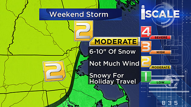
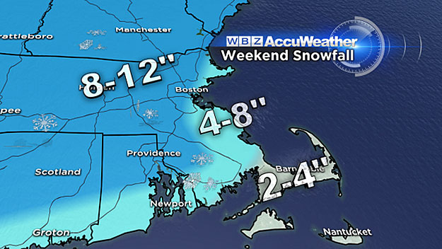
So you add it all up and you get a widespread area of 8-to-12 inches of snow from just about Boston to all points north and west.
There could be some spot totals as high as 13-or-14 inches in the elevated terrain of Worcester County, or anywhere for that matter, if we get a heavy band to set up shop for a few hours during the peak of the storm overnight.
South of Boston, over most of southeastern Massachusetts, there will be 4-to-8 inches of snow and then a changeover to sleet and rain, making more of a heavy, wet slop by morning. Only 2-to-4 inches of snow are expected on Cape Cod, most of it will turn to slush by the change to rain fairly early on.
Follow Terry on Twitter @TerryWBZ
MORE LOCAL NEWS FROM CBS BOSTON
