As Dylan once said, The times they are a changin''. Balmy breezes will change to brisk chilly winds by the time we finally change from warm to cool. I like to save the word COLD for when we really mean it. As we move to different airmasses, we have some unsettled weather to go through . A slow moving cold front is pushing into New England today. We are warming ahead of the front with breezy SW winds. Temps started off in the 50's and will be climbing into the Lwr 60's today. Periodic light rain and drizzle on and off through the day...most of the precip is light, and there will be times where it is not raining at all. Showers may try to fill back in later today only to taper to drizzle tonight, only to redevelop again tomorrow. We will track weak waves of low pressure on a front which will stall south of us tomorrow with cooler NNE winds temps will mostly be in the 40's near 50...with the lingering rain and drizzle.
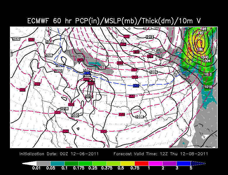
Of more interest and importance is the final wave of low pressure coming out of the Carolinas later tomorrow and up the coast of New Jersey, and then tracking near Nantucket, and into the Gulf of Maine by Thursday morning. As we mentioned yesterday about the storm potential, most of the models are now coming together with this storm. This has some moisture to work with(.25-1") and warmth as it arrives Wednesday night. Precipitation will start as rain through midnight. But as the low deepens, it will start to drag in colder air from the north and rain will begin to change over to snow after midnight. The Euro has this low deepening to 988 mb by Thursday 7 AM.

The NAm is a bit weaker and a track slightly farther east over Nantucket. Either way, this will be a quick moving storm with it's worst impacts occurring while most of us are asleep. This storm will be quickly pulling away by mid morning on Thursday...but some of us may be left with a sloppy and slippery morning commute, especially once out of 495. Below is a map showing an idea of what it will look like after midnight with rain changing to snow. Notice the heavier bands in the NW, hitting the same areas which hit the hardest in the late October Nor'easter
These storms lean towards the cold. The heaviest snow tends to occur about 60-100 miles to the NW of the 850 low where temps are -5 to -10 at 850 mb. This is an area where the snow can form the best because of the cold dry air. Looking at the NAM map below...It looks like the Berkshires, SW NH, and Worcester Hills have the best chance of seeing a plowable snowfall of 2-6" with the higher numbers for the higher elevations. Once inside 495 to the coast, the warm air will hold on the longest in the overnight hours. There will be a brief change over before the storm pulls away. There just will not be enough time to snow very hard so this will keep accumulations down across Metrowest to SE NH...1-2" at most..... The south shore to the Cape & SE MA will likely not see any snow accumulation from this.
Brisk NW winds will follow behind the departing Thursday afternoon and provide a significant chill to the air with highs in the mid 40's...but feeling colder. Friday will be a mix of sun and high clouds. An Arctic front will approach late Friday and push off the coast early Saturday. Th first real shot of cold Arctic air will be in place Saturday with highs only in the 30's to near 40. Building high pressure through the weekend will provide increasing sunshine as well as moderating temps back to near 50 by Monday.
This cold shot will be short lived..but as we have talked about...this December is going to have an overall cooler feel, more frequent cold shots, less mild air because of a more active Polar jet, with the potential for Clippers. But there will still be a fairly flat flow to the overall jetstream. Arctic Air should hold most of the time in Canada through the 19th. Not a very cold or stormy look...just cooler.
