Tracking Hurricane Joaquin: An East Coast Hit?
BOSTON (CBS) - When digging into a forecast, you're always going to have knows and unknowns.
The biggest misnomer when it comes to weather is that it's bad to have uncertainty. A real forecaster would just tell you what's going to happen, end of story! But the truth is that uncertainty is a very real and constant feature of trying to predict the future. This isn't a knock on the state of forecasting - the practice of figuring out what trillions upon trillions of air molecules are going to do days in advance. It's just a part of the science, and in turn needs to be a part of the forecast that's handed off to the public. Making a point to highlight how confident a forecast is allows people to plan appropriately. For example - do I start sandbagging right now, or wait a day? Do I rearrange all my flights or is it best to hold out a little longer? Is this storm set in stone, or could it change it's track?
Over the next several days, we have plenty of knowns and unknowns.
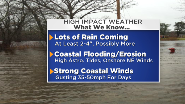
We know it's going to rain quite a bit through Friday. We are confident in the rain totals expected. We're confident temperatures will drop by Wednesday evening, and that winds will pick up out of the northeast. We're expecting that those gusty winds at the coast will build surf, pile up water, and lead to pockets of coastal flooding. These are all things you can take to the bank.
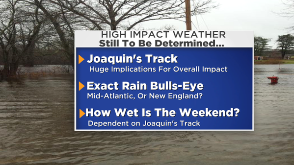
But the biggest question mark ahead of us also brings with it the highest potential impact - Hurricane Joaquin.
A widespread 3-to-5 inches of rain (perhaps some locally higher totals) Tuesday night through Friday is doable.
We'll have pockets of flooding in urban areas, and some small streams could see significant rises. But more likely than not - it's a much needed soaking that will dent the drought and brings waterways back to where they should be.
But when you throw in the potential of more tropical rain with Joaquin - we could move into the 'too much of a good thing' category. Plus there's always wind involved when a tropical system approaches, so there's lots to be wary of in the longer-range portion of the forecast.
I can't stress this enough - New Englanders should be very vigilant over these next several days.
The eventual track of Joaquin has been a focus of frustration for meteorologists so far. Highly sheared storms are rarely captured well by models, and their long-term forecasts suffer.
To date, the system has been lopsided and disorganized, although it is certainly now starting to show signs of strengthening. All told, it's battling 20+ knots of shear pretty well.
You may have caught some of those 'spaghetti plot' images showing its future path splayed out in all directions - from out to sea to crashing due west. In short - it's been tough projecting the road ahead.
A great link for what all those 'spaghetti model' tracks mean here: Interpreting tropical spaghetti
Looking for a little clarity, I stopped looking at all these model tracks and just focused on the overall synoptic (large scale) setup.
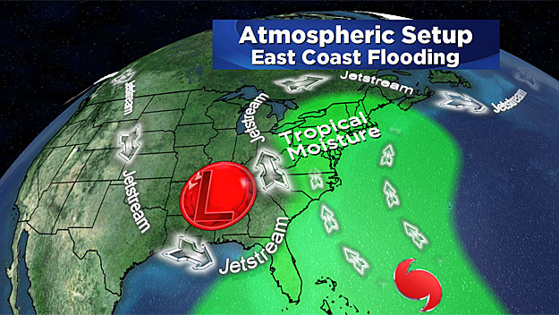
When you take a step back and do this, you notice that even though models are all seeing different paths, they're all quite similar in the main players involved. A trough digging into the southeast with a potent upper-level low tilting slightly negative. A blocking high east of New England out over the Atlantic. A feed of tropical moisture rising northward on deep-layer southerly winds. And maybe even Ida coming back from the dead in the middle of the Atlantic and joining the party by Sunday night/Monday!
It's a lot to keep track of, but the message seems pretty consistent. It's a setup where heavy rain is unavoidable in the East.
All told, this also looks like a pattern that will make it tough for Joaquin to escape. It seems like a classic highway to draw the storm in, lift it up the coastline, and funnel it either into the Mid-Atlantic or New England.
As of this writing, an out-to-sea scenario seems less and less likely to me. While some models have jogged Joaquin well to the east, even as far as Bermuda, the steering currents to make this happen are difficult to discern. I'm just not seeing the potential of this to escape the digging trough and deep layer southerly flow. Plus, blocking high pressure to the east should help cage the storm in.
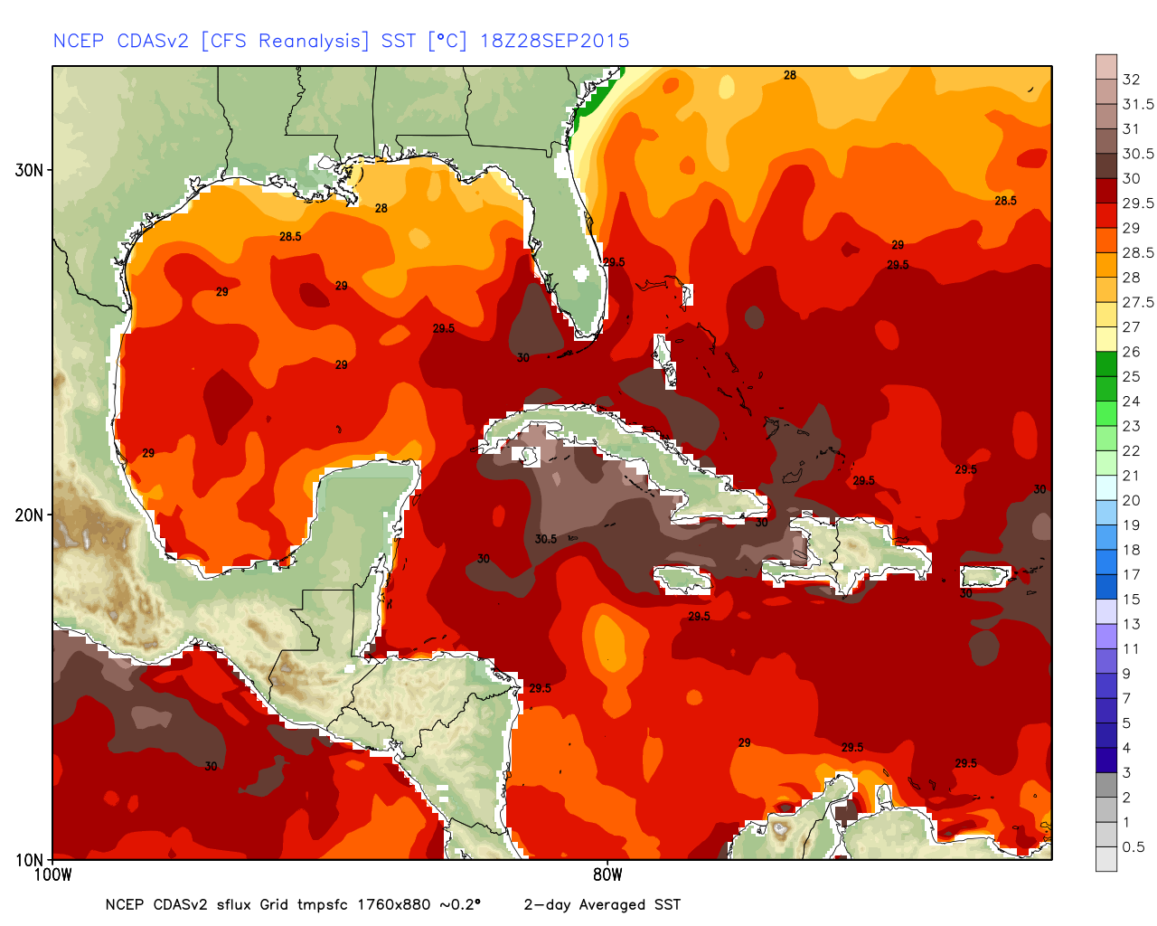
On top of this, conditions become more favorable for development Wednesday and Thursday. The storm will get into an area of lighter shear, and water temperatures are still plenty warm this time of year. SSTs are running well above average, and Joaquin will be heading over an area of water 29-30ºC for the next several days. The warm water is also deep, providing significant heat content. After that, its forecast track keeps it close to the Gulf Stream. So energy in the form of heat is not a lacking - in fact it's higher than usual for early October. It's not out of the question that the storm could quickly jump to a Category 2 hurricane, and in a 'worst case' scenario even get to 'Major' Cat 3 status.
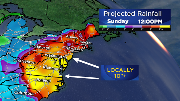
Bottom line of all the technical talk is that everyone from North Carolina to New England should pay extremely close attention to Joaquin. There will be flooding regardless, but a near pass or landfall could allow areas to blast into the double digits for rainfall with ease. I'm not seeing a situation where *someone* on the East Coast doesn't get soaked in flood waters. The pattern almost guarantees it. The trick is figuring out where. And in the meantime make sure your sump pumps are in working order!
If we're placing bets here - I think a landfall is in play between the Outer Banks and Long Island. That's a big area for now, but the idea is to raise the alarm that people should be vigilant and proactive in their preparations, so as to not wait until it's too late to get ready.
Hurricane hunters are adding dropsondes and more of the environment is being sampled right now. The next 24 hours will be telling, and hopefully a much more exact track forecast will be possible by Wednesday night or Thursday. Any landfall or close pass would not likely happen until Sunday, so there is still time to get ready if all these factors come together.
In New England, the storm would not arrive until late Sunday or early next week. So there's time to monitor and deal with the issues we know are coming well ahead of Joaquin (mentioned above). As talked about during previous blog posts and forecasts, the 'best case' is about 3-5" of rain. The worst case is Joaquin coming up the coast and bringing our totals Tuesday PM - Monday into the 6-12" range.
We'll keep you updated all along the way!
