Tracking A Pre-Season Nor'easter
This is a storm which may catch some by surprise. It is going to come with strong winds at the coast, battering waves at the beaches, rain and wet snow for the Monday morning commute...It's effects will be slow to leave.
This is not a major Nor'easter by any means and will be more of an annoyance than anything...but this will come with a punch..especially at the coast ..and even deliver our first snowfall of the season in some spots..No need to panic. Just a little warm up for the long season ahead!
Clouds are rolling in and thickening despite a few break of early morning sunshine in the interior. A steady flow of clouds and moisture is being directed up the east coast thanks to a deep trough in place on the eastern seaboard. Energy digging into the trough will allow low pressure to deepen off our coast and back into New England late tonight-tomorrow. As this low begins to deepen winds will be increasing at the coast this afternoon where we could see gusts over 30 mph.
Showers are possible along the coast tonight...mainly late tonight after midnight. Steady onshore winds will provide a moist feed into the region with the best lift in the atmosphere occurring through tomorrow morning.
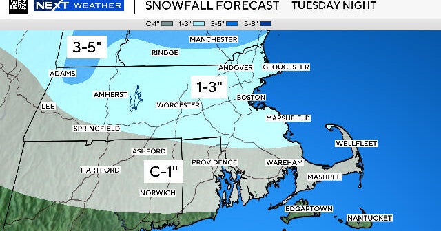
Temps will be cooling overnight with the freezing level dropping down to 500 feet by dawn in SW NH and the Worcester hills and NE Connecticut. Expect a rain/wet snow mix just in time for the morning commute tomorrow. A slushy inch is possible in the hills of Worcester County...but wet flakes/sleet could even mix in Monday morning in Metrowest and Boston. This will be short lived as the column will begin to warm with the rising sun.
Here are the average first measurable snow dates for a few cities. The season's first measurable snow usually holds off until around Thanksgiving in Boston, Hartford, and Providence on average...but it certainly can snow earlier than this!
| Boston | November 28th |
| Hartford | November 23rd |
| Providence | November 28th |
| Worcester | November 16th |
Monday will be a raw cool windy day with rain of varying intensity. A general .50-1" of rain is likely with a few heavier spots possible. Strong winds will be mostly confined to the coastlines where winds out of the northeast will gust between 35 -50 mph Late-tonight into Monday. Winds will diminish with the low moving over the Cape..only to pick up again Tuesday & Wednesday out of the northeast as the low slowly pulls away.
Rough surf with seas 8-12 feet will persist through Wednesday. High astronomical tides is combination with persistant onshore winds means there will several high tide cycles where exposed eastern facing beaches will see beach erosion and minor coastal flooding from Portland to Nantucket.
The surface low will eventually become vertically stacked with the upper low and begin to weaken Tuesday. Plenty of lingering light rain and drizzle into Tuesday. The upper low is not going to move fast...in fact it will remain close enough to our coast to keep the Northeast winds going through the rest of the week...despite increasing sunshine and a return to seasonal temperatures. The warmth in the midwest will remain there as long as we have this trough nearby..
Something we will have to watch is Tropical Storm Tomas down in the Carribean. Some of our models show the energy from this storm becoming entrained into the trough. The energy would be directed up into Nova Scotia then into the upper low to help to strengthen this storm by the midweek...Anytime a tropical system merges with a cold low...it makes you think of the Perfect Storm. Our models are not the best at picking up the transfer of heat and energy. This could get interesting and certainly bares watching! Still leaning to a sunny end to the week.


