Spring Has Sprung!
Now that we have sprung our clocks forward...now it is time Spring up our temperatures...Just like clockwork. Even though the Vernal Equinox happens on March 20th...A very Spring like weather pattern is setting up which will set into high gear our spring fever. The warmer weather will bring on the crocus and daffodils. Trees will start budding and put an early end to the maple sugar season. Pollen season will start to come on strong thanks to the dry and warm winter. It all begins today.
High pressure in place across the mid Atlantic is pulling offshore and will begin to wrap in a breezy SW wind today and start the warm up with highs climbing into the 50's. Awesome spring skiing today...but maybe too bright at times. Sunglasses and sunscreen will help your enjoyment today. Today will feature near 100% percent of the sunshine. With the dry breezy conditions and lowering relative humidity the National Weather Service says there is an enhanced risk for brush fires today. Clear skies tonight will allow for an amazing view of Venus and Jupiter in the western sky after sunset. They will appear very close together like two diamonds in the sky. Venus will be the bigger of the two. Also, thanks to recent solar flares off the Sun, there is the potential for Aurora sightings...in the far north, away from city lights. The Northern Lights are so elusive and hard to see, I don't like to bring it up...but if you are in ski country...it might be worth a try late tonight.
Most of New England woke up this morning with temps below freezing. Could this be the last time of the winter? It is quite possible we will not be this cold again until next winter. Hard to be 100% on that, but obviously we are all pretty confident of a spring warming trend which will last at least for the next two weeks. After that winter, just runs out of time as we quickly head into April. Lows tonight under the clear moonlit skies will hold in the 30's above freezing.
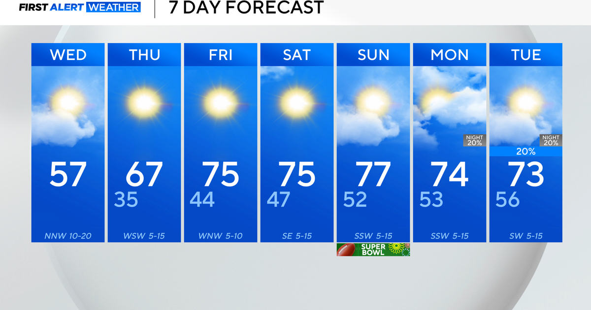
Monday will be sunny and very warm for this time of year with temps close to 20-25 degrees above normal. SW winds will pump our highs into the 60's to near 70 with warmer air from aloft mixing down to the surface. High clouds will be increasing later in the day ahead of a warm front
The low will track into the Great Lakes with a weakening front as it runs into the upper level ridge on the east coast. This will mean clouds Monday Night into Tuesday AM with a few spotty showers. The warm front will lift north Tuesday with breaking sunshine and warming temps again into the 60's with SW winds at the surface. A cold front pushes through late which may trigger another shower late in the day or at night.
Temps will briefly dip into the 50's to near 60 behind this front Wednesday with a mix of sun and diurnal cloudiness thanks to cooler air aloft. But the upper level ridge will quickly re-establish itself through the middle to end of the week with more sunshine and warming temps for Thursday...Lwr-mid 60's and back to near 70 on Friday.
Again, Friday another cold front will approach. Warming SW winds ahead of the front all day with the risk of a few hit or miss scattered showers. A wave develops on this front which becomes stalled over SNE...and could make for a wet Saturday with cooler temps back into the 50's and cooler sea breezes into Sunday
The ridge will gain control on the east coast will again control once gain by Monday the 19th. Temps should surge into the 70's by that time through Tuesday. Any warm up this time of year can quickly be cut short by backdoor fronts or easterly winds off the cooler ocean water. That is something we will have to watch for along with passing weak fronts with slightly cooler air behind. The outlook for the next 8-14 days from the Climate Prediction Center still has a very warm signal through the 24 th and I have no reason to doubt it.
Again, it will not be a perfect warm up...a few bumps in the road along the way....but Spring has Sprung! Even though it may be a week early on the Calendar, it is good to know winter is over. It never really arrived anyhow.

