Soon to be Rewarded...
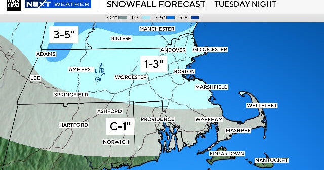
We are now going on week three of talking about this upper level storm system and it's associated unsettled weather...the end can't come soon enough! Another wave of rain is overspreading us right now and we will see periods of rain as the entire system rotates over us tonight and tomorrow. Up until this point, we have been on the warmer side of the system but by tomorrow that changes as the winds swing around into the NW so expect chilly raindrops.
On Wednesday, the surface low will be pulling away and so will the upper level low but we will still be on their periphery and cyclonic flow will mean only partial clearing or more clouds than sun. There is also the risk of a brief passing shower...these represent the leading edge of the coldest air of the season.
With high pressure building in for the end of the week we will literally see wall to wall sunshine but the air will be dry and cold. 850mb temps will be around 0C so daytime highs will not clear 60 and the mornings with ideal radiational cooling conditions on Friday morning, temps could get down to the freezing mark for the first time this season in Boston's suburbs.
The Autumn feel will quickly retreat over the weekend as the high slides south of us and the airmass begins to warm. Another taste of Summer is in the offing over Columbus Day weekend with record warmth very possible next Sunday when highs should eclipse 80!