Some Quick Thoughts...
Latest information today for the Christmas eve-Christmas morning snow looks a bit weaker than the morning runs.
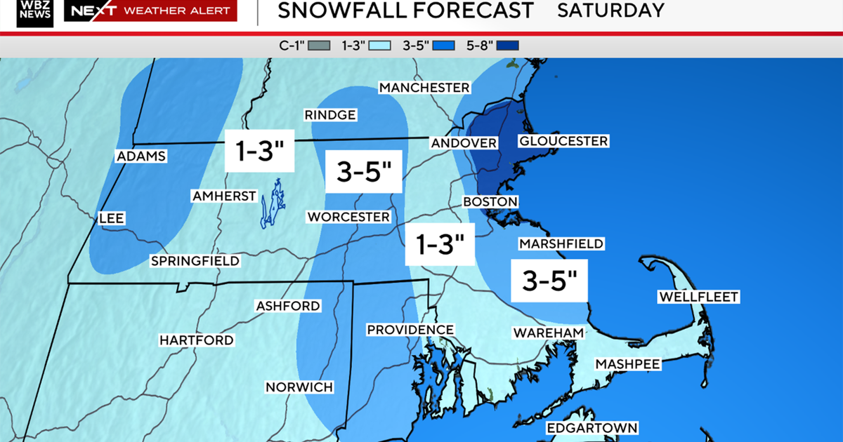
Light snow should begin around 8 p.m., with a steady light snow for Christmas morning.
CHECK: Current Conditions | Interactive Radar | Watches & Warnings | WBZ Weather Blogs
One low will head up through the Ohio valley then transfer its energy to a weak low sitting over Cape Cod at dawn Christmas day.
It will be a flat progressive shield of light snow mainly, so accumulations should be light..in the order of 1-3". There may be a few pockets of 4" if any banding develops, with the best chance of this happening in the Worcester hills, Western MA of N. CT. Best chance of heavier snow will be closer to the colder air away from the warming influence of the water. It will be more of a wet mix with rain for the Southeast MA & the Cape. Maybe a 1" toward Plymouth, with no accumulation for the Cape.
This should make for a nice beautiful morning for everyone. Luckily, it will be light enough to spare any big problems. As always, it is still early and we will be fine tuning this forecast as we get closer.
Wave #2 will be right on the coat tails of the Christmas snow. It will be coming out of the Gulf with more moisture and taking a track similar to wave #1.
This storm will have more energy and moisture to work with so it will be a more significant storm. The jury is still out on how this storm will eventually play out. The latest info on this storm came in warmer this afternoon, compared to the colder look of this morning. No sweat. We will see multiple changes of track before its arrival as the model tries to figure out how to handle the energy and set up. Just like wave #1, we will be seeing energy being transferred to the coast which could allow for a stronger secondary low to develop. The models today are not seeing that so they have a warmer scenario. This is something we will have to watch for trends. Also, the lack of a strong high to our north for a good inflow of cold air into the storm is a bit concerning.
So there are plenty of questions with this Nor'easter which we will keep looking into. But this is what I do know based on what we see today...The precipitation will start late Wednesday afternoon. Starting off as a snow, before transitioning to rain in parts of SNE..especially across eastern MA as strong east winds should allow for some warmer air to come in off the water.
A few models like the GFS and Euro look warm with a low tracking over us...but there are colder models like the JMA and Canadian, UKMet which have a colder storm tracking south of New England and really becoming a powerful winter storm.
So we need to see a little more agreement before we really know which way this is going to go.
Where it remains all snow...6-12" of snow will fall easily. Snow/rain line concerns exist at the moment so where the heaviest snow happens is still remains to be seen.
Today it looks like Northern & Western New England but this could shift farther south with a more southerly track.
All track dependent at this point. Any rainy mix should change over to snow as the system departs on Thursday afternoon. I expect this storm to trend colder. If it does...look out!
Strong gusty winds will be fond on the frontside of this low from the east on the back side with cool NW winds. A significant storm which is still a bit of a mystery. Barry Burbank will be in Sunday morning to give his best estimation. Stay tuned!


