Snow on Tuesday Does Not Look Impressive.
Cold Blustery winds will dominate on Sunday. A shortwave is diving SE from the Great Lakes and will help to steer mid level clouds into the region this afternoon, sun fading behind increasing PM clouds. Highs will remain in the 30's near 40. Wind Chills in the mid-20 to mid 30's. Clouds will break and clear overnight with diminishing wind and lows again dropping into the 20's. Monday will feature clear skies, less wind a slight moderation to the airmass with highs in the mid 40's
Check: Interactive Radar | Current Conditions | Weather Blogs
Most of our time and energy has been on the piece of energy currently sitting over Montana. This shortwave will be digging into the midwest with a developing low at the surface coming out of Louisiana and Arkansas.. As this pice of energy swings into the Ohio valley, it will help to direct this developing low off the coast to North Carolina and the Virginia capes as weak wave which will ride well south of the bench mark. This track will help to prevent any heavy snow accumulation in SNE this time around. There is now plenty of model consensus. As we know, plenty can change between now and Tuesday, but this time around, it appears we will be left feeling a little "flat".
Temperatures will be cold enough to support a mainly snow event but the question is just how much moisture will be in play. Recent runs of the GFS, NAM, Canadian show a glancing graze form the northern fringe that develops too far away to have any real impact except for a brief period of light snow or flurries in SNE Tuesday Afternoon. A huge change from the GFS yesterday which had a much stronger storm and a walloping for the NW mountains. This shift to the south shows it is hopping on to the idea what the Euro had all along.
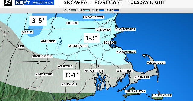
Yet, oddly enough, now the Euro is one of the stronger of the bunch with this wave and has one of the closer tracks to New England, despite the fact it will still be too far away. With slightly more cyclogenesis, the Euro provides the potential at least for a small accumulation of snow (1-3") for southern coastal CT, RI & MA...if they are lucky. The most robust model with snow would have to be the RPM. With a more widespread 1-3" across most of eastern MA, with pockets of 4" in eastern CT and RI. Less accums right at the coast with the potential for more mixing...especially for the mid-outer Cape which should remain mainly rain.
So we will continue to watch this weak wave for any more further development, but right now it just dot seem to be coming together in time with not enough blocking in place in a fairly flat progressive flow. Still, a few inches can have an impact especially if it happens during a commute. The timing would be Tuesday afternoon and Tuesday night. The best chance of accumulation will be in CT, RI and SE MA for now. A bit of a downer for snow enthusiasts who are eagerly waiting in anticipation. Still, I want to keep the door open for any future changes in track which could happen.
Since the storm will not be as strong, not as much cold air will be brought down behind it. Still a colder airmass will be steered into the Northeast with breezy NW winds behind this wave where highs will remain in the 30's with sunshine. The colder air will begin to lift out during the weekend. An upper level ridge will become established on the east coast for the first few days of December which should keep temps warming back up into the 50's by December 3rd or 4th.


