Wet Snow Flakes Possible For Parts Of Massachusetts Friday
BOSTON (CBS) - It was only a matter of time before the feared (and often times celebrated) "S" word returned to our forecast. This Friday seems to be the first case for snow this season in Massachusetts.
Oddly enough, this week's snow chance is a result of a tropical system. Tropical Storm Zeta, the 27th named storm of the 2020 Atlantic Hurricane season, is expected to reach Category 1 strength by Monday evening. It's track once again moves towards the north Gulf and Louisiana coastline. Landfall seems imminent towards New Orleans by Wednesday and then the energy trends north and east over a 48-hour period.
By Thursday evening, the tropical moisture will reach southern New England and it's expected to bring drenching rain.
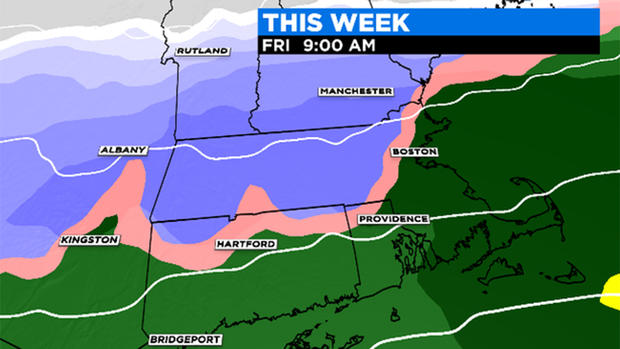
Steady showers will continue overnight. As a large area of high pressure slides south of Hudson Bay, the cold pool from the north will interact with the steady showers flipping the rain to wet flakes on Friday morning. The best case to see the snow will be prior and near sunrise.
As of now, there is a clear divide between the snow in central and western parts of Massachusetts and the rain for coastal areas. There is still some variation but this event is likely dependent on elevation so the Worcester Hills and Berkshires have the best chance to see any dusting/light accumulation. The October sun angle will likely force any wet flakes to return to rain by mid-morning Friday and shouldn't leave anything behind.
The map below indicates the areas that will likely report the snow, however it shouldn't be amounting to the inches it's forecasting. Lower values will be measured with this first snow.
Plenty more to come as we track these flakes! Stay with the WBZ-TV weather team all week for updates.
MORE FROM CBS BOSTON:
• America Can Probably Now Understand Why Tom Brady Left Patriots
