Snow For Southern New England Coming Late Thursday
BOSTON (CBS) - Mother Nature is giving it her best shot this week, trying to accumulate some snow and make our landscape look more like winter, but it is not coming easy.
Check: Current Conditions | Weather Map Center | Interactive Radar
The jet stream has suddenly become very active and several fast moving storm systems will be passing through New England in the coming days.
So are we finally turning the corner into real winter?
Well, not necessarily.
Storm #1 is coming right out of Canada, what we typically call an "Alberta Clipper."
These systems are typically fast moving and starved for moisture and this one will be no different.
The one thing we will have in place for this storm unlike just about any other this season will be cold air!
No rain or mix this time, it will be all snow for our entire area.
TIMEFRAME:
Snow will begin just after the evening commute Thursday night and continue light-to-moderate for about 6-8 hours, ending before the morning commute on Friday.
ACCUMULATION:
There will be a fairly widespread 1-2 inches in all of southern New England. The highest amounts will be found in the slightly colder air and higher elevations in central and western Massachusetts and southern New Hampshire, where there could be a few isolated 3 inch totals. Closer to Boston and along the South Shore, slightly lower snow totals are likely, about an inch or so.
A second storm will be right on the heels of this one.
Storm #2 will come from the Pacific Northwest, link up with some energy and moisture out of the Gulf of Mexico and therefore have a bigger potential than Storm #1.
TIMEFRAME:
Precipitation should start Saturday morning, mainly as snow. There will likely be some mixing with sleet and rain close to the Coast and in southeast Massachusetts during the day on Saturday. The storm will move quickly and taper off Saturday evening.
ACCUMULATION:
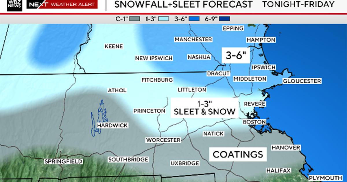
Obviously where it stays all snow, we will see the highest amounts and that is likely to be in northern Massachusetts and southern New Hampshire.
Areas north of the Pike and especially north and west of 495 will have the best chance to see the greatest snow amounts. In these locations there could be as much as 3-6 inches of snow.
In Boston and nearby suburbs, assuming there is a mix, snow amounts could be closer to 1-3 inches.
We should stress that it is still early and weather models have not yet come into full agreement on the track of this storm, so there will likely need to be a shift in amounts as we get closer to Saturday.
Watch Melissa Mack's forecast:
Looking ahead to Sunday, the weather in Foxboro for the Patriots game should be fairly decent by January standards.
Temperatures in the mid to upper 30s for kickoff at 3 p.m. under partly to mostly cloudy skies with just a chance of some light drizzle or a few flakes, but nothing significant.
You can follow Terry on Twitter at @TerryWBZ.