Snow & Bitter Cold Temperatures Moving In
We are currently in the midst of a 2-day warming trend. The sun will be shining and temperatures wil return to the middle 40s today. Tomorrow will be another sun-filled day with highs flirting with 50F! Clouds will begin to blanket the sky on Friday evening.
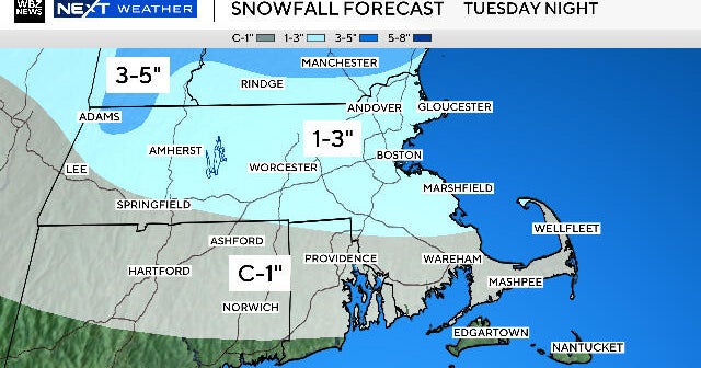
Saturday's snow: Models are coming closer to an agreement. This morning, all of the models show at least some snow in the forecast. The focal point appears to be Plymouth and Bristol counties along with the Cape/Islands. This is where models are showing the highest QPF values with their current track(s). The NAM is showing a more robust outlook, which is closest to the EURO solution. Take a look...

This COULD mean a 3-6" of snow for Plymouth/Bristol counties down to the South Coast/Inner Cape/Islands. The same models are showing 2-4" from Lawrence to Boston to Worcester. And a coating-2" for points located farther north and west.
That being said, the GFSx is still the outlier showing much less QPF and depicting the surface low on a more offshore track. The GFSx shows a maximum snowfall amount of 2-4" for the the same focal points...Plymouth/Bristol counties along with the Cape/Islands. The GFSx shows a coating to and inch elsewhere. Here's a look at the latest run...

As our WBZ Weather Team has been monitoring this storm potential, the EURO has been the most consistent followed by the NAM. So, that leads me to believe that those solutions have the highest likelihood of coming to fruition. I am preparing for at least a few inches for Lawrence to Boston to Worcester and cities and towns south of this line. It'll be interesting to watch the track as we get closer to the Saturday.
Bitter cold and windy conditions will greet us on Sunday. Sunday night's lows are heading into the lower single digits. Crank up the heat!
~Melissa :)