Significant Storm To Bring Rain, Snow, Ice Thursday Morning
BOSTON (CBS) - It won't be your typical mid-January nor'easter, but then again, this winter has been anything but typical thus far.
Check: Current Conditions | Weather Map Center | Interactive Radar
We do have a nor'easter on the way, albeit without a whole lot of snow for southern New England.
However, there will be several hazardous weather conditions to deal with late tonight and Thursday morning.
TIMELINE:
The storm is coming right out of the Gulf of Mexico, loaded with moisture and will be our first significant storm in quite some time, complete with rain, snow, ice and wind.
It all begins tonight around midnight or shortly thereafter.
Precipitation will arrive from south to north across our area.
It will be in the form of rain for all of southeastern Massachusetts as well as in and around Boston and snow to the north and west.
By dawn, the rain/snow line will lie up near Route 2 and I-495, with rain in Boston and all points to the south and snow confined to extreme northern Massachusetts and New Hampshire.
As we continue to warm at all levels of the atmosphere during Thursday morning, the wintry mix will continue to slide northward and the change to rain should reach southernmost New Hampshire before all of the precipitation tapers off in the afternoon.
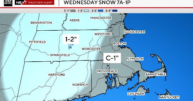
SNOW:
This will not be a big snowmaker for southern New England.
Boston to Providence and southeastern Massachusetts will see very little to no snow from this event.
A coating to an inch of snow and sleet is possible in Boston's close-by northern and western suburbs, including those towns around I-495 from Haverhill to Lowell.
This snow will all be washed away as the precip turns to rain Thursday morning, leaving no evidence that the snow actually fell.
Farther north and west is where the snow accumulation will likely stick around and where the higher amounts will fall.
We are expecting 1-3 inches of snow and sleet in northern Worcester county and southern New Hampshire, especially in higher elevated areas.
Three-to-6 inches are likely in portions of the Monadnocks, Berkshires and parts of central New Hampshire and Vermont.
Six to as much as 12 inches are possible in the northern mountains of New Hampshire and Maine, a real treat for ski areas before the upcoming long weekend!
ICE:
There is a moderate concern that some sleet and freezing rain will mix in with the snow to the north and west of Boston early Thursday morning.
This could create potentially dangerous driving conditions for a time and some ice accretion (minor, up to .1 inch) on surfaces is possible.
This is most likely to occur in places that are in between the all snow and all rain areas, including extreme northern Massachusetts and southern New Hampshire.
RAIN:
This will be a significant rain event for southern New England, many locations could receive well over an inch of rainfall in about a 12-hour timeframe.
This is certainly not enough to cause any major flooding, but some localized street flooding is likely.
Watch Melissa Mack's forecast:
WIND:
There is a wind advisory up for the entire Massachusetts coastline including Cape Cod and the Islands for strong, east winds 25-35 mph, including gusts up to 50 mph.
The greatest winds will occur between 6 a.m. and 2 p.m. on Thursday and this may cause some downed limbs and a few isolated power outages.
With the strong easterly winds and high astronomical tides, some pockets of minor coastal flooding are possible, but this is not expected to be a major issue on Thursday.
You can follow Terry on Twitter at @TerryWBZ.