Say Uncle! Dangerous Cold to Major Winter Storm...
No Way! Things are just starting to get interesting aren't they?! Exciting times to be a lover of weather. I feel sorry for those who feel the need to complain about the weather all the time...instead of enjoying the beauty of it all..good and bad.
Seriously...some people need to pick a season to complain about. Complaining about the weather all year any time it is not perfect is just ridiculous! Do you know people like this? I guess that is what makes some people different. I am usually pretty laid back with weather. I love it all. But after a 24 hour shift of forecasting and reporting in the weather, then to have to go dig out my car, then my driveway...well...Let me tell you what...Sometime I reaaaaally hate winter!
I have lived in Syracuse, NY, Bangor,ME and Boston, MA for my adult life. I have seen my share of snowfall and cold to last me a lifetime. I have earned my stripes to where I feel entitled to curse the season. I love skiing, sledding, forecasting Nor'easters...but winter is just the pits. Maybe because snow has just become work to me now. When I hear people romanticizing snow in the fall...I cringe. The season is too damn long! Despite all this, I still love the extremes this winter is bringing and this pattern is ready to deliver again!
I do not really have too much more to offer from what has already been said on these boards. We know it is going to be really cold, then we know a major storm is moving through during the midweek. Ptype and track still remain in question, but it is safe to say where this does remain all snow there is the potential for over a foot of snow easily. Let's go over the details again shall we?
Arctic air is on the move today. The Arctic front currently in Northern New England will push off the coast this afternoon. Ocean effect snowshowers for the Outer Cape could provide some minor accumulations...D-2". Significant cold air will settle into the region overnight with clear skies and diminishing wind. Lows drop to 0 at the coast to -20 to -25 in NW sheltered valleys. Many suburbs outside Boston drop down to -5 to -15 by dawn tomorrow. A wind chill watch is up through tomorrow morning for these NW valleys where the slightest breeze could make these temps feel -25 to -35 below zero. This becomes a dangerous cold if you are exposed to it for too long. Important to bring your pets in and limit outdoor exposure for too long Monday.
The record in Boston Monday is -13 set in 1882. We will not break that, but we will come close in Worcester early tomorrow. The record is -14 (1948). I expect lows around -11 to -13 at the airport. Monday will be a frigid day with Arctic sunshine and highs in the single digits with teens south of Boston and towards the coast.
Now where the Arctic high goes after it is through with us will be key in determining how our next storm is going to pan out. The classic winter storm set up is a High to the North over eastern Canada where it continues to feed cold into a deepening Low south of New England. I do not see that "classic" set up occurring which is one of the few reasons which leads me to believe there will precipitation type issues with this storm.
As we know this storm is coming out of the Gulf. It will be loaded with energy and moisture. There will be plenty of cold air ahead of the storm. That a lone is reason to be concerned.
A track along or just inland off the coast would bring rain over the eastern Carolinas and even a wintry mix/rain into the I-95 corridor of the mid-Atlantic. This track would dump heavy snow, on the order of 1 to 2 feet, over the Appalachians, Catskills, Berkshires, Southern Greens, New Hampshire into Maine. Snowfall rates would be intense with perhaps 1 to 2+ inches per hour. A track just off the coast would bring the heaviest snow to the I-95 cities all the way to the coast. The US GFS has this eastern outlier....and is likely too far east with it's track as the foreign models are trending further west...I favor these solutions for now. ..still several days away to fine tune. The stakes are high as usual.
With the high pushing off the coast and heading towards Georges Bank and Newfoundland...this is not the best setup for heavy snow in Southern New England. Also the NAO has gone slightly positive and that is more favorable for more western tracks and mixed events as well. Make no mistake about it, this storm will be powerful and may even reach near blizzard conditions again for some inland areas, NW of Boston. A period of strong onshore winds could lead to some minor coastal flooding too.
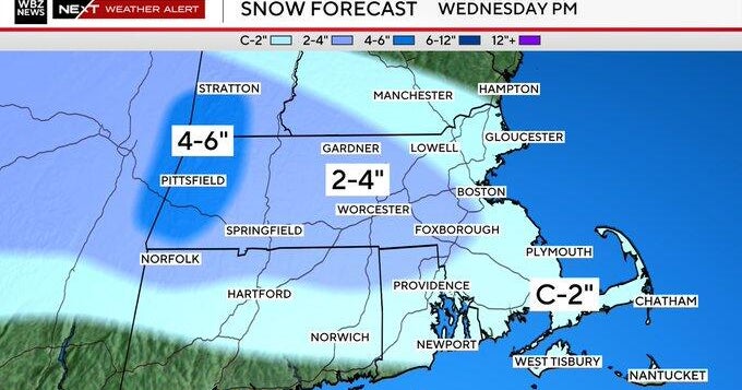
The storm has the potential to slow or shut down some major highways for a time and ground flights to create delays at most of the major airports..so this storm could have a major impact from the Mid-Atlantic to New England. I still think this low will hug the coast and track into southern New England...likely over Block Island and Buzzards Bay. The Heaviest snow will likely be found outside NW of the 1-95 corridor. I think Cape Cod will see the least snow, with a Mix of snow/sleet inland south with rain at the coast to snow again as the storm departs. Hard to say how much snow Boston, Providence to Worcester will get because of mixing concerns.. I feel good about the dumping where it remains all snow. Time will tell.
Lingering snow is possible into Thursday morning if the storm deepens or slows down any further. I hope I have made my thoughts clear...plenty of time to adjust and adapt thinking as the energy is just entering North America...currently sitting over British Columbia. Our models will now start to get a better handle on this now that it is over land. Extreme! Did I say I love winter? It's a love hate relationship.
