Rain Shifts From West Today to East Tomorrow
The focus of today's rain will be in western New England from the Hudson and CT Valleys. 4-6" of Rain fell in Northern New Jersey, Long Island and New your City this morning. This heavy rain is shifting north into CT and eventually into Western MA this afternoon. Showers will likely push into Worcester county. The closer to the coast you are, the drier you will be thanks to high pressure off shore. Despite a little light rain early, a good portion of the day should remain dry with temps in the mid 70's. Hard to completely rule out showers completely today for eastern sections...as a few showers could break off the main batch out west from time to time. Either way, a cloudy, humid and tolerable Sunday if you have to be outdoors in eastern MA.
Upper level winds are directing this moist humid flow up the eastern seaboard. Thunderstorms with torrential rain are forming from CT down to the Chesapeake Bay. A trough is digging in, which will allow a low to drift from the Ohio Valley towards the mid-Atlantic and track near the south coast of New England Monday and Monday night. A moist low level jet is providing the lift for heavy downpours in these area. As this shift east tonight...so will the axis of heavy rainfall.
Showers will still be mainly concentrated west during the evening hours, but there will be a tendency for the rain to start to fill in and become heavier for all later tonight...especially after midnight for those who live in eastern MA.Heavy rain is likely overnight through Monday AM before tapering to showers in the afternoon..still locally heavy rain will be possible inland. Cool onshore winds will keep temps in the upper 60's and Lwr 70's. Rain could be heavy for Monday mornings commute, so expect delays and the potential for urban flooding and heavy downpours.
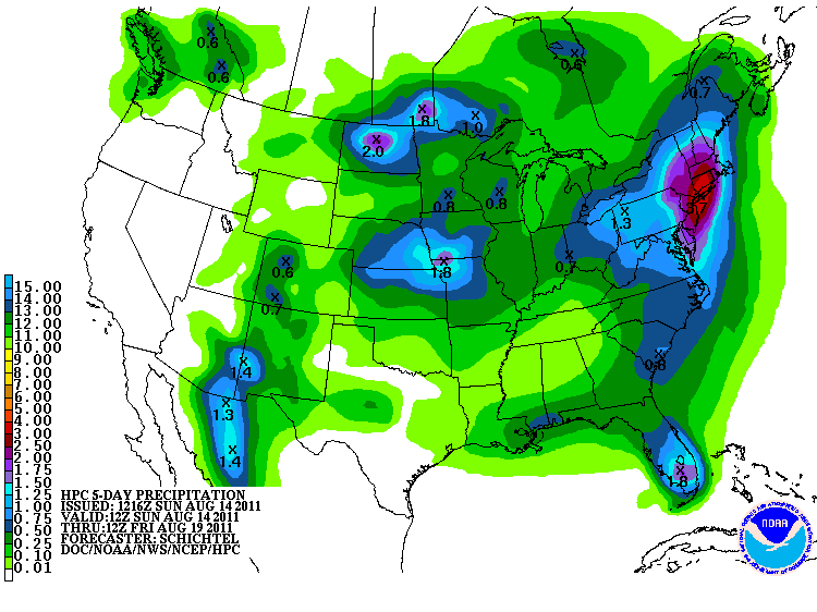
The low will weaken by Monday night with lingering showers, drizzle or fog and pull off the coast. A stationary front off the coast Tuesday morning with a secondary low following behind will keep abundant cloud cover as well as the risk for a few showers...but not nearly as wet as Monday. In fact we may start to see breaks of Sun by Tuesday afternoon if we are lucky. Cool onshore winds will keep temps in the Lwr-mid 70's...breaks of sun will be needed to reach the mid 70's. By the time this all winds down, there is the potential for 1-3" of rainfall, with locally heavier amounts up to 4+ near CT because of these tropical downpours.
High pressure will become fully established by Wednesday with temps back to near 80. Stay tuned to the Doppler Radar the next day or two before heading out just to make sure you know what you may be heading into!
Expected Rainfall in the next 5 days
