Quiet And Cold Through the Holiday Weekend
Find Eric Fisher on Twitter and Facebook

Full rain/wind Southern New England roundup here from the National Weather Service: Storm Reports.
Daily rainfall records fell at nearly every New England climate site on Wednesday, including Boston, Providence, Worcester, Concord, Windsor Locks, Burlington, and Bridgeport.
Well you couldn't have really drawn up a storm to behave as well as this past one did. Produced exactly what was expected - a widespread 1-3" of rain (biggest rain event since June), numerous gusts 45-63mph in SE Mass, hit the high temp in Boston on the nose, and it started/ended on schedule. I'd take that all winter long, although I doubt all the events will follow suit! That being said, it really wasn't all that much fun to have during a big travel time in the east. But it looks like many watched the forecast and planned accordingly, since traffic was not any worse than usual (in fact, it looked better than usual) on Wednesday. Hopefully you're now in a good spot and prepared to celebrate Hanukkah, Thanksgiving, or Thanksgivukkah.
The story for tonight is about the cold air flowing into the region. Temperatures will drop all the way back into the 20s for most towns overnight (low 30s Cape & Islands), and so that means wet areas will become icy areas. I think the most slippery travel will be across WMass where cold air arrives in conjunction with leftover moisture, but in eastern MA we may be able to dry out on a gusty breeze before the subfreezing temperatures settle in. Just be extra careful if you must drive overnight and into early Thursday, and watch out for iced over puddles and slick spots Thanksgiving morning.

Thanksgiving itself is looking quite chilly, with temperatures again diving well below average. The day looks mainly dry, although some snow showers may come down from time to time in the Berkshires and across southern Vermont. A feel of winter will be in the air, but I call that perfect eating weather. And if you're gathered with family and/or friends in a warm atmosphere with the aromas of delicious food and drink wafting through the house, you really won't be that concerned with what's going on outside! If plans include a morning 5k or heading to a high school football game, you may have different ideas. You'll definitely want layers, because with a gusty WNW wind the 'feels like' temperature will be in the 15-25º range. Those hits on the football field will hurt!

Shoppers will shiver if camping out Thursday night, because our temps will plummet back into the 10s. It doesn't look much warmer on Friday, with highs in the 20s to low 30s. Keep in mind the average high for this date is 47º. May not be idea for Black Friday deals, but I'd say it sounds pretty good Christmas tree chopping weather. Will definitely feel more like Christmas, when the average high is 39º. Not much change heading into the weekend, with lows in the 10s again Friday night and highs in the low 30s on Saturday with high pressure cresting over the region.
A light onshore flow, combined with an incoming clipper, should give us a mainly gray and wintry Sunday. A 'snow sky' may be the feature of the day, with light snow breaking out (perhaps light rain/drizzle for the coast instead). Doesn't appear to be anything you could shovel or plow away; merely snow to set the wintry mood. A damp air mass will hang around for Monday as well.
Skiing & Snowboarding...
You might think that the warm air was very bad news for ski areas, but I'd argue that that is not the case. They picked up some snow at the onset and yes, some of that washed away. But the rainfall was much needed to replenish reservoirs and ponds used for snowmaking. After a very dry fall, many of these were depleted. And with the upcoming pattern, they'll have plenty of opportunities to make new snow! Temperatures will be below average through at least the start of next week, and some natural snow will hit the slopes of WMass & VT Wednesday night/Thursday, and looking likely across NH/ME/eastern MA next week. It should end up a pretty decent start to the season. Bundle up if you're heading north this holiday weekend!

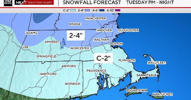
Tuesday is the next really interesting day in the forecast, when an ocean low may try to sneak back into New England and threaten with our first plowable snow event. The confidence on this is very low for now, but something we'll definitely be keeping our eyes on. Below is a look at the ECMWF snowfall output on the 12z run Wednesday. This is not an official forecast, just one of the products we look at to start gauging risk of snow.

Courtesy: WeatherBell
The other story for next week will be a massive Arctic Outbreak, with very cold air diving down across the NW United States. That air will ooze south and east across the Plains and down into the south throughout the week, until most of the country is seeing well below average temperatures. We've been talking about this overall cold pattern for weeks now here on the blog to end November and kick off December...a testament to how well long-range forecasting is coming along these days. It looks like the core of this Arctic Outbreak will stay to our west, but eventually will make its way in our direction as more modestly below-average air by next weekend.

Programming note: Be sure to tune in to our Eye on Weather Winter Preview Saturday night at 7:30pm on WBZ-TV Channel 4. We're going to take a look at some new technology going into our streets, visit communities battered by storms last winter, head out with the U.S. Coast Guard, and feature our own winter outlook for the months ahead. The timing is fitting, because Sunday is the first day of Meteorological Winter!