Plowable Snow Likely Monday Morning In Southern New England
BOSTON (CBS) - I admit it, I am all out of snow phrases, snow puns and cool winter weather terms.
If you have been following along this winter, we have had nor'easters, blizzards, bombogenesis, Norlun Troughs, Alberta Clippers, and, of course, the much media-hyped and my future professional wrestler alias: The Polar Vortex.
Check: Current Conditions | Interactive Radar | WBZ Weather Blog
And I refuse to say that March is going to "come in like a lion." I mean is there one person out there reading this at this point in our long winter who would find that amusing?
I didn't think so.
So, let's just get to it. Let me see if I can't dampen your weekend spirits just a bit with news of another snowstorm on the way.
THE PATH
Our next storm is currently spinning off the West Coast in the Pacific Ocean and looks quite impressive already. This storm is actually good news for many along the West Coast who have been suffering from a severe drought for more than a year. In fact, many areas in California should receive upwards of 2-to-4 inches of rain, which is excellent news for crops out there.
As it passes over the Rockies, the storm will weaken somewhat and gather a new identity over the Plains. By Sunday, the storm will take on more of a classic winter storm look. This is going to be a big snow-maker for a large west-east swath from Kansas City to Pittsburgh and then along some of the major cities of the northeast including Philadelphia, New York City and, eventually, Boston.
TIMELINE
Snow may start here as early as Sunday afternoon or evening from a band extending a few thousand miles out ahead of the actual storm center, but this would be very light, and would not accumulate.
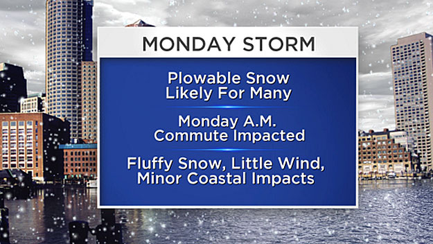
After 9 or 10 p.m. Sunday, the snow will become steadier and heavier and spread across all of southern New England. Several inches may already be on the ground before Monday morning's commute, which looks like a rough one at this point.
The heaviest snow and most accumulation looks like it will occur during Monday morning and into midday. This is when snowfall rates could reach 1-to-2 inches per hour.
During Monday afternoon, the snow will taper off from west to east and most of the accumulation should be done before the evening commute on Monday.
HOW MUCH?
There is still some uncertainty at this point with the storm sitting over the Pacific Ocean.
It is hard to get a real good sampling from the storm when it is not over land, because data is much more sparse over the open ocean waters.
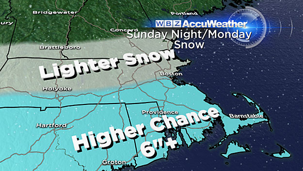
What I think is certain at this point is there will be a large swath of 6-to-10, perhaps up to 12 inches of snow somewhere in the vicinity of southern New England.
Actually, Philly and New York City are much more likely to be smack dab in the middle of this ribbon of snow than Boston.
The best chance of seeing totals in the 6-to-12 inch range in our area would be south of the Massachusetts Turnpike. Farther north, snow amounts would likely drop off quickly, perhaps 3-to-6 inches north of the Pike and even less into New Hampshire and Vermont.
Again, when this storm comes ashore Saturday morning, weather models should get a much better handle on it and these forecast amounts may need to be tweaked.
WHAT ELSE
This will not be a classic nor'easter, mainly just a snow day on Monday, with not much wind or mixed precipitation.
Tides will be at their highest point of the month on Monday (astronomically speaking), so there may be some minor splash over, but no significant coastal flooding is expected.
The high tides to watch would be around midnight Sunday night and more so midday on Monday.
After that, well, forget about it.
You don't want to know.
It looks cold and stormy for the first half of March at least. Perhaps something near our coast at the end of next week. Stay tuned.
Follow Terry on Twitter @TerryWBZ
MORE LOCAL NEWS FROM CBS BOSTON

