Offshore Storm Produces Light Snow
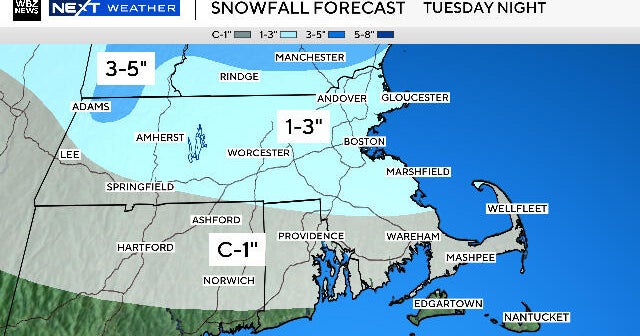
Many of us are waking up to cloudy skies but no snow. However, if you reside in southern Bristol and Plymouth Counties and western Barnstable County, you are waking up to a winter wonderland. These three specific locations will receive an additional 1-3" today and another 1-2" tonight. Other coastal areas will see a few flurries, but it won't be enough to accumulate. The best chance for more widespread flurries and snow showers will be Tuesday night thru midday Wednesday. There is the potential for a very light accumulation from this trough that swings by Southern New England.
There will be sunshine accmpanied by temperatures in the middle 30s to end out the week.
*** All eyes will be on a potential storm affecting us late this Christmas weekend. Currently, the EURO has a massive snowstorm this Sunday -Monday, while the GFSx shows light snow skirting southeastern Massachusetts Saturday night thru midday Sunday. As we have learned with the current weather situation, the models will be indecisive throughout the next several model runs before we can nail down the storms system's exact track and snowfall potential.
Happy Last Day of Fall...astronomically-speaking.
Melissa :)