Nor'Easter Forecast: Snow Possible Wednesday Evening
BOSTON (CBS) - A very tricky forecast for Wednesday and Thursday as a complex nor'easter is headed our way.
Many weather models overnight have trended a bit farther east with the track of the storm and this would have large implications.
Check: Current Conditions | Weather Maps | Interactive Radar
If this trend continues and this nor'easter tracks well offshore this would be a good news-bad news situation.
First the good news. Because the storm is not as close to our coastline, the wind damage and coastal flooding threat would be somewhat diminished, as would the rainfall totals in eastern Massachusetts and snow totals well to the northwest.
The bad news? This track would mean a colder solution and likely bring some accumulating snowfall very close to the Boston area.
Gallery: Nor'easter Forecast Maps
Here is how I see it breaking down given the latest model data:
TIMELINE
Clouds arrive by dawn on Wednesday. Winds will increase steadily during the day and precipitation arrives late afternoon, early evening.
The brunt of the storm would be Wednesday night into early Thursday morning. While we would still be under the influence of the storm through early Friday, it would be rapidly weakening during the day Thursday and Thursday night.
COASTAL CONCERNS
This is a different animal than Sandy for many reasons.
First, it is not nearly as intense or destructive. Also, the wind direction will primarily be out of the northeast. During Sandy the winds were east-southeast. Therefore, the greatest concern along the coast would be east facing beaches, not the south facing beaches as with Sandy.
The high tides are not astronomically significant so we are only expecting minor coastal flooding around the time of high tide Wednesday evening (about 5 p.m.). A storm surge of about 2 feet is likely along east facing beaches with seas building to 15-to-20 feet just offshore. Thursday morning's high tide (around 6 a.m.) should be even less significant, just expecting a 1-1.5 foot storm surge and very minor coastal flooding. As with all nor'easters some beach erosion is certain.
WIND
The peak wind gusts are expected to arrive late Wednesday into Wednesday night and be located along the East Coast and in southeastern Massachusetts. Sustained winds in those areas should be around 30-to-35 mph with gusts as high as 60 mph or a bit higher.
Inland, gusts should remain between 20-to-40 mph. Some tree damage and power outages are likely but nothing near the scope of Sandy. Winds will remain gusty on Thursday but will slowly diminish.
PRECIPITATION
Rain does not look to be a significant factor with this nor'easter, as the heaviest will likely remain offshore.
Snow, however, is a different story.
This may be the biggest change to the forecast today.
With a forecast track projected to be a bit farther east, this will allow for more cold air to be drawn in and for more variety of precipitation type.
Rain will move in early Wednesday evening but the intensity for the first several hours will likely cause some evaporational cooling to occur in areas just west of I-95. This essentially means that heat is removed from the surrounding air due to the evaporation of the precipitation falling into it.
The bottom line - temperatures will quickly cool from the low 40's to near the freezing mark Wednesday evening, causing rain to change to wet snow.
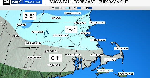
Heavy, wet snow may fall for several hours Wednesday night west of I-95 and a few inches could accumulate, especially on elevated, cold surfaces.
The ground is obviously somewhat mild, so it will take a certain intensity for the snow to accumulate. A lighter snow would likely have a harder time sticking.
We will have to watch for the development of a heavy band of snow, which could set up somewhere not too far north and west of Boston. Within that band snow could accumulate to higher amounts.
It is important, as always, to stay tuned to updated forecasts.
Any slight adjustment in track to the nor'easter could have large consequences in the end result.
You can follow Terry on Twitter at @TerryWBZ.


