More Spring Snow on the Way...
Sorry for the late post, we've had problems with the blog this evening...maybe you've noticed...
Well the pattern is reverting back to Mid-Winter so it's only fitting that the models revert back to their Mid-Winter form too. Basically the NAM and GFS have flip-flopped with the GFS now the most robust model and the NAM backing off pushing the precip mostly well south of us.
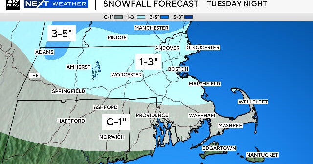
As of now, I still prefer the lighter amounts...not as light as the NAM but more like the EURO. Obviously, this needs to be watched very closely...especially if we get the well-defined closed low at 850mb like the GFS is depicting, that would create significant overrunning precip and much higher amounts. But with the primary vort going so far to our south, it's hard to believe the surface and 850mb low getting close enough to us for the heavier snows. Regardless, the timing is good for Springtime snow accumulation...at night so roads this time around will likely get snow-covered or slushy.
The upper level cut-off will keep an unstable atmosphere around and that along with cyclonic flow will create numerous snow showers even into Friday.