What's Behind New England's Streak Of Mild Winter Weather?
BOSTON (CBS) -- Weather is fascinating. I know I know, easy for me to say, I am a meteorologist and naturally, it is my job and passion. But, indulge me for a few moments…grab your favorite beverage, snuggle up next to Fido and see if you don't agree with me after reading this entire blog. If nothing else, I will leave you with a few juicy weather nuggets you can use to amaze your family or co-workers!
No doubt, we are in a boring stretch of January weather right now. Some of you, I am sure, are more than happy to cross some winter days off the calendar without any major snow or cold. Others, ski areas & winter sports lovers included, would call a two-week dry stretch in January a waste of wintertime. Either way, the boring weather continues (for now), so, what better time to dig through the weather and climate databases and search for interesting and fun weather happenings!
It's been mild…no, really it has!
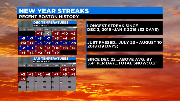
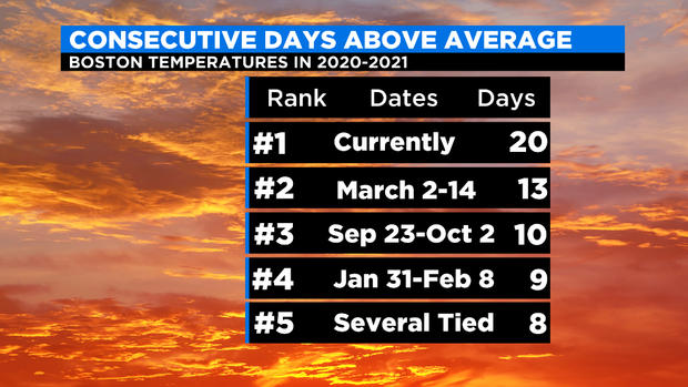
It may not seem like it, but it has been pretty mild lately for this time of year. In fact, as of this writing, Boston has had 20 consecutive days with temperatures above average! Can you believe that? The streak started back on December 22, continued with the largest daily departure on Christmas Day (+18.2 degrees), and has gone all the way through January 11. And, the streak will likely last for several more days through this week! Why haven't you noticed? Well, the average daily temperature departure has only been 5.4 degrees. When average daily high temperatures are 36 degrees (like today), 5 more degrees is nice, but not all that noticeable. Kind of like when in summer the average is 80 and you get an 85-degree day, not all that noteworthy. But still, 20 days in a row! That has to be some sort of record! Well, glad you asked…
The current streak of 20 days in a row of temperatures above average is easily the longest such streak in the last year…Second place being March 2-14 of 2020 (13 days). Looking back further in time, we just beat out the 19-day above-average streak from July 23 through August 10 in 2018. In order to find a streak longer than 20 days, we have to go back all the way to Dec 2 – Jan 3 of 2015-2016 (33 days)!
When I found that little nugget it struck yet another cord…interesting that the prior longest streak happened in Dec-Jan, bridging the New Year, just like this current one. That got me thinking, and searching…What I found was truly mind-boggling!
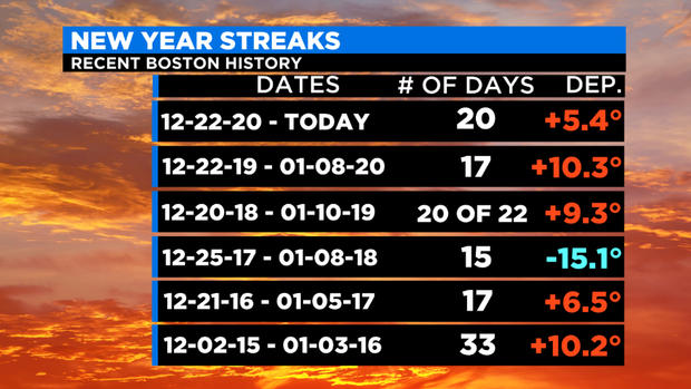
It turns out this same phenomenon has occurred for the last 6 years! Going back to the winter of 2015-2016, each and every Dec-Jan has had a significant and consistent temperature streak in Boston.
- 2020-21: 20 days and counting, 5.4 degrees above average per day.
- 2019-20: 17 days and nearly twice as mild as this year. Not to mention just three days after the streak we had two record warm days (Jan 11: 70 degrees, Jan 12: 74 degrees)
- 2018-19: We had two slightly below average days which fouled up the streak but still, 20 of 22 days, spanning the New Year, and a daily departure of 9.3 degrees!
- 2017-18: Yet another streak but this one was the exact opposite! 15 straight below-average days with an incredible daily departure of more than 15 degrees!
- 2016-17: 17 straight milder than average days, +6.5 degrees per day.
- 2015-16: The granddaddy of them all, the start of a 6-year streak…A whopping 33 consecutive above-average days, 10.2 degrees per day.
So how do you explain this? Is there something going on atmospherically between December and January that might lead to a stalled out or continuous pattern? Well, I have a few theories:
Above-average days are becoming more and more the norm as the planet continues to warm. This is thanks in large part to our Oceans being so anomalously warm. Look at any comparison of Ocean temperatures now vs. a few decades ago and you will see nearly the entire Ocean covered in red. The northern Atlantic, off our Coastline is one of the areas that has warmed even faster than others. So, if you have a milder Ocean just to our east, naturally that will temper the cold early in winter. Also, if you have days with prevailing winds off the Ocean (as we do so often), and the surface Ocean temperatures are several degrees milder, naturally land temperatures will follow suit.
Another possible factor is the Arctic. Ice is melting at a rapid pace to our north. This has generally led to milder conditions across the North Pole, especially in winter. Some meteorologists believe that a milder Arctic is leading to more large scale disturbances in that region. More Sudden Stratospheric Warming episodes that I wrote about just last week and more Polar Vortex disruptions. This then leads to big undulations in the Jetstream across mid-latitudes (where we live) and large blocking tends to set up which can stall out the typical west to east changeable Jetstream for days and weeks at a time. So, you get persistent weather for long stretches…some areas may end up milder and drier while others have storm after storm and a blitz of snow and cold (see March 2018 or Feb. 2015 in New England).
I believe that one of the big ramifications of our changing climate (at least for now) will be more and more of these "streaks". This, undoubtedly, will lead to more extremes:
- Dry streaks, like we had last Summer-Fall and back in 2015-16
- Snow and cold streaks like we had in February of 2015
- Stormy streaks like we had in March of 2018
- Boring streaks like we are currently in
- And, of course, warm streaks…they are becoming so frequent it is hard to keep track
So those are some weather thoughts on an otherwise boring January day in a boring January week. My guess, it won't be long before we are discussing streaks of a different kind, and perhaps then we will all be wishing for a few boring days…
