Massive Hail & Possible Tornado Hit The Northeast
Find Eric Fisher on Twitter and Facebook
Add some cold air aloft, strong shear at the surface, a touch of CAPE, and you've got the ingredients for a severe supper. There were some pretty incredible storms around the Northeast and Mid-Atlantic Thursday afternoon, including several mesocyclones (rotating thunderstorms) that produced massive hail and potentially a tornado, too. Fortunately for us, the air is much more stable in Southern New England (thank your onshore flow for that). But here's a look at a pretty incredible day in photos around the region.
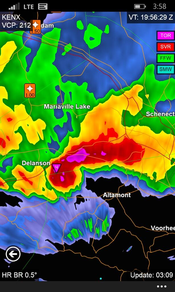
This was the storm that really got everyone's attention, and with good reason. A classic supercell formed NW of Albany, NY - near Duanesburg and Altamont. This storm produced huge hail and very likely, a tornado too. The National Weather Service in Albany, NY is not going to send out a survey team until Friday, so it is not a confirmed tornado yet. However, I can say that by looking at the radar signature, it's very likely that one occurred. For a couple scans there was a TDS (tornado debris signature) - where correlation coefficients were very low near where the tornado would likely be. There was a tight velocity couplet as well, and the radar site was only about 10 miles away. That means it was measuring velocities at very low levels, not higher up into the storm. I will be surprised if the NWS doesn't confirm it as a tornado.
Here is a home that was certainly destroyed by the storm. It doesn't appear to be a mobile home, but does not appear to be of sturdy construction either. There were, for a time, 2 people unaccounted for from this home - but it is now reported that they have been found and are O.K. Looking at the damage to this structure, coupled with the radar signature and the tree damage around the home - again I would be surprised if a tornado was not the cause.
This photo shows the depth of the tree damage in the same area. Nearly all of them snapped off either at ground level of halfway up. There's a *chance* straightline winds could cause this, but I am very doubtful.
High profile vehicles are most at risk when damaging wind gusts are around, and here you can see the result on I-88. It's not clear if a tornado caused this, or if it was just a damaging downdraft from the thunderstorm responsible for the tornado. Radar indicates the storm become downdraft dominated as it weakened and veered off to the south.
This hail stone is about as big as any you'll ever see in the Northeast. We don't often get instability, strong updrafts, and shear all together to produce the mesocyclones that can keep these big stones afloat in a thunderstorm. It was measured around 4" in diameter - dangerous for you and your car! I'd hate to be parked under this storm. Some insurance adjusters are probably getting a phone call tonight.
Interesting garden in DeLancey, NY. The window box is completely full of golf ball sized hail! Not quite as large as the stones above, but still extremely impressive. These too can leave dings in your car, and certainly wouldn't feel good if they hit you in the noggin.
This storm in Pennsylvania absolutely bombed a main road in Wyomissing, PA (just west of Reading, PA). If you look close at the photo, you can see a couple of things. One - the trees are almost completely defoliated. There are still some leaves attached, but most of them have been shredded by the hailstones. Two - the fog rising from the ground. The damp air is cooled by the ice, and condenses near the ground into a fog. Unbelievable stuff!
This photo reminds me a little of the Blizzard of '78, only with hail instead of snow! The fog has become dense at this point as the ice cools down all the air around it. This is likely a scene these people will never forget!
