Long Duration Midweek Storm Will Have Major Impacts For Coast
BOSTON (CBS) - What a stretch it has been. Storm after storm since early February has battered our coastline, dumped near record amounts of snowfall, brought blizzard conditions, and have many New Englanders wishing for spring.
Unfortunately we are under the gun once again and much like the other storms in this late winter parade, it will also have many unique characteristics and set of concerns.
Check: Interactive Radar | Current Conditions | Weather Blogs
First and foremost, this is going to be a long duration event…much longer than any of our previous storms this winter. The first drops and flakes will fall around or just after dinner on Wednesday, starting a period of about 48 hours of wind and precipitation.
The steadiest precipitation will likely arrive after midnight on Wednesday and last through about 1 p.m. on Friday, about 36 hours…with just some light snow flakes and rain drops before and after that time frame.

The actual center of the storm will be much farther south than what we would normally see in a classic Nor'easter. However, the storm is going to be so powerful, gaining strength as is hits the warm Atlantic Wednesday morning, its effects will be felt for hundreds of miles in every direction.
It may actually resemble a hybrid-type tropical storm. Many times when tropical systems reach our latitude they tend to flatten out and widen their wind and precipitation fields. There will likely be an eye-like structure off the Delmarva coast later Wednesday into Thursday, yet the heaviest precipitation will likely be displaced a good distance from that "eye."
The center of the storm will essentially be the engine or the "heart" continually spinning heavy bands of rain and snow in a counter-clockwise fashion from well out over the Atlantic into parts of Southern New England. The rain and snow will come in waves and heavy bands, off and on for nearly two full days.
The rain/snow line is obviously crucial with this storm. Right now it appears that it will setup just to the north and west of Boston.
Right now it appears that it will setup on the immediate coast, perhaps waffling back and forth in the Boston area or just to the South. This is slightly colder than our original thinking.

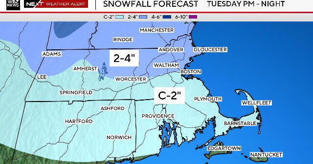
Therefore we have edged our snow forecast up a bit as well, now going for a widespread 4-8" OR MORE from Boston to Worcester and all of Metro West into Southern New Hampshire.
This will be a very heavy and wet snow, leading to the potential for power outages when combined with strong, gusty winds. Slightly lower amounts will be found closer to the South Shore, along the coast down there, 2-4" of a sloppy wet slush. Over Cape Cod and the Islands, just a coating to 2" of slop, mainly rain.
What does the "or more" on the 4-8" mean you ask? I would not be surprised to see final snow amounts around a foot in some western 'burbs when all is said and done. But, it will likely never look like a foot due to the compacting of the heavy snow. You would have to be a very diligent snow measurer to get an accurate number from a wet snow like this.
This would mean lots of heavy rain right along the coastline, including Boston and Southeast Mass. Just to the west, around Route 128, there will be periods of heavy rain and also heavy, wet snow. The best chance of seeing all snow would be in elevated areas and locations north and west of 495.
Spots like Fitchburg in Northern Worcester County, could see well over 6," perhaps upwards of a foot of very heavy, wet snow. Once again, there will be a lot of actual precipitation with this storm, but with temperatures being so marginal, close to 32, snow will not accumulate very quickly. Snow amounts will taper down quickly the closer to the coast you get. There may be several inches near 495 and near nothing close to the city.
However, there remains a significant chance that the rain/snow line may be a bit farther east, this would bring the heavy, wet snow right into Downtown Boston, unfortunately this is a scenario that we cannot yet rule out.
The greatest concern with this event will be along the coastline.
There will likely be a significant impact for the entire Massachusetts coast with severe beach erosion and flooding. Our coastline has already been battered this winter and changed forever…this storm will only compound the issues. No doubt that when you head to the beach this summer, many parts of our coast will not look familiar to you, it is being changed forever.
Some of our most serious coastal flooding and erosion have come during long duration events, much like this one. The problem is when you have persistent, strong onshore winds for several high tide cycles in a row, the water has nowhere to go, never gets a chance to go out. While tides are not astronomically very high later this week, the long duration of the storm, lasting for at least three high tide cycles will build the seas higher and higher.
Storm surge values will be around 2.5 to 3 feet for each high tide (7a.m. Thu, 7p.m. Thu, 8a.m. Fri). Each tide will become more problematic than the last with the surge being unable to drain out to sea. The seas will build to around 25 feet just offshore on Thursday. Given all of this, minor to at least moderate coastal flooding is being forecast for the duration of this storm, with the potential for some pockets of major flooding.
As always I would stress the importance of staying tuned to forecast updates. The ultimate track of the storm will have huge impacts on the rain/snow line and coastal damage. Some fine tuning to the forecast is inevitable in the next 24 hours. Please take this storm threat seriously, especially if you are a coastal resident…you should begin to make preparations immediately.
You can follow Terry on Twitter at @TerryWBZ.
