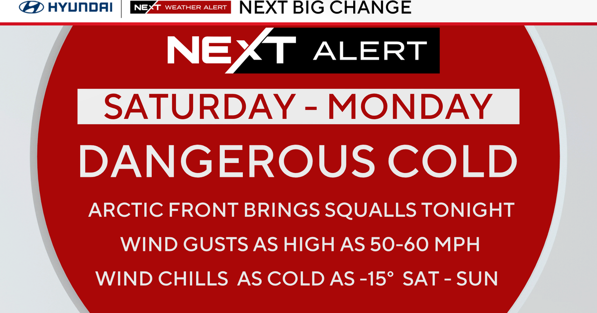
Layers Needed...
The backdoor front has progressed through the area and has knocked temps from around 60 degrees to around 40 degrees in just a few short hours. Many who were wearing shorts early this afternoon are now shivering and throwing on layers! Those layers will come in handy these next few days as onshore flow will rule the roost keeping temps in the lower 40s and the low clouds, fog and drizzle machine going strong.
In a pattern like this, low-level moisture kind of regroups and recharges during the night under the cover of darkness and during the days, sometimes, the sun can burn through the low overcast leading to breaks of sunshine. Areas with the best chance to see the sun are usually well inland away from the colder ocean water.
I don't expect much to change on Friday as the onshore component will still be present. But, finally by Saturday, after a gloomy start in the clouds high pressure will work down from the north and shove the clouds out of here for the afternoon and evening...this will allow temps to climb out of the 40s and into the 50s.
By the end of the weekend, that same high will have shifted offshore and SW flow will once again commence leading to an amazing finish to the weekend with highs in the mid to upper 60s! Overall, most of next week will be warm too...in some cases even warmer than this week! There is still some question about Monday on whether a backdoor coldfront will slip through during the day or not...it will mean the difference between highs in the 50s and highs in the lower 70s. There doesn't, however, seem to be any question about the warmth for Tuesday and Wednesday of next week...70s Tuesday and 80+ on Wednesday. Tuesday is the first day of Spring by the way...kind of funny when it will be feeling like Summer. By the way, the record for next Wednesday is a very difficult to attain 83 set back in 1921.