Just a few hours to go, then relief!
I know there are plenty of people who just love the hazy, hot, and humid weather of summer. But if you're one of those looking for a little less humidity to deal with, then you're in luck. A cold front is set to swing through on Tuesday and put an end to this unusually steamy weather pattern we've been dealing with since last week.
Currently there's a huge gyre of low pressure swirling north of the Great Lakes, with a dome of dry air in the middle of the country and a big plume of tropical moisture streaming up the East Coast. Check it out on Water Vapor imagery: http://www.ssd.noaa.gov/goes/east/eaus/flash-wv.html
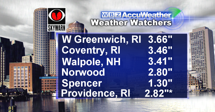
That tropical plume helped to produce more monster rain totals in spots today. The main area affected was Rhode Island, where some folks in Cranston required water rescues and local road closures dominated the afternoon. In Providence, the 2.82" of rain recorded was a new daily rainfall record for September 2nd. That being said, some places enjoyed breaks of hazy sunshine! Much like Saturday and Sunday, the rain was very hit or miss.
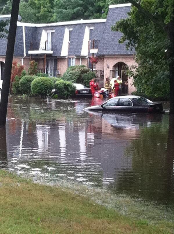 <-- Flooding swamps a neighborhood in Cranston, RI
As we look forward, the big story is our cold front. It is delivering severe storms to New York State and northern Pennsylvania tonight, but when it comes to storms for us it will all be about timing. I think the morning will be mainly dry, albeit still very humid. Outside of an isolated shower or two, many kids going to the bus stop for the first time this season won't need the umbrellas. However, they may want to bring them for the trip home. Most models are timing this front to arrive in the Metro West - Boston area by midday. The early it arrives, the smaller the chance for severe storms. If it comes a little later, then instability will have a chance to return and storms will be able to grow taller into the atmosphere. There will also be more wind energy and shear tomorrow, which could help produce hail and gustier winds than we've been dealing with.
All that being said, I'm leaning toward the earlier timing of the front. This would confine most of the shower/storm activity from Metro West - points east, with very little rain (if any) west of there. The highest chance of heavy rain/storms will be the 128 corridor and for Cape Cod/the Islands. The best timing would be noon-6pm. For those traveling to western Massachusetts I expect a mainly dry afternoon with more sunshine and a gusty breeze turning to the WSW.
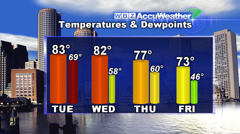
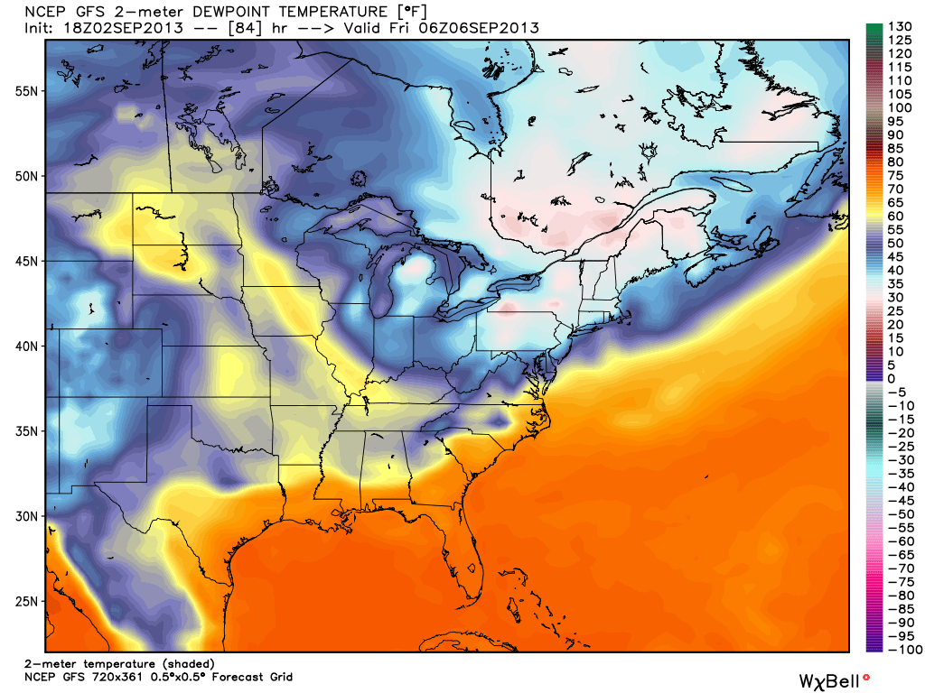
Once the front moves off the coast Tuesday night, the drier air will filter in! This graphic below tells the story. Temperatures will step down each day, and by the end of the week some seriously dry air will head on down from Canada. In fact, dew points could drop into the 30s for interior New England Friday morning! Perhaps even a sheltered valley way up north could see a spot of frost, but it's still a bit too early to say for sure on that. Either way, the end of the week looks much cooler and will feel a lot more like fall than the South Florida weather we've been seeing lately.
Below is a look at the dew points for Friday morning. Can you say fall?
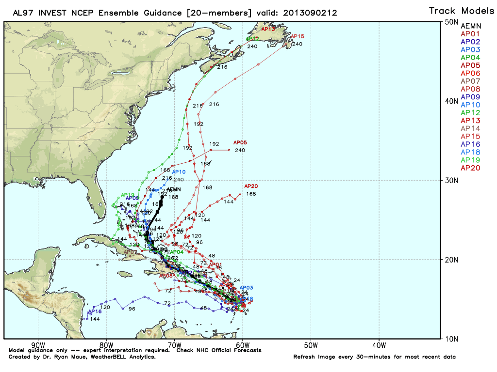
So far as the tropics go...we're still keeping an eye on Invest 97L. It's looking elongated as of this writing at 7p Monday: http://1.usa.gov/18jyvUp and rapid intensification is not expected. However, environmental conditions are still relatively favorable over the next 72 hours. Most models track the wave in the general direction of Puerto Rico and Hispaniola, then drift it off the East Coast (very few develop it into anything significant). A general long-wave trough over the Northeast should keep us protected from anything that may try to organize. There is also Invest 98L just off the coast of Africa, but that is not expected to post a threat to the Islands or the Lower 48.
