'Intense Burst Of Snow' Coming Saturday Night
BOSTON (CBS) - Uncle! Mercy! I think we are all about ready to tap out and move on from this winter.
The weird thing is, we've only had 49.4 inches of snow in Boston, a little above normal, but we average nearly 44 inches for an entire season.
Is it me or does it seem like we have had 100 inches? If this is what 49 feels like, what's a "real" winter like? Like back in 1995-1996 when we had a record 107.6 inches of snow. I was here then and have some memories of it, but at this point I couldn't imagine getting nearly 60 more more of snow this winter. Could you?
Anyhow, I am sure you have heard by now, there is more snow in the forecast and no rest for the weary.
Check: Current Conditions | Interactive Radar | WBZ Weather Blog | Forecast Maps
Our next storm is already on the map, about 1,500 miles away, dropping snow in parts of Iowa, Missouri and Illinois. It will sweep through Georgia and the Carolinas Friday night and then undergo a rapid intensification as it hits the Atlantic waters, something we call "bombogenesis."
Sounds scary right?
It is basically a fancy term for what happens to a storm when it undergoes a rapid drop in pressure in a very short amount of time. Essentially it goes from a relatively weak, regular old storm, to a monster, nor'easter-type system. I am sure most of you have seen the Incredible Hulk? Just think of mild-mannered Bruce Banner. One minute he is just a regular old doctor, then he gets angry and the next minute he is a big green monster - bombogenesis!
Onto the details.
TIMELINE
This will be a fast moving, intense burst of snow focused during Saturday night along our coastline, essentially, a 6-to-8 hour window where we will accumulate snow very rapidly.
During Saturday afternoon, some light rain or snow showers will start in southeastern Massachusetts, no accumulation, and not really associated with the real heart of the storm.
Between 7 p.m. and 2 a.m., the storm will make its closest pass to the New England Coastline and it appears as though we are going to catch the western fringe of it explosive development.
This is a real tricky forecast. Literally 25-to-50 miles one way or another will be the difference between very little, if any, snow and 6 inches or more. There will be a very sharp gradient between heavy, blizzard-like snow conditions and light, meaningless snow.
ACCUMULATION
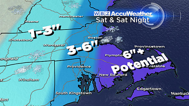
The best chance of getting into the heavy stuff would be locations farthest east in Massachusetts - our immediate coastline, Cape Ann and especially southeastern Massachusetts and Cape Cod. This is where 6 inches of snow is likely Saturday night. In fact, if the banding gets real intense, snowfall rates could reach 1-to-2 inches per hour.
There is a chance that as much as a foot of snow could fall in about 6 hours in some localized areas. This bullseye might be near the southern Plymouth County coastline and over Cape Cod.
Farther north up the coast into Boston and over the North Shore, 3-to-6 inches of snow are likely. These areas will be right on the edge of the most significant snow banding.
Just a few miles west, around Route 128 and 495, just 1-to-3 inches of snow are expected with only some stray flakes back in Worcester County and southern New Hampshire.
By the time you wake up Sunday morning, the storm will be long gone, wreaking havoc up in coastal Maine and Nova Scotia.
Then we get a few days of a break before our next chance at snow on Tuesday - yup, one more.
There are signs that after Tuesday we will undergo a pattern change which could lead to milder days. Temperatures will soar well into the 40's, perhaps 50+ later next week.
The end to our season-long hibernation is in sight, we just have shovel and plow our way through the next few days to get there.
Follow Terry on Twitter @TerryWBZ
MORE LOCAL NEWS FROM CBS BOSTON
