Hurricane Maria: Where Is It Going Next?
BOSTON (CBS) - Many New Englanders have a special relationship with the sea. We respect its power and marvel in its beauty. Storms bring out the best and worst of the ocean and there's been no shortage of 'wave tourists' over the past couple days to breathe it in.
Jose has a couple more days yet to churn the waters, but there will be no rest for the tireless Atlantic. With Maria approaching a fresh swell is on its way next week. Will it be more than that?
Let's take a look at the players on the field.
For starters, Jose is going nowhere fast.
It's trapped between a large subtropical ridge in the Atlantic and another huge ridge that's built up over the Great Lakes. With no room to move, it's... ah... not moving. In fact it'll even drift west through Friday and then eventually spin itself out and dissipate this weekend.
Until that happens, northeast winds will keep gusting 35-60 mph at the coastline before winding down Friday night through Saturday. That's why erosion was the main concern with Jose - the continual whipping up of surf over multiple days on strong winds. Ballston Beach was breached again on Thursday, and we're likely to see more rough surf until late Saturday.
But Jose may also lend us a helping hand. A lesser of two evils, if you will.
Tropical systems 'feel' weak spots in the atmosphere in the absence of strong steering currents, and Jose is providing a weakness between a big eastern U.S. area of high pressure and one out over the Atlantic. Maria will feel a gentle tug north because of this, traveling the periphery of the Atlantic ridge and toward Jose, pulling it away from the Bahamas on Friday and Saturday.
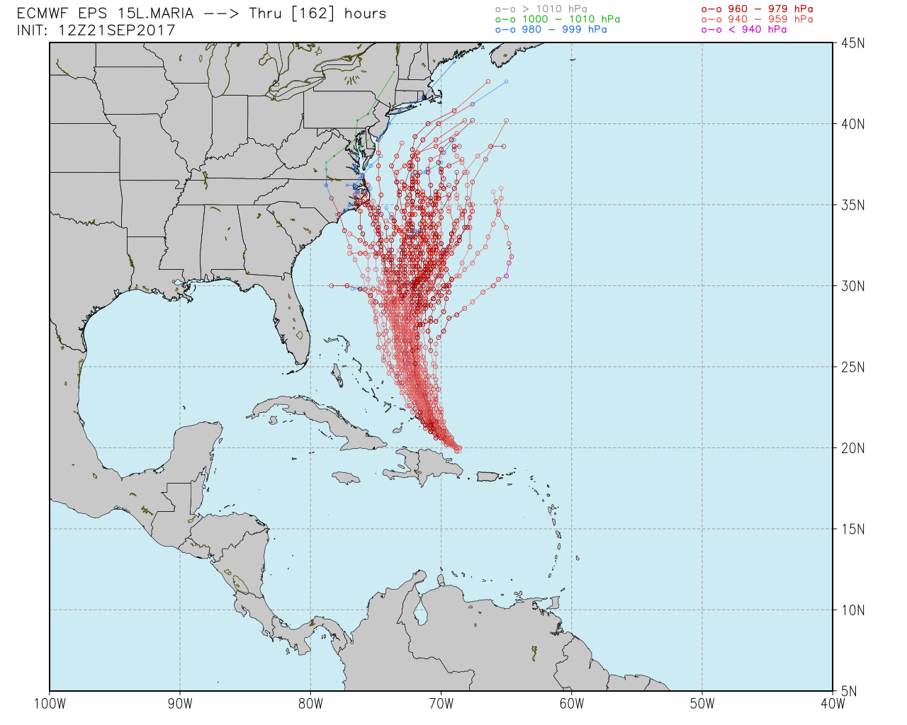
You'll also notice on the map above that there's a little upper-level low over the southeast. I think this is the only 'fly in the ointment' for Maria over the next couple of days. There's an outside chance that if Jose is not strong enough leading into the weekend, Maria will feel a stronger tug from this southeastern low and end up a little farther west. That would put the Outer Banks of North Carolina at risk for some impacts heading into next week.
That's why the Euro EPS (ensemble prediction system) has some solutions toward the North Carolina coast.
The steering currents at play are a little gentle/tenuous over the upcoming 72 hours. I wouldn't be overly confident about the future track of the storm until Saturday or Sunday when it becomes clear which 'tug' will be dominant - Jose or the southeast low. Locally we're rooting for Jose to hold on! The longer it maintains a decent intensity and circulation, the more it'll chip away at that ridging and continue to guide Maria north-northeast instead of northwest.
As we head into early next week, Jose will be dead and there won't be much of a strong steering current around, so Maria will slow down and move gradually north.
The official hurricane center forecast is for gradual weakening at this time as it will be traveling through some somewhat cooler waters churned up by Jose and will be experiencing some wind shear as well, though I feel like may be able to hold on to Cat 2 or 3 status for a good amount of time off the eastern seaboard.
Then, we await a strong trough that will be diving east across the country.
Though the track may end up similar to Jose, the end game around our neighborhood will be much different. Jose has been trapped under a ridge, Maria will get blasted out to sea by this trough. Thankfully it's a broad trough and not a digging one (a digging negatively-tilted trough is a great way to yank a hurricane into the east coast) so it all comes down to timing.
The westerlies will come in strong late Wednesday into Thursday and quickly usher Maria out farther into the Atlantic. It's just a matter of how close it gets to us before that happens.
Either way, I don't expect a powerful hurricane on approach here.
Jose is upwelling already cool waters and Maria won't be coming north at a fast clip (which is how we get our stronger storms). And regardless of exact track, the waves will be nearly relentless. Swell from Jose will be subsiding on Sunday, but then rising again by Monday night as waves from Maria propagate north.
Then for Tuesday through Thursday we'll have more high surf and powerful waves coming ashore (though with lower astronomical tides than Jose). It'll be very warm in our area Sunday through midweek and nice beach weather, so be advised rip currents and rough surf will be an issue again.
So in conclusion, a track just offshore is most likely but we can't feel too comfortable about it for a couple more days. And once Maria heads out, the hurricane risk in the Atlantic quiets down for a while. Heading into October it looks like the focus may turn more toward the Gulf of Mexico and Caribbean, but let's hope for a breather!


