30 Years After Hurricane Bob Hit, Southern New England Still Waiting For The Next One
BOSTON (CBS) -- The dog days of August 1991 were violently interrupted when the most powerful hurricane in decades reached the shores of New England. Hurricane Bob, arriving earlier than any other hurricane of record in New England, brought damage some had not seen since Carol and Edna in 1954. And the region hasn't seen a landfall in the 30 years since.
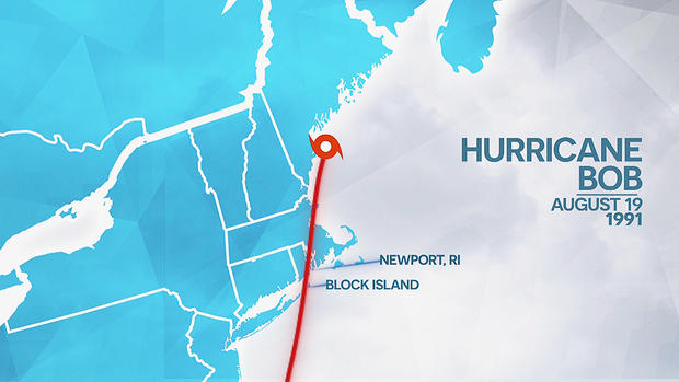
Bob had its start in the Bahamas, where it quickly gained strength and accelerated northward. Briefly gaining category 3 strength, it would go on to weaken slightly to a category 2 before the eye crossed over Block Island in the early afternoon of August 19th. Further landfalls would come in Newport, Rhode Island and Rockport, Maine.
Many of the region's strongest hurricanes are fast movers, and Bob was no exception. With a forward speed of over 30 mph, the worst wind and wave action blew through in just over an hour. The track over southeastern Massachusetts would put Cape Cod and the Islands in the worst possible position (east of the storm's center). Gusts up to 125 mph were notched in Brewster and North Truro, with sustained winds of 100 mph in Provincetown. The extreme winds were enough to send all of Cape Cod off the grid. Power outages were extensive, and in many cases would take days to repair.
While winds blew down trees and damaged homes, a destructive storm surge was pushed into Buzzards Bay. The head of the bay would fare the worst, with Onset, Bourne, and Wareham dealing with a 10-to-15 foot surge which wiped out dozens of homes from Mattapoisett to Falmouth. A 40-foot wide channel cut through Popponesset spit in Mashpee, and the Tobey Island bridge was destroyed in Bourne.
Bob was no picnic for boat owners, with hundreds either destroyed or beached when Bob powered through. And on Martha's Vineyard and Nantucket, dozens of feet of shoreline disappeared in a couple of hours. The south-facing shores endured severe erosion thanks to wave action and surge. In the end, Bob would carry a price tag of more than $1 billion in damage.
Amazingly, there was not a lot of hype for the storm. Many did not even know it was coming or took it seriously until the day it arrived. With a landfall in mid-August, it was still full tourist and vacation season with no cell phones or widespread internet to get information. Even the National Weather Service would report an eerie lack of interest or ringing phone lines the day before landfall, which seems unfathomable in today's age. The sudden realization that a powerful hurricane was about to hit led to a sudden rush of evacuations from Cape Cod, and an 11-mile backup at the Sagamore Bridge.
Bob is also a great example of the "it only takes one" mantra of preparedness. No other hurricanes made landfall in the lower 48 states that season. But if you ask any New Englander, it was a bad hurricane season! One storm can make all the difference.
It's also important to note that Bob wasn't even really a "top tier" storm compared to what's possible in this part of the country. A handful of "Major" category 3 hurricanes have made landfall, and their impacts were even more severe than what Bob brought to the table.
The last time one of such strength hit, Eisenhower was president and weather satellites didn't exist, nor did widespread radar. National Hurricane Center? Forget about it. In other words, the next time a major hurricane makes landfall here, it will be the first time we've been able to accurately track it and see it coming.
The most recent high-end hurricane landfall was Carol in 1954. On August 31st, Carol reached landed in Groton, CT and destroyed nearly 4,000 homes. It was the first tropical cyclone name to ever be retired. Amazingly, it was followed by Hurricane Edna which made landfall on Martha's Vineyard just 11 days later.
Before that, it was the Great New England Hurricane of '38. This behemoth tore down so many trees in a matter of hours that it destroyed an area equivalent to the entire White Mountain National forest. No one even knew it was coming. Everyone went to school and work that morning in the sunshine, and had their lives ripped apart several hours later.
We need to jump back to 1815 for the previous Category 3 storm - the Great September Gale. A quarter of all property in Providence was destroyed by a massive storm surge, and salt was found pasted on windows as far away as Worcester.
And to greet the pilgrims, there came the Great Colonial Hurricane of 1635. A storm surge of 14-21 feet came into Narragansett Bay. The storm threw Anthony Thacher and his wife onto an island off Cape Ann after drowning the rest of their family, and the Thacher name remains today.
So what do these storms tell us about Major Hurricanes here?
They typically strike between mid-August and late September. They're usually moving fast. The landfall point has often been in southeast Connecticut. And they occur every 100-150 years. In other words, when they hit there isn't anyone around who remembers the last one.
But we will have an advantage no one else has enjoyed - advance notice. Tropical outlooks are often made weeks in advance, forecast cones follow storms from the coast of Africa, and weather models give us a leg up to prepare. This leads to countless lives being saved thanks to evacuations and flood control.
Here's where we are most vulnerable - our forests are more widespread and mature than any other those other storms except the colonial hurricane. And population has boomed - putting more people and property in harm's way.
While infrequent, it's these worst-case storms that we need to think about when it comes to power outages, where we build, flood zones, and financial losses. Because the next one will tally in the tens of billions of dollars, and it's just a matter of time.
