Heavy Rain...Heavy Snow...And Wind
The title says it all.
However, there's going to be a fine line between the heavy rain and the heavy snow.
For the majority of our viewing area, we can expect heavy rain from the morning commute thru mid-afternoon.
Watch Melissa's forecast
Most areas will receive 1-2" of rain with isolated locations approaching 3".
Consequently, a Flood Watch is in effect for eastern Mass. thru this evening.
On the other hand, the rain/snow line heads toward the MA/NH border allowing for approximately 3-6" of snow to fall near Manchester/Keene/Nashua.
As you drive farther north, the heavy snow will tally up to 12"+ of snow in the higher elevations.
This has lead to the issuance of a Winter Weather Advisory and Winter Storm Warnings .
It will be a skiier's delight!
The precipitation will begin to lighten as we approach evening rush.
Highs will range from near 50F for the Cape/Islands to as cold as the mid 30s for southern NH. That's widespread.
In addition to the heavy precipitation, winds are also a concern. A High Wind Watch has been issued as well. South-Southwest wind gusts may reach 60 mph this afternoon near the Cape/Islands/SE Mass. Winds will shift to the northwest this evening and continue to be gusty for all of Southern and Northern New England.
So, here's the synopsis...
1..Heavy rain->the heaviest from the morning commute thru mid-afternoon...1-2" with isolated 3" amounts.
2...Gusty Winds->SW winds gusts up to 60 mph for southeastern Mass this afternoon. SW winds will shift to the NW later this evening. High Wind Watch thru late tonight for Eastern Mass..
3...Snow will really pile up in Northern New England. Central/Northern NH/VT expecting 6-12"+ of snow while southern NH including Manchester/Keene/Nashua will receive 3-6" fo snow.
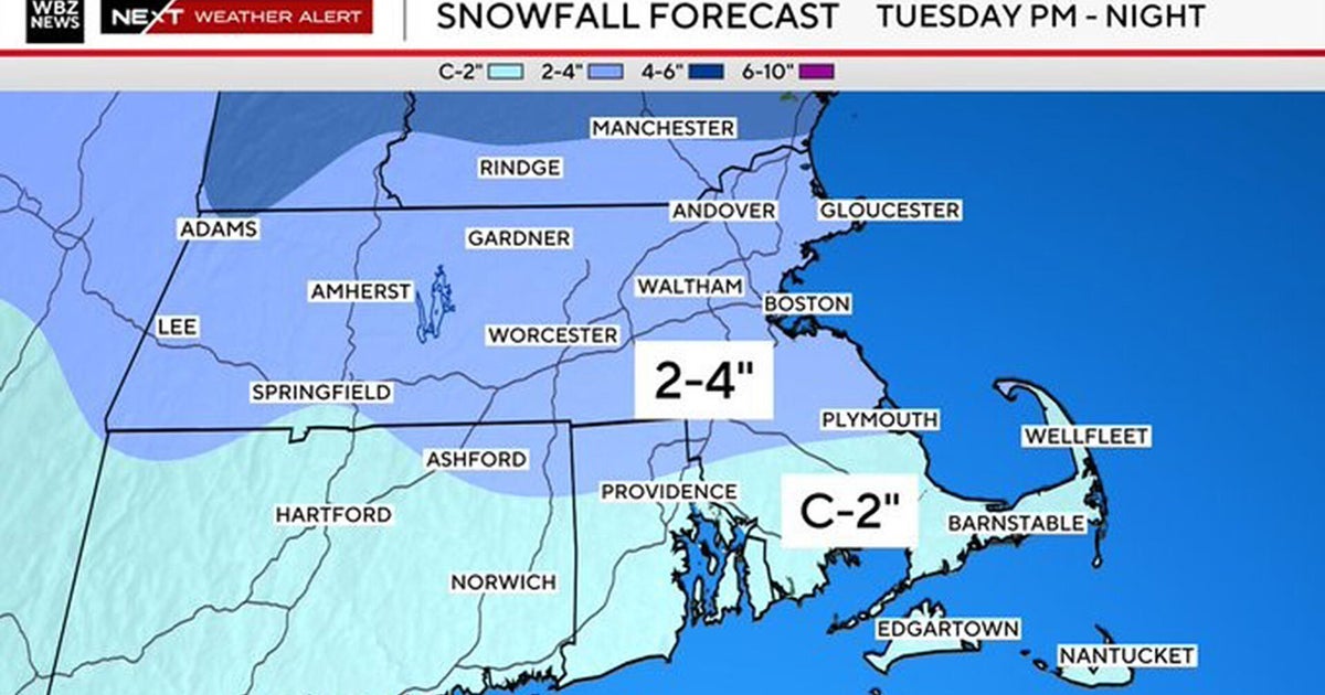
3...Rain to Snow around 8pm this evening with the last slug of moisture dropping 1-3" the Pike/Boston and northward into Middlesex Co.. Precipitation ends between 12 midnight and 2am.
This weekend: Saturday will be partly cloudy with increasing late-day clouds. Gusty winds early will calm thru the day. Highs near 30F. Light snow will develop Saturday night and continue thru Sunday afternoon. Models are spitting out .2 to .4" of precipitation which would add up to 2-4" of snow.
More heavy rain is possible on Monday. This active weather pattern continues...
Melissa :)