Threat of thunderstorms Thursday as heat wave likely becomes official in Massachusetts
BOSTON – The stretch of scorching weather in Massachusetts and New Hampshire is likely to officially become a heat wave on Thursday. The excessive heat is also bringing with it a threat of thunderstorms to end the week.
The WBZ Weather Team is continuing the NEXT Weather Alert for the next several days.
Heat wave likely to become official Thursday
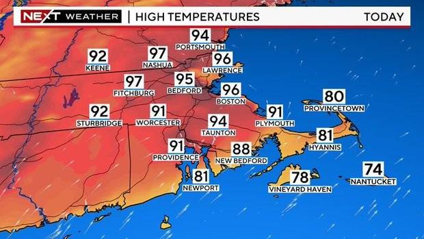
Much of the region will officially reach heat wave status on Thursday. A heat wave is classified when there are at least three days with temperatures over 90 degrees.
High temperatures on Thursday will be similar to Wednesday. If the cloud cover stays minimal, we would rise a few degrees higher, nearing 100 degrees in some areas.
This is dependent on the timing of a cold front that will be sliding southward from northern New England. If it moves a bit quicker, some cloud cover and a shower threat could hold temperatures back a bit in southern New Hampshire and northern Massachusetts.
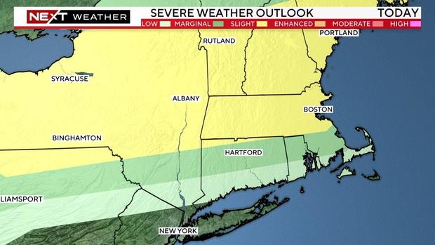
The main difference on Thursday will be to introduce the threat of thunderstorms in the afternoon and evening, particularly in southern New Hampshire and across Massachusetts. Scattered storms will be pushing eastward throughout the day, mainly after 2 p.m.
The Storm Prediction Center has placed parts of our area in a "slight" threat for severe weather.
Main concerns with any cells that form would be very heavy downpours, localized flooding, damaging wind, and the chance of some small hail.
Boston weather radar
Track the storms using our interactive radar map below:
Massachusetts Weather Radar
When will the Massachusetts heat wave end?
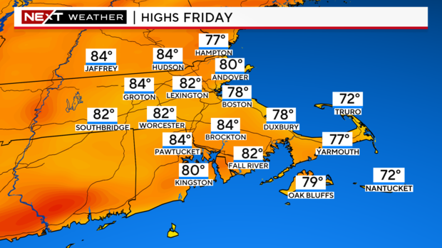
The cold front will be very slowly moving from north to south through Southern New England during the day on Friday. Therefore, the hottest temperatures will be in the morning hours. We could reach as high as 85-90 in the morning on Friday before the winds shift to the east-northeast with the passage of the front.
Once that front comes through, temperatures will fall back into the 70s and 80s.
Locations farther south and west of Boston will see the hottest temperatures given that the front will take longer to reach them. So, places like southern Worcester County and Connecticut should easily top 90 degrees for the fourth day in a row.
There will also be additional showers and thunderstorm popping up along the frontal boundary during the day Friday.

What will the weather be for the Celtics parade?
This forecast could work out to be ideal for the Celtics parade.
Ultimately this will come down to the timing and location of that cold front, but as of this writing we expect the front will be through Boston by 11 a.m. and temperatures will be cooling off.
We cannot rule out a shower or storm, although there is a much higher risk to the west of Boston assuming the front has already passed through.