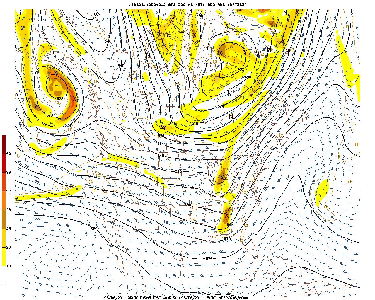
Upper level winds from the SW are advecting a warm balmy airmass up the east coast. But cooler air is charging back into the eastern half of the country so This warm balmy air is being lifted up, cooled, condensed into steady to heavy rains which are extending from Vermont to
the Carolinas today. These upper level winds ,which help to steer the weather, have been moving from south to North up the Ohio valley keeping the rain west of us for most of the weekend. The whole trough is gradually shifting east, and so the chance of rain are increasing this afternoon especially for northern, western and central regions. The coast will manage to squeeze out a pretty nice Sunday with breaks of sun and temps near 60 in spots.
500 mb Vort Map
The low and Vortmax currently in Georgia will race up the coast and track through Southern new England tonight. As we have been saying...tonight is where we are expecting the heaviest rain to occur with periodic heavy downpours and maybe some embedded thunder. This is an energized vort...which help to spark the severe weather in the Gulf last night. The low level jet will be racing through eastern MA and RI tonight. Heavy rains may briefly drag down some of these strong winds to the ground for brief gusts to 50 which may cause some scattered tree damage.
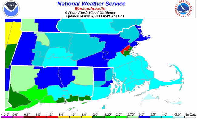
So the heaviest rain is expected to occur in western New England with the potential for 1.5-3", while lighter amounts are expected east...with solid 1-1.5" amounts with lesser amounts towards the Cape. Below is the 6 hour Flash Flood Guidance.
Anything above three inches will certainly cause problems...luckily most will not see that much. But there are a few areas who could reach the threshold necessary for flash flooding to occur. Towns like Medford, Melrose, Winchester, Belmont and Stoneham are vulnerable to urban flash flooding due to excessive runoff.They are in an area that only need about 1.2" in 6 hours to see some flash flooding. That is definitely possible. the heavy rain with the snow melt which has been going on all weekend could be just enough to flood some basements and create flooded roads early tomorrow morning. Another area vulnerable would be southwestern Connecticut.
So we could see some urban street flooding tomorrow morning during the morning commute. After that, the water and snow melt will continue to funnel into area rivers and streams which will be approaching flood stage and even going over Monday. Below are the river conditions from the Northeast River Center. There are several rivers which will be on the rise and cause low land flooding in the next few days
Rivers to Watch
Shawsheen at Wilmington
This river is expected to go above flood stage tomorrow and see moderate flooding by Tuesday. At this stage, 8 .2 feet...
FLOODING WILL AFFECT LOW LYING NEIGHBORHOODS FROM WILMINGTON THROUGH TEWKSBURY TO LAWRENCE. THIS INCLUDES A PORTION OF ROUTE 114 IN LAWRENCE. AREAS SUBJECT TO BASEMENT FLOODING SHOULD MOVE VALUABLES TO HIGHER GROUND.
Assabet at Maynard
The Assabet will likely go a foot above flood stage and stay just below the moderate flooding level
MINOR LOWLAND AND BACKYARD FLOODING IS LIKELY ALONG REACHES OF THE RIVER IN MAYNARD...CONCORD AS WELL AS HUDSON. SEVERAL RIVER ROADS MAY ALSO BECOME COVERED IN WATER.
Numerous other rivers and streams will see minor flooding...luckliy this storm will be quick moving and spare the region of any major flooding problems. The snow pack is still very much in place across central and Northern new England. The snow will absorb much of the rain..eventually refreeze again. But the amount of water in the snow depth is still a serious concern and will need to be watched carefully in the coming weeks ahead. Hard to image us getting out of this predicament unscathed.
Northern New England is a whole other ball game. Todays rain will be changing to snow in the far north with a mix of sleet and ice in the interior valleys. Where there is a change to snow...6-12+" Some ski areas will be reporting over a foot of new snow tomorrow. The freezing rain is more likely from Brattleboro and Springfield, VT to Lebanon and Meredith, NH to Farmington, Skowhegan Bangor Maine. Roads tomorrow morning across the north may be very hazardous for travel where we are having these ptype issues.
The storm will be quickly exiting Monday. A brief wintry mix change over is possible south before the precipitation shuts off. Temps will be falling through the day Monday. Temps will be below freezing by sunset.
High barometer cool air from Canada will make for a seasonal chilly midweek with sunshine...before our next system arrives to end the week. The pattern has slowed down some and a more complex look is in place. This will need a closer look which I will do tonight...for now...I need a nap!
