Another parade of storms? Previewing the February weather forecast for Massachusetts
Will this February bring warmer temperatures, or can Massachusetts expect cold and snow? Read the latest from the WBZ NEXT Weather Team.
BOSTON - Hello, fellow cave dwellers!
I come to you with good news ... January is finally over and not a moment too soon!
January 2024 will go into the books as one of the cloudiest and wettest Januarys on record.
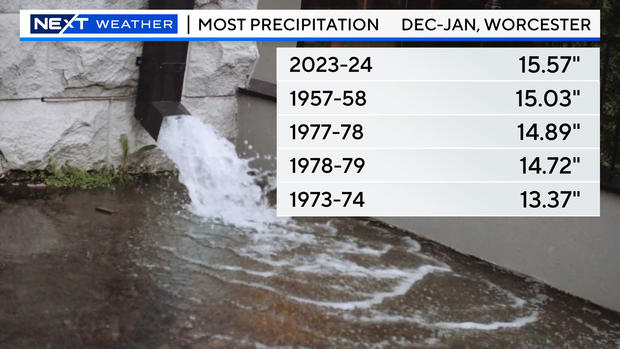
With 7.64" of precipitation, it was the fourth-wettest January ever recorded in Boston and the third-wettest in Worcester (over 8").
If you combine the last two months, December and January, it was the fifth-wettest in Boston and, in Worcester, THE WETTEST December-January combo ever recorded with over 15" of water!
February is here to save the day! Well, sorta ...
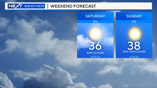
The clouds will be sticking around through most of the day Friday. This weekend will be colder BUT, with a return of some sunshine!
One caveat: Some clouds may linger over portions of southeastern Massachusetts on Saturday, so folks down there may need a little more patience.
What's the long-term weather forecast for February in Massachusetts?
Looking farther ahead to February as a whole:
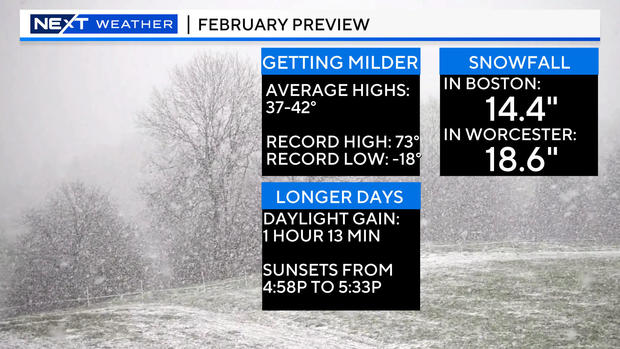
This is the month when we start to turn things around. Average high temperatures rise from the upper 30s into the lower 40s.
We gain more than an hour of daylight and push sunsets past 5:30 p.m.
It also tends to be, on average, our snowiest month of the year, averaging more than 14" in Boston.
February 2024 will start off quietly.
In fact, assuming a storm system misses to our south around the middle of next week, this could be our longest stretch of dry weather in quite some time.
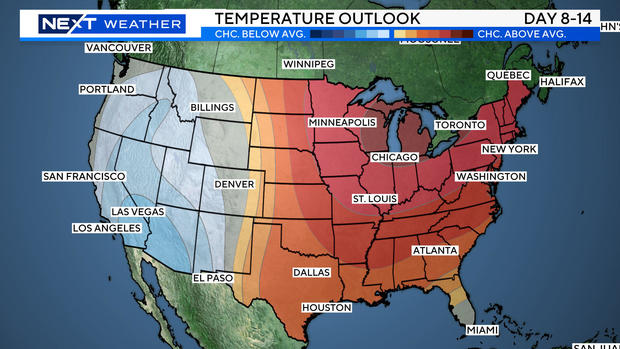
Temperatures will largely be near to above average across the eastern half of the country for the first 1-2 weeks of February.
Things could get quite mild in New England later next week if the current model forecasts hold.
Can Boston expect more winter weather?
BUT ... you knew that was coming didn't you ... regardless of what Punxsutawney Phil says Friday, I do NOT think winter is done with us yet.
Odds favor one last push of cold and snow during the second half of February and perhaps, into March as well.
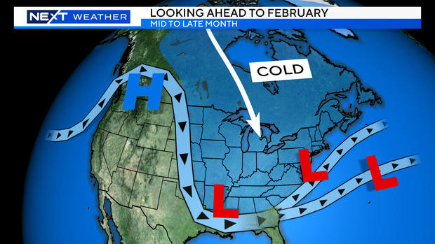
A familiar, El-Nino-like pattern is likely to set up with an active, parade of storms across the south-southeastern United States later this month.
At the same time, there may be a ridge of high pressure setting up in parts of Alaska and the northwestern U.S. that will serve to funnel cold, Arctic air down into the central and eastern U.S.
This type of pattern would mean several powerful storms coming out of the Gulf of Mexico and southern states. While some could miss to our south, others may ride up the East Coast with loads of rain, snow and wind.
In the end, this winter could largely be remembered by what happens in the next 4-6 weeks. A couple of big "hits" versus near misses could change perception in a big way. One thing is for sure as we sit here on Feb. 1, winter almost certainly has a few "punches" left.
