Fall Spectacular This Weekend....Much Ado About Hybrid Storm
It is hard to find anything wrong with this weekend forecast. Crystal clear skies thanks to High pressure right over us. A few fair weather clouds may try to pop in the afternoon inland, otherwise sun-filled skies, light winds with highs in the Lwr-mid 70's inland today, with slightly cooler temps in 60's to near 70 with a light onshore wind for the beaches. Picture perfect. Another night with cool temps in the 40's for most suburbs under light winds with the high cresting over us. High pressure will be just off the coast Sunday with more sunshine, a light ESE flow with slightly cooler air. Lwr 70's inland and mid 60's at the coast. Just so invigorating outside. It makes you grateful to be alive! I am heading to the apple orchard to go apple picking with the family today. Honestly, I am terrified of the scene which awaits me. I have heard the stories. Hoping for the best!
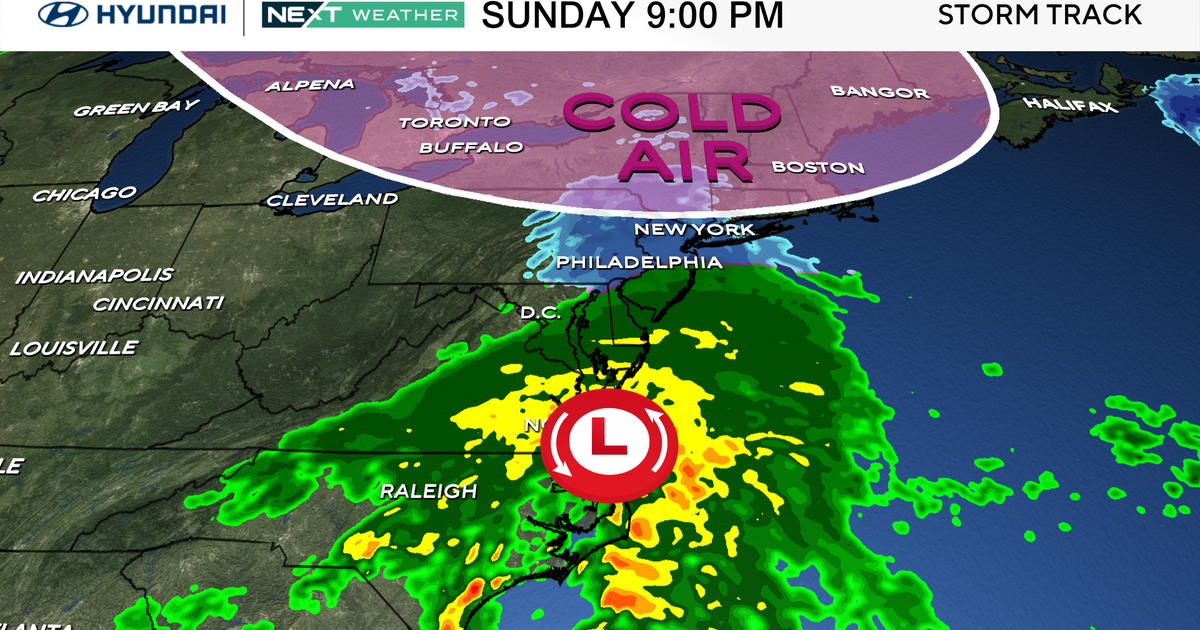
Of course, we continue to keep an eye on a developing storm in the western Atlantic Ocean, a few hundred miles off the Carolina coastline. This will be strengthening Sunday and heading north. In the process, it may even gain some sort of eye like structure. If it gets strong enough, it could even become Karen...but in the process likely become sub-tropical over the cooler waters near New England. Either way, this storm will mean little to New England. Most of the energy will remain far enough off the coast as the low tracks about 200 miles east of Nantucket Monday morning. Breezy NE winds will affect the eastern coast of MA...mainly the Cape & Islands. A few showers may spin off of the low and rotate into coastal MA Monday. Under the cloudy damp conditions, Temps will be cool and raw 60-65 at the beach. Inland will be much different with light winds, cloudy to partly sunny skies with highs in the 60's to near 70...especially in western New England who should have a pretty decent day. The worst I can find with this storm is seas building upto 5-7 feet off the coast which could make for some pounding surf for a time Monday for more expose SE facing beaches. How quickly this storm pulls away is still in question, but by Tuesday, this storm is moving up into Nova Scotia with drying NW winds following in on the backside with clearing skies.
Upper level ridging follows in behind the storm with warmer temps. Wednesday should see highs climbing to near 80 degrees. A weak front pushes through for slightly cooler air in the Lwr-mid 70's for Thursday-Friday with more sunshine and high pressure. Next weekend will see a warming SW wind
ahead of a cold front which promises to bring in a cooler feel once past October 6th.


