Expect Snow Between Wednesday Afternoon And Thursday Night
BOSTON (CBS) - Don't count out winter just yet.
We have gone nearly the entire month of February without any measurable snow in Boston, so close to tying the record for the least snowy February set back in 1925 and again in 1937.
But, due to the leap year, February has one extra day this year and snow is in the forecast on February 29th.
Check: Current Conditions | Weather Map Center | Interactive Radar
It isn't going to be a typical New England snowstorm, but then again we really haven't had one of those yet this season.
Early on Wednesday morning a large storm system will be bringing rain and snow to the upper Midwest. The center will be located near Minneapolis, well over 1,000 miles from Boston.
Watch Melissa Mack's forecast:
A weather boundary will extend out several hundred miles from the storm's center, stretching east through parts of Indiana, Ohio, Pennsylvania and offshore along the Mid-Atlantic states.
Most of the precipitation along this front will be rain, but as the boundary edges northward through New Jersey it will begin to run into a cold high pressure area centered over northern New England.
By late Wednesday afternoon, the first wave of precipitation will be arriving in New England as a wintry mix and our late February, early March storm will be underway.
The thing about this storm is that it truly isn't just one storm, it will be several waves, or small storms riding along that weather boundary to our south.
Timing these waves of precipitation and determining which may become stronger or more significant will be the key.
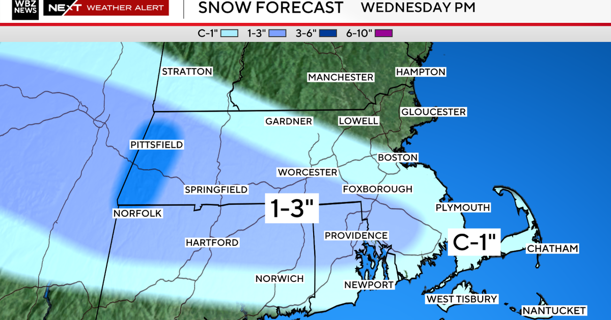
Right now it looks like wave number one will slide to our south late Wednesday afternoon and evening and bring light snow to areas north and west of Boston, a mix along the coast and in the city, and mainly rain south of the Pike.
There could be a small snow accumulation (a few inches), especially in higher elevations north and west of Boston.
A second wave will likely develop in the early hours of Thursday and this could bring our most significant precipitation from the entire event.
The key to this storm will be its position and track - how far south it develops and how far north its shield of steady snow reaches.
The latest model runs have it close enough to bring some snow accumulation to the Boston area and nearby suburbs, another couple to several inches during Thursday morning, likely having an impact on the commute.
One final wave appears as though it may affect New England Thursday evening and night.
This would almost certainly be snow and could bring an additional few inches to nearly the entire region.
So as you can surely tell from the description of events above, there is a high degree of difficulty in forecasting snow amounts with this system, but there are a few conclusions that we can make, even this early.
All of New England will likely see some snow between Wednesday afternoon and Thursday night.
The most likely places to see any significant snow accumulation are the northern and western suburbs of Boston, mainly due to some mixing/rain at times in the City and to the South.
Wintry precipitation is the main concern and biggest factor from this system, winds and coastal issues will be non-existent or minor.
Final snow accumulations are not likely to be blockbuster, but could be light-to-moderate - something in the range of 1-to-3 inches or 3-to-6 inches.
But again, due to the complex nature of the storm it is too early to be more specific.
You can follow Terry on Twitter at @TerryWBZ.